
Directions
Shelters 1, 2 and 3 are located at the Sutton Dam. From I-79, take Exit 62 toward Sutton/Gassaway. Turn left on SR-4, approximately 2 miles into Sutton. Turn right at the stop sign, cross the Elk River, and turn left to the dam. Shelters 4 and 5 are located in the Bee Run Day-Use Area. From I-79, take Exit 67 toward Flatwoods. Turn right on SR-4. Go 1 mile to SR-15 and turn left. Continue a mile to Bee Run Day-Use Area and turn right. NOTE: GPS directions are not always accurate.
Phone
304-765-2816
Activities
BOATING, CAMPING, FISHING, HIKING, SWIMMING SITE, OTHER RECREATION CONCESSION SITE
Keywords
SLPS,SHELTER #5 – BEE RUN AREA,SHELTER #3 – SOUTH ABUTMENT AR,SHELTER #2 – DOWNSTREAM AREA,SHELTER #1 – DOWNSTREAM AREA,SHELTER #4 – BEE RUN AREA,Sutton Dam,South Abutment,Bee Run,Downstream,Elk River.,SUTTON LAKE
Related Link(s)
West Virginia State Road Conditions
Overview
Sutton Lake Picnic Shelters overlook Sutton Lake and the Elk River in central West Virginia, 70 miles north of Charleston and 60 miles south of Clarksburg. The area provides a wide variety of recreational activities, including boating, swimming, fishing and hiking.
Recreation
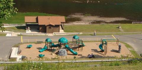
Sutton Lake’s five recreation areas offer many recreation opportunities for visitors. Three campground have sites available for reservation or on a first come, first serve basis. Boat may be launched in all of the lakeside recreation areas. Below Sutton Dam, there is a small boat ramp accessing the Elk River. All three Day Use Areas have fishing platforms. Kids love the playgrounds. Anglers find plentiful bass, crappie, catfish and sunfish in the lake. Below the dam, the Elk River is well-known for its muskie and walleye fishing, and trout are stocked in the Tailwaters. Fire roads and hunting trails in the surrounding lands provide great hiking and biking opportunities around Sutton Lake and at the nearby Elk River Wildlife Management Area.
Facilities
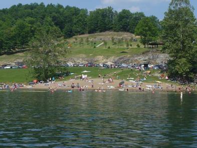
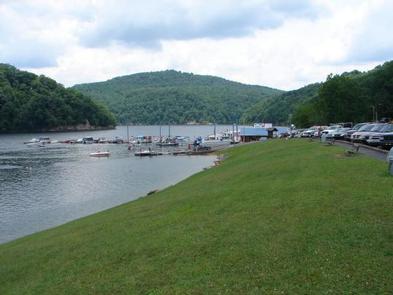
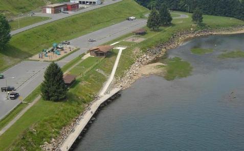
Sutton Lake Day Use Areas offers five picnic shelters, each with six to eight picnic tables and a large charcoal grill. Shelters 1 and 2 are in the Downstream Area, overlooking the Elk River. Both shelters have water and electric hook-ups and Shelter 1 is accessible. There is a playground, fishing pier, small boat access, horseshoe pits and corn hole in the area. Other facilities include a large parking area and accessible flush toilets. Shelter 3 overlooks Sutton Lake in the South Abutment Day Use Area, just upstream from the dam. Visitors in this area enjoy the lakeside fishing pier, small beach and boat ramp. There are vault toilet facilities in the area. Shelters 4 and 5 overlook Sutton Lake from the Bee Run Day Use Area. Water and electric hookups are available at each shelter. Amenities include a playground, a large beach, and the Sutton Lake Marina. Area facilities include flush toilets and ample parking. Shelter 5 is ADA accessible, although there is not direct ADA access to the restroom facilities.
Natural Features
Sutton Dam is an impressive 210′ tall and 1178′ wide concrete dam, backing up Sutton Lake, which covers 1440 acres as it winds 14 miles up the Elk River. Many quiet coves can be found along its 40 miles of shoreline. The lake is surrounded by rolling hills wooded with mixed stands of oak, hickory, poplar and cherry trees. Wildlife, including deer, bears, turkeys, squirrels, ruffed grouse, Canada geese and other waterfowl are abundant in the area.
Nearby Attractions
Sutton Lake Marina is nearby in the Bee Run Area. It is a private concession with a snack bar, boat and slip rentals and more. Camping is available at Gerald Freeman, Bakers Run and Bee Run Campgrounds.
The Elk River Wildlife Management Area contains nearly 18,000 acres of public hunting lands. The terrain is diverse and divided into the Elk River and Holly River sections. The Elk River section consists primarily of steep hills, ridges and benches, where the Holly River section is on the north side of the lake and consists of forested hills and open farmlands.