DRY WOLF CABIN, MT Campground Reservation, Info, Images, Map, Directions

DRY WOLF CABIN, Montana Campground Images, Info & Reservations

Listen

Directions

From Stanford, Montana, go a mile northwest on US 87, then turn left on County Road 251 (Dry Wolf Road). Continue for 15 miles and look for a sign to Dry Wolf Station. Turn left onto short parking spur of the cabin site.

Phone

406-236-5511 OR 406-566-2292

Activities

BIKING, CAMPING, FISHING, HIKING, HUNTING, WILDLIFE VIEWING, MOUNTAIN BIKING, CROSS COUNTRY SKIING, SCENIC DRIVE, SNOWMOBILING

Keywords

DRYW,DRY,WOLF,LEWIS AND CLARK NF – FS

Related Link(s)

Rec Area Info & Images

Montana State Tourism

Montana State Road Conditions

Overview

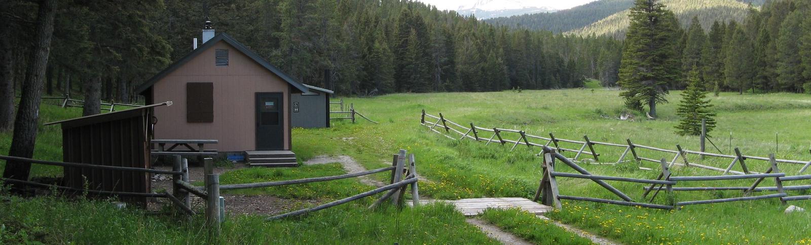
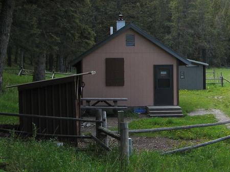
Dry Wolf Cabin is located about 20 miles southwest of Stanford, Montana, in the Little Belt Mountains. The rustic cabin is conveniently located along Dry Wolf Creek, providing a pleasant setting for anglers, wildlife watchers and hikers.

When snow arrives, access on the graveled county road is by four-wheel-drive only.

Recreation

Anglers seek brook and rainbow trout in Dry Wolf Creek. A variety of horseback riding and hiking trails originate within a few miles of the cabin. Trails for mountain bikers and off-road vehicle riders are also in the area. Cross country skiing is popular in winter months.

Facilities

The cabin is a one-room structure that sleeps five. Amenities include a propane cook stove, propane lights and a wood stove for heat. Firewood is provided and is located in the storage shed near the cabin. Dishes and pots and pans are available, and a vault toilet is located outside.

No water or electricity is included. Guests are expected to bring bedding, food, water, garbage bags, a cooler, flashlights, toilet paper and personal necessities. (Click here for more cabin details.)

Pets are not allowed in the cabin, but can be kept outside in a kennel or on a six-foot or less leash.

Natural Features

The cabin is nestled along Dry Wolf Creek at an elevation of 5,600 feet. Dry Wolf Creek is a tributary of the Judith River and flows north for about 40 miles in the Little Belt Mountains. Surrounding peaks include Gibson Peak and Butcherknife Mountain.

Nearby Attractions

Groceries and fuel may be found in Stanford, approximately 20 miles from the cabin. Bandbox Mountain, about an hour’s drive, is a good place to hunt for marine fossils that are more than 100 million years old.

Reservation

More from CampingHiking.net:

LITTLE BROOKLYN LAKE GUARD, Wyoming Campground Images, Info & Reservations

Listen Directions From Laramie, Wyoming, take Hwy 130 to Centennial, Wyoming. Travel approximately 9 miles west of Centennial on Highway 130 to Brooklyn Lake Road (Forest Service Road 317) located on the north (right) side of the highway. The Guard Station is on Brooklyn Lake Road approximately 1 mile from

PROSSER RANCH GROUP, California Campground Images, Info & Reservations

Listen Directions From either east bound or west bound Interstate 80 in Truckee take exit 188, Highway 89 north toward Sierraville. In aproximately 3.5 miles turn right at the sign for Prosser Recreation Sites then in about two miles the campground will be on the right. Phone 530-587-3558. FOR RESERVATIONS,

SILVERTIP CABIN, Montana Campground Images, Info & Reservations

Listen Directions From Hungry Horse, drive east on Highway 2 to Martin City, then south on Forest Road 38. Drive about 55 miles on a winding, gravel road, along Hungry Horse Reservoir. At the junction with Diamond R Guest Ranch, turn east on Forest Road 568 and travel approximately 15

ALTAMONT, Utah Campground Images, Info & Reservations

Listen Directions From Salt Lake City, Utah, travel south on I-15 to Alpine-Highland exit 284. Travel east on Highway 92 approximately 13 miles through American Fork Canyon, then 3 miles south on the Alpine Loop Scenic Byway. Campground is on the left. Phone PLEASANT GROVE RANGER DISTRICT 801-785-3563 OR UTAH

BIG SILVER GROUP, California Campground Images, Info & Reservations

Listen Directions From Highway 50, turn north onto the Ice House Riverton Road and continue 18 miles. After crossing Big Silver bridge turn left into campground entrance. Phone 831-245-6891 Activities BIKING, BOATING, CAMPING, FISHING, HIKING Keywords BSIL,Crystal Basin,Icehouse Road,ELDORADO NF – FS Related Link(s) Rec Area Info & Images California

BUCK LAKE GROUP CAMPGROUND, Florida Campground Images, Info & Reservations

Listen Directions From I-75 in Ocala, Florida, travel east on State Route 40. Turn onto State Route 19 south, then turn right onto Forest Road 595-2 and travel for approximately 4 miles. Buck Lake Group Camp will be on the left. Phone 352-625-2520 Activities BOATING, CAMPING, FISHING, HIKING Keywords BLGR,Buck