LUNCH PEAK LOOKOUT, ID Campground Reservation, Info, Images, Map, Directions

LUNCH PEAK LOOKOUT, Idaho Campground Images, Info & Reservations

Listen

Directions

From Sandpoint take Hwy 200 east 12 miles to Trestle Creek Road; turn left onto Trestle Creek Road #275 and go 12 miles to Lunch Peak Road #1091; turn left onto Road 1091 and go 4 miles to the lookout.

Phone

208-263-5111. WEEKDAYS 8:00AM TO 4:30PM. CLOSED ON WEEKENDS. CANNOT ACCEPT OR CANCEL RESERVATIONS

Activities

BIKING, CAMPING, HIKING, HORSEBACK RIDING, HUNTING, WILDLIFE VIEWING

Keywords

LUNC,lunch peek

Related Link(s)

Rec Area Info & Images

Idaho State Road Conditions

Idaho State Tourism

Overview

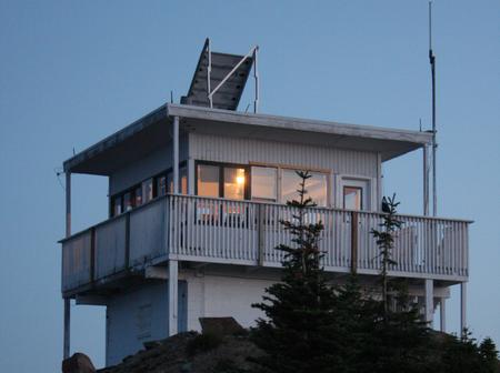
Lunch Peak lookout offers breathtaking views of Cabinet Mountain Wilderness, the Selkirk Mountains and Lake Pend Oreille. Located in the Cabinet Mountains, 35 miles northeast of Sandpoint, Idaho, the lookout sits at 6,414 ft. Guests can enjoy easy access to Pend Oreille Divide Trail #67. The lookout is remote and rustic with no heat, furnishings, water or cooking facilities. This basic structure lets visitors experience the feeling of “roughing it” while enjoying the cozy shelter and incredible views of the mountains and valleys below.

Recreation

The Pend Oreille Divide Trail #67 starts just below the lookout and is suitable for hiking, horseback riding and mountain biking. It follows ridge lines for much of its length and offers great views in all directions. A nice day hike is out to Mt. Pend Oreille and back. 8 miles roundtrip.

Facilities

The 15’x15′ cabin was remodeled in 2002 and sits atop a 15′ high cinder block foundation. No water or heat is provided. The lookout has limited furnishings which include a sleeping platform, table and cabinet. A modern vault toilet is located at the Pend Oreille Divide trailhead, 300 feet away. The last four miles of the access road is rough in spots and high clearance vehicles are necessary.

Natural Features

The lookout is located northeast of Sandpoint, Idaho and Lake Pend Oreille at an elevation of 6,414 feet. Bear, deer, elk, and cougar are among the wildlife native to the area. Visitors are cautioned to be aware of and practice bear safety while staying at Lunch Peak Lookout.

Nearby Attractions

The closest convenience store and fuel is located in Hope, Idaho, approximately 20 miles or a one hour drive.

Charges & Cancellations

CLOSED 2020

Reservation

More from CampingHiking.net:

MUSTANG, Texas Campground Images, Info & Reservations

Listen Directions From FM 1187 Crowley Plover Road, turn north on Winscott Plover Road for a mile (0.6 km) to the park entrance. Phone 817-292-2400 Activities BOATING, CAMPING, FISHING, PICNICKING, SWIMMING SITE Keywords MUS2,BENBROOK LAKE Related Link(s) Rec Area Info & Images Texas State Tourism Texas State Road Conditions Overview

WINNIE DAM CAMPGROUND, Minnesota Campground Images, Info & Reservations

Listen Directions From Deer River, Minnesota, take Highway 2 west for one mile. Turn right on Highway 46 and go 12 miles. Turn left on Itasca County 9 and continue 2 miles, then turn left at signs and follow to the campground. Phone 218-326-6128 Activities CAMPING Keywords LAKW,WINNI DAM CAMPGROUND,WINNI

FISHERMENS BEND, Oregon Campground Images, Info & Reservations

Listen Directions Fishermen’s Bend is located 29 miles east of Salem on Hwy 22, and 1.5 miles west of Mill City. Phone 503-897-2406 Activities BIKING, BOATING, CAMPING, INTERPRETIVE PROGRAMS, FISHING, HIKING, PICNICKING, VISITOR CENTER, WILDLIFE VIEWING Keywords FIBE,FISHERMEN S BEND REC SITE,FISHERMAN’S BEND Related Link(s) Rec Area Info & Images

DIAMOND, Utah Campground Images, Info & Reservations

Listen Directions From I-15, take exit 258 and turn east toward Spanish Fork Canyon. Continue up Spanish Fork Canyon for about 9 miles to Forest Road 029/Diamond Fork Canyon. Turn left into Diamond Fork Canyon and travel 6 miles northeast to campground. Phone SPANISH FORK RANGER DISTRICT 801-798-3571 OR UTAH

THREEMILE CAMPGROUND, Wyoming Campground Images, Info & Reservations

Listen Directions From Cody, Wyo., follow Sheridan Avenue west through Cody until the road leaves town and becomes the Buffalo Bill Cody Scenic Byway (U.S. Highway 14/16/20). The campground is located almost 49 miles west of Cody, on the south side of U.S. Highway 14/16/20, next to the Shoshone River.

NORTH SANDUSKY CAMPGROUND, Illinois Campground Images, Info & Reservations

Listen Directions From I-57 take exit 77 and turn west on Route 154. After 4.5 miles turn south onto Rend City Road. Continue through the four-way stop and follow signs to the campground. Phone 618-724-2493 Activities BOATING, CAMPING, FISHING, SWIMMING SITE Keywords NSAN,REND LAKE,NORTH SANDUSKY,THE SANDUSKYS,PINTAIL,RINGNECK,WOODUCK,SHAGBARK,MAPLE,SWEETGUM,HICKORY,WHITE OAK,DUCK LOOPS,BY COY &