

Directions
From I-90, take Exit #43 (Kingston) and drive 24 miles north on Forest Highway 9 to Prichard junction. From there, continue on Forest Road 208 for about 5 miles to Forest Road 602 (on the right just past Shoshone Base Camp). Drive about 9 miles to the lookout at the end of the road. Vehicles with high clearance and good tires are strongly recommended.
Phone
208-783-2363
Activities
HISTORIC & CULTURAL SITE, CAMPING, HIKING, HUNTING, WILDLIFE VIEWING
Keywords
LILO,LITTLE GUARD,IDAHO PANHANDLE NF – FS
Related Link(s)
Overview
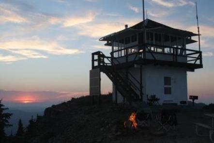
Little Guard Lookout, located about 9 miles north of Shoshone Camp, was one of the last remaining fire lookouts used in the Coeur d’Alene River area and has only just recently become inactive.
The structure standing today on Little Guard Peak is the third in a series of lookout buildings that originated back to 1919. In October 1990, Little Guard Lookout was accepted for listing in the National Historic Lookout Register and the first for Idaho.
Recreation
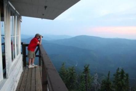
Hiking is a great way to explore and take in the scenery of the grand mountains. The lookout provides access to the Shoshone Ridge Trail #81, a very nice day hike for visitors to the lookout. The trail provides many scenic viewpoints, but there is no source of water along the way, so hikers must bring plenty of their own.
Facilities
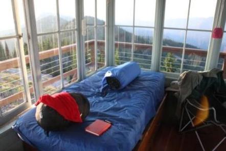
The fully furnished two-story fire lookout has dimensions of 14 x 14 feet, an external cat walk, and a gabled roof. It sleeps four guests, with one single bed and three fold-up cots available. Quarters are tight and at least two cots will need to be set up downstairs in the kitchen area.
The kitchen is on the ground floor and is equipped with a small propane refrigerator, propane cook stove, table, chairs and basic cooking utensils. Propane for the stove and refrigerator is also provided.
The outdoor pit toilet is within 200 feet of the lookout. It comes with biodegradable toilet paper. Other amenities include a propane heater upstairs and propane lanterns, but renters will need to bring their own propane for these.
No water or electricity is available. Visitors should bring plenty of water. A mountain spring is within a half-mile by footpath, and can be boiled and treated for consumption.
In addition to water, guests should bring food, propane for lanterns and heater, matches or lighters, warm clothing, garbage bags, insect repellent, towels and washcloths, toiletries, dish soap and a first aid kit. Air mattresses or sleeping pads are also recommended.
Natural Features
At an elevation of 6,031 feet, the lookout boasts spectacular views overlooking the North Fork of the Coeur d’Alene River and the Bitterroot Mountains, with views of nearby Downey Peak to the northwest.
Wildlife in the area includes mule deer, moose, osprey and calliope hummingbirds.