

Directions
From Saguache, go north on Hwy 285 for 15 miles to Villa Grove. Take the Bonanza turnoff, County Rd LL56, on the left 0.1 mile north of Villa Grove. Stay on LL56 about 13 miles west to the "Brewery Creek " sign and make a left turn, crossing a bridge. Travel on Forest Road #880 for 1.5 miles. The gate is located .25 miles before the cabin.
Winter access may be limited to showshoes, skis or snowmobile. During the spring snow melt, March through mid May, hiking 1.5 miles may be the only option for accessing the cabin. Seasonal road closures may also be in effect, check conditions prior to your arrival.
Phone
719-655-2547
Activities
BIKING, HISTORIC & CULTURAL SITE, CAMPING, FISHING, HIKING, HUNTING, WINTER SPORTS, WILDLIFE VIEWING
Keywords
BCGS,Brewery Cabin,Brewery Ranger Station,RIO GRANDE NF- FS
Related Link(s)
Colorado State Road Conditions
Overview
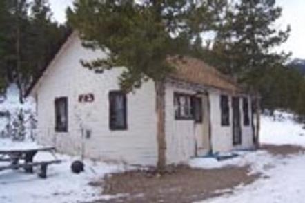
Brewery Creek Guard Station is situated at an elevation of 9,500 feet in a densely wooded aspen grove overlooking Brewery Creek. The cabin is a few miles south of the Continental Divide on the northern end of the San Luis Valley in the Rio Grande National Forest.
Built in 1935, the two room cabin was originally used by a forest ranger who oversaw the Poncha and Bonanza Districts of what was then called the Cochetopa National Forest.
Today the cabin is a comfortable getaway for guests seeking relaxation and recreation in south central Colorado.
Recreation
The area offers many opportunities for hiking and off-road vehicle adventures in summer, hunting in the fall, and cross country skiing and snowmobiling in the winter.
Several hiking trails are in close proximity to the cabin, including several leading up to Antora and Antora Meadows.
Facilities
The cabin is furnished with three bunkbeds (the top is a single bed, the bottom is a fold-out futon couch that sleeps two) and can accommodate up to nine people.
The cabin has stove, refrigerator and heater, all powered with propane. The kitchen is equipped with cooking utensils and some pots and pans. Picnic tables, a fire pit and a outdoor vault toilet are also on site.
The guard station does not have electricity, though water is available from an outside hand pump. Water is also available at the Saguache Ranger District Office during business hours from May through November.
Although the cabin has most amenities, guests do need to provide their own food, sleeping bags, linens, towels, dish soap, matches, cooking gear, first aid kit, toilet paper and garbage bags. It is recommended that guests bring an additional light source in case of emergencies.
Natural Features
The cabin offers wonderful views of Antora Peak (13,266 feet) and Windy Point (12,129 feet) towering over the valley. Active beaver dams occupy the nearby creek just below the cabin, where anglers can cast a line into the frigid waters. Elk, deer, and other wildlife are often seen in meadows adjacent to the cabin.
Nearby Attractions
Brewery Creek Guard Station is located 2 miles from Bonanza, a historical silver mining town that was booming in the 1880’s. Today visitors to Bonanza can see old mines, historical buildings, and old time mining equipment as they follow the Bonanza Mines Off-Highway Vehicle Tour. Maps for the Bonanza Off-Highway Vehicle Tour are available at the Saguache Ranger Station.