Henneberry House, MT Campground Reservation, Info, Images, Map, Directions

Henneberry House, Montana Campground Images, Info & Reservations

Directions

Access to the cabin is a short distance off I-15 south of Dillon. From Dillon, take the Dalys exit (#51) and turn left under the interstate, then right on the frontage road approximately 1/4 mile to an access gate and parking area on your left. You will need a combination to open the locked gate, and should lock the gate behind you to prevent other unauthorized vehicle use on this road. From here, the cabin is only 1/4 mile ahead on a lightly maintained gravel road.

Phone

406-683-8000

Activities

CAMPING, FISHING

Keywords

None

Related Link(s)

Rec Area Info & Images

Montana State Tourism

Montana State Road Conditions

Overview

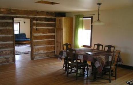
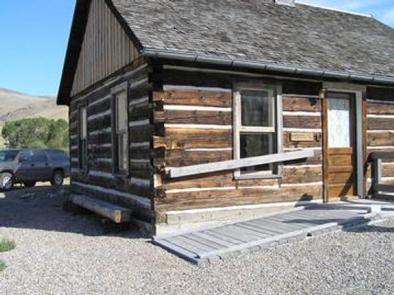
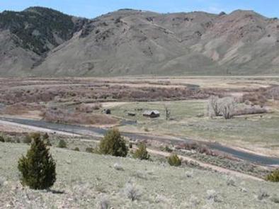
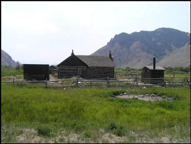
This historic cabin, built in 1905, is located approximately 14 miles south of Dillon, Montana, on the banks of the Beaverhead River. The cabin provides access to a variety of outdoor recreational activities on adjacent public lands. The cabin and surrounding lands are managed by the Bureau of Land Management.

Recreation

Recreation opportunities are right outside the door with world-class trout fishing on the Beaverhead River. There may also be opportunities for waterfowl hunting. Nearby opportunities for hunting, hiking, fishing, and 4WD touring through the mountains are plentiful.

Facilities

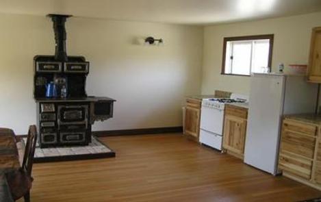
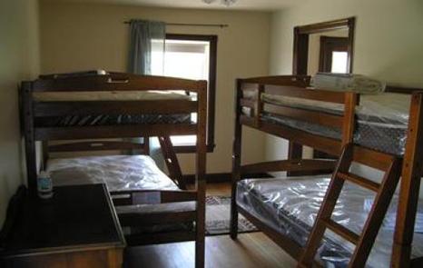
The cabin sleeps a maximum of eight people on two queen size fold-out futons, and four bunk beds; bedding is not provided. A propane stove/oven, lights, and small refrigerator, wood cook stove, wood stove, outhouse, non-potable water pump, and basic cooking and eating utensils are provided. No potable water is available. Firewood and propane are provided.

Natural Features

The Beaverhead River flows alongside the cabin across from Gallagher Creek and beneath Gallagher Mountain.

Nearby Attractions

The Beaverhead River, Clark Canyon Reservoir, Lewis and Clark National Historic Trail, Bannack State Park, and Virginia City are all opportunities for additional exploration in the surrounding area.

Reservation

More from CampingHiking.net:

UPPER PINES, California Campground Images, Info & Reservations

Directions Take Highway 41 north from Fresno, Highway 140 east from Merced, or Highway 120 east from Manteca into Yosemite National Park. Follow signs to Yosemite Valley and the campgrounds. Phone (209)372-8502 Activities CAMPING Keywords Yosemite National Park,The Valley Related Link(s) Rec Area Info & Images National Park Services Concessionaire

STARKEY CAMPGROUND, Arkansas Campground Images, Info & Reservations

Directions From Rogers, Arkansas, take Highway 62 east for approximately 28 miles. Turn right onto Highway 187 towards Beaver Dam and travel 5.5 miles. Turn right onto Mundell Road and follow it 3.9 miles to the campground. Phone 479-253-5866 Activities BOATING, CAMPING, HIKING, HUNTING Keywords None Related Link(s) Rec Area

PAINT CREEK DAM SITE, Ohio Campground Images, Info & Reservations

Directions From Chillicothe Ohio, take Route 50 west for 18 miles to Bainbridge. Ohio. Three miles past Bainbridge, turn right on Rapid Forge Road. Go 2 miles north and turn left into the Paint Creek Dam Site Area. Little Pond Shelter is located on the right just before crossing the

HANNA FLAT, California Campground Images, Info & Reservations

Directions Travel east on I10 (Highway 330) to Running Springs. Turn onto Highway 18 and continue to Big Bear Lake Dam but do not cross the dam. Highway 18 becomes Highway 38. Continue to the Fawnskin Fire Station and turn left onto Rim of the World Drive (Forest Route 3N14)

POOLE KNOBS, Tennessee Campground Images, Info & Reservations

Directions From downtown Nashville, TN, take I-40 east to I-24 east. After 15 miles take exit 66B and turn right onto Sam Ridley Parkway. Turn right onto Highway 41 north, and after about 1.5 miles turn right onto Fergus Road. Make another right onto Jones Mill Road and follow the