BIG LAKE, OR Campground Reservation, Info, Images, Map, Directions

BIG LAKE, Oregon Campground Images, Info & Reservations

Listen

Directions

From Eugene, Oregon, take I-105 east to McKenzie Highway 126. Travel east on 126 for 90 miles to Santiam Pass. At the top of the Pass, turn right onto the access road (sign says Hoodoo Ski Area, Big Lake Road, & Benson Sno-Park). Travel one mile to the fork in the road and stay left on Forest Service Road 2690. Continue for 2 miles to the entrance to Big Lake Campground on the left.

Phone

801-226-3564

Activities

BIKING, BOATING, HIKING, OFF HIGHWAY VEHICLE, SWIMMING, NON-MOTORIZED BOATING, WATER SKIING

Keywords

BIOR,WILLAMETTE NF -FS

Related Link(s)

Rec Area Info & Images

Oregon State Road Conditions

Forest Service Concessionaire

Oregon State Tourism

Overview

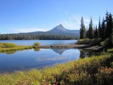
Big Lake Campground sits at its namesake lake along Santiam Pass, a 4,800-foot mountain pass through the Cascade Range in western Oregon.

Campers enjoy views of the lake with the beautiful Mt. Washington as a backdrop.

Recreation

Water skiing, sailing and swimming are among the favorite activities at the lake. The Patjens Lakes Trail offers excellent hiking opportunities. The trail follows the western side of Big Lake, heads south into the Mt. Washington Wilderness, passes alongside the scenic Patjens Lakes, and then loops back to the campground.

Facilities

Big Lake Campground offers 49 spacious campsites for tent or RV camping. Drinking water, vault toilets and a boat ramp are provided.

Natural Features

Surrounded by Alpine fir, hemlock and lodge pole pine, the campground sits on the western side of the lake.

Big Lake, at elevation 4,600 feet, is in the Willamette National Forest, which spans 1.6 million acres on the western slopes of the Cascade Mountains.

Nearby Attractions

Several hiking trails and OHV trails are in the area. Explore the Santiam Pass region on the McKenzie Pass – Santiam Pass National Scenic Byway that passes through 130 miles of lava fields, lakes and waterfalls.

Reservation

More from CampingHiking.net:

GURNSEY CREEK, California Campground Images, Info & Reservations

Listen Directions From the town of Chester, follow Highway 36 west for about 14 miles. Gurnsey Creek Campground is located on the right side of the highway, about 2 miles past the Highway 32 turnoff. Phone 530-258-2141 Activities CAMPING, FISHING, HIKING Keywords GURN,LASSEN NF – FS Related Link(s) Rec Area

FINDLEY CAMPGROUND, California Campground Images, Info & Reservations

Listen Directions Take Interstate 80 to the Truckee/Highway 89 North exit. Follow Highway 89 north for 17 miles, to the Jackson Meadows turnoff. Travel west on Forest Road 07 for 18 miles, to Jackson Meadows Reservoir. Proceed across the dam and continue on a paved/gravel road for approximately four miles.

PINE ISLAND GROUP AREA, Wyoming Campground Images, Info & Reservations

Listen Directions Located 27 miles west of Dayton, Wyoming, on U.S. Highway 14. Phone 406-587-9054 Activities BIKING, BOATING, CAMPING, FISHING, HIKING, WILDLIFE VIEWING Keywords PIIS,PINE ISLAND,BIGHORN NF – FS Related Link(s) Rec Area Info & Images Overview Pine Island Group Area is located along the Bighorn Scenic Byway (U.S. Highway

BURNS RUN EAST, Oklahoma Campground Images, Info & Reservations

Listen Directions From Highway 75 in Denison, Texas, take Exit 72 to Highway 91, travel north on 91 across Denison Dam 5 miles, take first exit left. Physical address: 525 East Burns Run Road Cartwright, OK 74731. Phone 580-965-4660 Activities CAMPING, SWIMMING SITE Keywords BURR,TEXOMA LAKE,EAST BURNS RUN,BURNS RUN,TEXOMA LAKE

SINGING PINES, Georgia Campground Images, Info & Reservations

Listen Directions From Hartwell, Georgia. follow U.S. Highway 29 east for about 6 miles and look for signs. 6001 US HWY 29 SOUTH, Starr, SC 29684 Phone 888-893-0678 HARTWELL PROJECT OFFICE Activities BOATING, FISHING, PICNICKING, DAY USE AREA, SWIMMING SITE, SWIMMING, WATER ACCESS Keywords SILP,HARTWELL LAKE PROJECT Related Link(s) Rec