ST CHARLES CAMPGROUND - LAKE ISABEL, CO Campground Reservation, Info, Images, Map, Directions

ST CHARLES CAMPGROUND – LAKE ISABEL, Colorado Campground Images, Info & Reservations

Directions

From Pueblo, go 25 miles south on I-25 to exit 74. Drive west 18 miles on state Highway 165. Turn into the main entrance at Lake Isabel Recreation Area and drive to Forest Road 374, the second left. Follow signs to the campground.

Phone

FOR RESERVATIONS CALL (877) 444-6777, FOR NON-REAL TIME INFORMATION ABOUT THE CAMPGROUND, CALL (719) 269-8500.

Activities

BIKING, CAMPING, INTERPRETIVE PROGRAMS, FISHING, HIKING

Keywords

LACO,LAKE ISABEL ST CHARLES,PIKE AND SAN ISABEL NF- FS,saint charles

Related Link(s)

Rec Area Info & Images

Forest Service Concessionaire

Colorado State Tourism

Colorado State Road Conditions

Overview

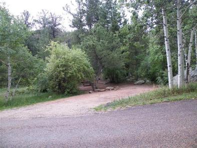
Nestled among aspen and tall Douglas fir trees, St. Charles Campground is in a quiet part of the Lake Isabel Recreation Area. Located on the banks of St. Charles Creek, the campground is popular with campers who enjoy the sounds of water tumbling through the shaded boulders.

Recreation

Lake Isabel is stocked with brown and rainbow trout. The accessible lakeshore path provides ample fishing spots. Brook trout can be found in St. Charles Creek. Several trails begin at the recreation area. Hiking opportunities include the Snowslide Trail and the Cisneros Trail. Both trails are also open to motorcycles, and Cisneros is a challenging ATV route.

Facilities

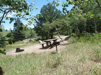
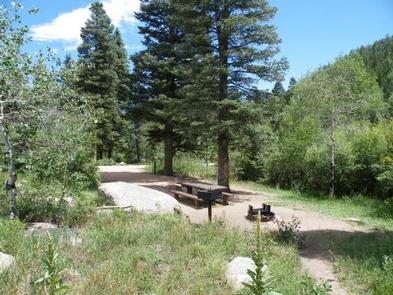
Campsites can accommodate small trailers; tent pads are provided for tent campers. Each campsite contains a bear-proof food locker, picnic table, fire ring and fire pedestal. Campground amenities include accessible vault toilets, drinking water from a hand pump, and bear-proof trash dumpsters. Firewood is sold by the on-site campground host.

Natural Features

The campground sits a mile west of Lake Isabel in the Wet Mountains, a beautiful range in the San Isabel National Forest. At an elevation of 8,600 feet, Lake Isabel was designed and constructed in the 1930s as a recreational haven from the dusty plains far below. Rugged mountain peaks in the area provide water for the abundant wildlife and fish populations.

Nearby Attractions

A nearby lodge offers paddle and rowboat rentals, groceries and a restaurant. Golf courses are about 15 minutes away.

Reservation

More from CampingHiking.net:

KINNIKINNICK, California Campground Images, Info & Reservations

Directions Take Highway 168 east from Clovis to Shaver Lake. Continue through Shaver Lake to Huntington Lake. Continue around Huntington Lake for 1.3 miles to Kinnikinnick Campground (located adjacent to Catavee Campground). Phone 559-893-2111 Activities BOATING, CAMPING, INTERPRETIVE PROGRAMS, FISHING, HIKING, WATER SPORTS, SWIMMING SITE Keywords KINN,HUNTINGTON LAKE,SIERRA NF –

HIGH VIEW, Texas Campground Images, Info & Reservations

Directions From Ennis, Texas: From Interstate 45, exit onto U.S. Highway 287 Bypass (Exit #247). Travel 4.5 miles and exit at the Bardwell Lake exit sign. Turn left onto Highway 34 and go 2.5 miles southwest. After crossing the Bardwell Lake bridge, take the first left onto High View Park

WATAUGA POINT RECREATION AREA, Tennessee Campground Images, Info & Reservations

Directions From Elizabethton, take US 19E/321 south for five miles to Hampton. Turn left on US 321/TN 67 south for six miles, then turn left into Watauga Point.  Phone 423-735-1500 Activities BOATING, FISHING, HIKING, KAYAKING, CANOEING, STAR GAZING, NON-MOTORIZED BOATING, WATER ACCESS, SCENIC DRIVE Keywords WATAUGA POINT RECREATION AREA PAVILION

RATTLESNAKE, Idaho Campground Images, Info & Reservations

Directions From Crouch, travel north on Forest Road 698 approximately 14 miles to the campground, which is located on the left-hand side of the road. Phone 541-351-1182 Activities BIKING, CAMPING, FISHING, HIKING, HUNTING, PICNICKING Keywords RATT,BOISE NF – FS Related Link(s) Rec Area Info & Images Forest Service Concessionaire Idaho

BROYLES, Georgia Campground Images, Info & Reservations

Directions From Interstate 85, take exit 11 to Highway 24 headed towards Anderson, SC. Turn right onto Hattens Ford Road and follow signs to the facility. 900 SMYZER ROAD, TOWNVILLE, SC 29689 Phone 888-893-0678 HARTWELL PROJECT OFFICE Activities BOATING, FISHING, PICNICKING, DAY USE AREA, SWIMMING SITE, SWIMMING, WATER ACCESS Keywords