DYERS CREEK, TN Campground Reservation, Info, Images, Map, Directions

DYERS CREEK, Tennessee Campground Images, Info & Reservations

Directions

From Nashville, Tenn, take I-24 West to the Clarksville Exit 8. Take US-79S for 46 miles to Dyers Creek Recreation Area.

Phone

931-232-7724 DOVER OFFICE; 270-362-4236 LAKE BARKLEY RESOURCE MANAGERS OFFICE

Activities

BOATING, HISTORIC & CULTURAL SITE, FISHING, VISITOR CENTER, DAY USE AREA

Keywords

DYER,LAKE BARKLEY,BARKLEY LOCK & DAM

Related Link(s)

Rec Area Info & Images

Tennessee State Road Conditions

Tennessee State Tourism

Overview

Dyer’s Creek boasts fantastic views of on the sparkling Lake Barkley in the wooded rolling hills of Tennessee. Whether it’s a family picnic and a BBQ with friends, the recreation area provides the perfect setting for a relaxing get-together.

Recreation

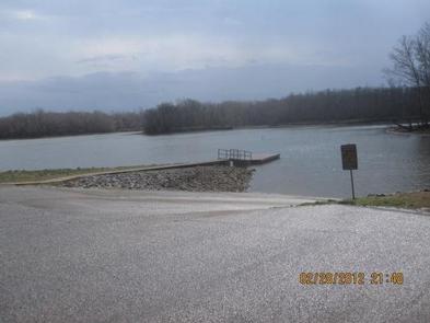
Visitors here enjoy boating, fishing, wildlife watching and swimming.

Bring the binoculars and search for wildlife like the white-tailed deer, raccoons and bald eagles. Fishing is popular, and during warm months bass and catfish are abundant.

Facilities

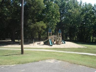
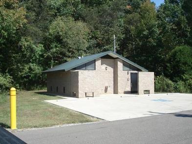
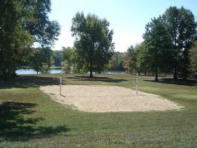
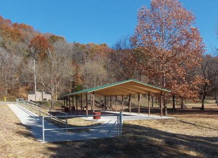
The park provides a playground, volleyball court, flush toilets and a boat ramp. The shelter accommodates up to 100 people and 50 vehicles. Ample paved parking is also available.

Natural Features

Lake Barkley, the westernmost lake on the Cumberland River is connected by canal to Kentucky Lake, forming one of the greatest freshwater recreation complexes in the country.

Between both lakes sits the Land Between the Lakes National Recreation Area, the largest inland peninsula in the United States. Here visitors have access to boat ramps, many miles of hiking trails, wildlife viewing and off highway vehicle riding.

Nearby Attractions

Visit the Lake Barkley State Resort Park for miles of hiking trails and horseback riding stables.

Reservation

More from CampingHiking.net:

WALLACE CREEK, Mississippi Campground Images, Info & Reservations

Directions From I-55, take exit 233 and head east on Country Road 36. After about 2.5 miles follow the signs to the campground. Phone 662-563-4571 Activities BOATING, CAMPING, FISHING, HIKING, SWIMMING SITE Keywords WALC,ENID LAKE – MS,LIPE’S BLUFF 43-72,PINEY WOODS 1-42,HICKORY RIDGE,MCCURDY POINT,WOODPILE 73-99,ENID LAKE Related Link(s) Rec Area Info

NORDHEIMER GROUP SITES, California Campground Images, Info & Reservations

Directions From Highway 96, turn onto Salmon River Road/Forest Highway 93 and continue about 13 miles to the campground. Phone 530-627-3291 Activities BIKING, BOATING, CAMPING, FISHING, HIKING, SWIMMING SITE Keywords NORD,Crystal Springs Group Sites,SIX RIVERS NF -FS Related Link(s) Rec Area Info & Images California State Tourism California State Road

WINNIE DAM CAMPGROUND, Minnesota Campground Images, Info & Reservations

Directions From Deer River, Minnesota, take Highway 2 west for one mile. Turn right on Highway 46 and go 12 miles. Turn left on Itasca County 9 and continue 2 miles, then turn left at signs and follow to the campground. Phone 218-326-6128 Activities CAMPING Keywords LAKW,WINNI DAM CAMPGROUND,WINNI CAMPGROUND,MISSISSIPPI

MARTEN LAKE CABIN, Alaska Campground Images, Info & Reservations

Directions The cabin is located at the north end of Marten Lake, southeast of Wrangell. The lake is on the mainland (at an elevation of 178 feet) above Blake Channel and the Bradfield Canal. This cabin is accessible by float plane only and is 25 miles by air from Wrangell.

LONGWOOD PARK, Virginia Campground Images, Info & Reservations

Directions The physical address for Longwood Park is: 13500 Hwy 15, Clarksville, VA 23927. It is located 7 miles south of Clarksville, VA. Phone 434-374-2711 IN SEASON ONLY; ALL OTHERS CALL 434-738-6143 Activities BOATING, CAMPING, FISHING, PICNICKING, WILDLIFE VIEWING, SWIMMING SITE, CANOEING Keywords LONG,BUGGS ISLAND,JOHN H KERR DAM Related Link(s)