EAST FORK (TX), TX Campground Reservation, Info, Images, Map, Directions

EAST FORK (TX), Texas Campground Images, Info & Reservations

Directions

From Wylie, TX, take State Highway 78 North to Eubanks Lane. Turn left onto Eubanks, stay to the right at the fork in the road (onto Forrest Ross Road) and continue to the stop sign at the intersection of Forrest Ross Road and Skyview Drive. Continue straight into East Fork Park.

Phone

972-442-3141

Activities

BOATING, CAMPING, FISHING

Keywords

EAF2,LAVON LAKE,LAKE LAVON,LAVON LAKE

Related Link(s)

Rec Area Info & Images

Texas State Road Conditions

Texas State Tourism

Overview

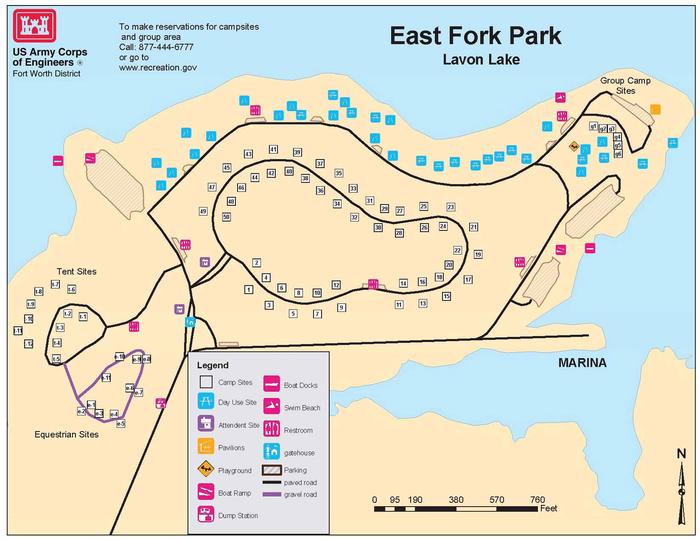
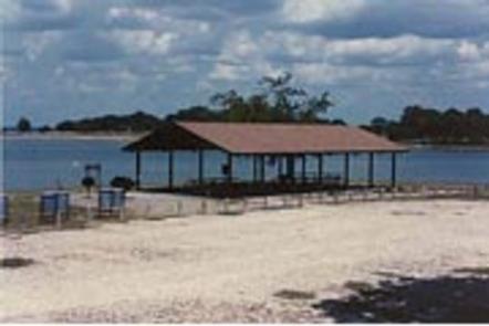
East Fork Campground, on the southern shores of Lavon Lake, is a popular escape for city dwellers in the Dallas, Texas area or for any visitors passing through the Northern Texas region. The campground boasts everything including RV campsites, tent campsites, equestrian campsites, a group shelter and a swimming beach to keep visitors entertained during their stay.

Recreation

Boating and fishing are consistently popular activities for lake-goers. Horseback riding and hiking is great along the Trinity Trail, with a trailhead beginning adjacent to the East Fork campground.

Facilities

The campground offers 50 sites with water and electric hookups, plus 12 tent-only sites. There are not sewer hook-ups at the campsite, but there is a dump station located near the park entrance. It’s the only campground at Lavon Lake with 50-amp electricity. Extra conveniences include hot showers and two boat ramps. The group campground is available year-round and fits 175 guests. Horses are allowed at the Equestrian Loop, and each equestrian site has a portable horse stall.

Natural Features

Lavon Lake, in northern Texas, flows from the East Fork tributary of the Trinity River. Its surface area spans 21,400 acres and the maximum lake depth of around 59 ft..

Nearby Attractions

The Heard Natural Science Museum and Wildlife Sanctuary features natural history exhibits and nature trails.

Reservation

More from CampingHiking.net:

NEMO LANDING, Missouri Campground Images, Info & Reservations

Directions From Springfield, MO, take US 65 north past Louisburg, MO, to NN Highway. Follow NN Highway south to Nemo, MO. Turn south at the 4-way stop and find the entrance to Nemo Landing on the left side of the highway. Phone 417-993-5529 Activities CAMPING, SWIMMING SITE Keywords NEMO,POMME DE

SAN ANTONIO CAMPGROUND, New Mexico Campground Images, Info & Reservations

Directions From Jemez Springs, New Mexico, travel 9 miles north on New Mexico State Road 4 and along the Jemez Mountain Trail National Scenic Byway, then take New Mexico State Road 126 for 2 miles to campground. Phone 575-829-3535 Activities CAMPING, FISHING, HIKING, WILDLIFE VIEWING Keywords None Related Link(s) Rec

Rim Campground, Arizona Campground Images, Info & Reservations

Directions Located on Road 300 approximately 1 mile off of High 260. Phone 928-535-9859 Activities BOATING, CAMPING Keywords Related Link(s) Rec Area Info & Images Arizona State Road Conditions Arizona State Tourism Overview Rim Campground is situated close to the edge of the Mogollon Rim. Spectacular 100-mile views are seen

PEARCH CREEK CAMPGROUND, California Campground Images, Info & Reservations

Directions From Orleans, California, follow State Highway 96 north approximately 1.5 miles to the campground. Phone 530-627-3291 Activities BIKING, BOATING, CAMPING, FISHING, HIKING, HUNTING, VISITOR CENTER, WATER SPORTS, WILDLIFE VIEWING, SWIMMING SITE Keywords PEAR,SIX RIVERS NF -FS Related Link(s) Rec Area Info & Images California State Road Conditions California State