
Directions
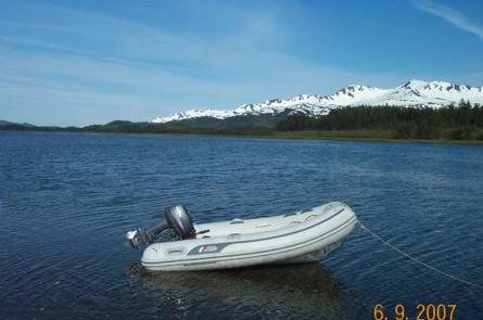
Access to the cabin is by float plane (40 minutes from Cordova, 60 minutes from Seward) or boat (65 miles from Cordova, 70 miles from Whittier, 100 miles from Seward). Best access to the cabin is at high tide. Click here for local tide tables.
Winter access may be difficult due to pan ice in the bay, and guests should be prepared for extended stays due to poor weather. Please contact the Cordova Ranger District at (907) 424-7661, for an update on conditions prior to arrival.
Phone
1 (907) 424-7661
Activities
BOATING, CAMPING, FISHING, HUNTING, WILDLIFE VIEWING
Keywords
POR1,CHUGACH NF – FS
Related Link(s)
Overview
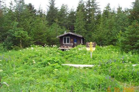
Port Chalmers Cabin offers guests access to a variety of recreational activities, relaxation and a unique lodging experience on Montague Island in southcentral Alaska. The remote site offers a scenic setting for hiking, fishing, hunting, and wildlife viewing all within steps of the cabin. Access to the cabin is by float plane or boat from Cordova, Seward or Whittier. Visitors are responsible for their own travel arrangements and safety, and must bring several of their own amenities.
Recreation
Anglers can fish for pink, chum, and coho salmon in the bay and streams around the cabin. Some pink salmon spawn in the tiny creeks around the cabin.The main spawning stream in the area is Chalmers River, about a mile to the north across the inlet. Chum and pink salmon can be found in this waterway. Rockfish and halibut can be found in kelp beds and on the rocky bottom area in the open ocean outside the bay.
Hunters can take advantage of a long hunting season on the island and in the surrounding national forest. Bear season occurs during spring and fall, while deer season begins in late summer and lasts through late fall.
Facilities
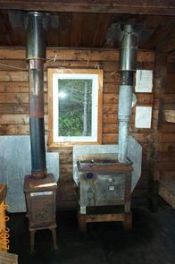
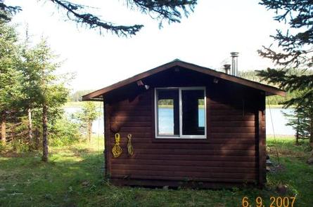
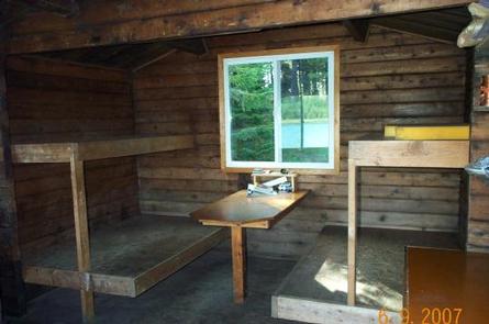
The rustic, 12-by-14 cabin has wooden bunks, without mattresses, that can sleep up to six people. It is also equipped with a table, wood stove, oil stove, a rainwater catchment barrel, axe, saw, splitting maul and an outdoor pit toilet.
The cabin does not have running water or electricity. Guests must bring their own water, food, sleeping bags, sleeping pads, cook stoves, matches, cut firewood, cooking gear/utensils, a light source, No.1 stove oil, toilet paper, first aid kit and garbage bags
Click here for more cabin details.
Natural Features
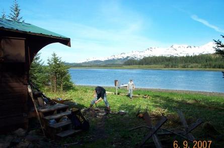
Montague Island lies in the Gulf of Alaska, at the entrance to Prince William Sound. The cabin is located in a grassy clearing at the edge of a dense spruce-hemlock forest interspersed with muskeg openings. It is considered to be within the tidal bay area at the southern end of Port Chalmers on the northwest side of the island. Low hills rise from the surrounding area. In the distance, snow drapes higher peaks.
Wildlife in the area abounds, including migratory waterfowl, Sitka black-tail deer and brown bears (learn more about bear safety).
Nearby Attractions
Guests should be aware that the cabin sits within the Chugach National Forest, however some of the land on Montegue Island is owned by the Chugach Alaska Corporation. Access to these lands requires permission from the corporation. Contact the Cordova Ranger District at (907) 424-7661 for a detailed map of land ownership in the area.