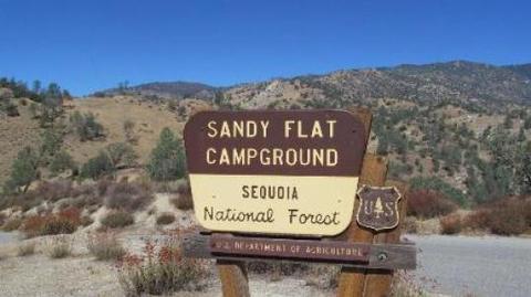
SANDY FLAT, CA Campground Reservation, Info, Images, Map, Directions

SANDY FLAT, California Campground Images, Info & Reservations

Directions

From Highway 99, take Highway 178 east for 4 miles. Turn right on Borel Road, then right onto the Old Canyon Road. Continue about 2 miles, then turn right into Sandy Flats Campground.

Phone

760-376-1815

Activities

CAMPING, FISHING

Keywords

SANF,Sandy Flat

Related Link(s)

Rec Area Info & Images

California State Road Conditions

California State Tourism

Forest Service Concessionaire

Overview

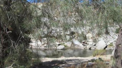
Sandy Flat Campground is set back from the Lower Kern River at an altitude of 2,300 feet near the town of Lake Isabella. Campsites are a short walk from the river, offering countless recreational opportunities for visitors.

Recreation

Hiking, trout fishing, river wading and floating are popular pursuits. The Hobo Fishing Trail, a short walking trail, is nearby.

Click here to learn more about the Lower Kern River, including safety and permitting requirements and a listing of local outfitters.

Facilities

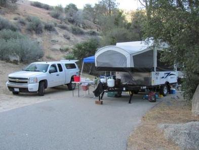
Campsites are set along one loop in largely open sites. Large boulders, relics of the ice age, are scattered throughout the campground. River access is in the day camp area. Drinking water, picnic areas and vault toilets are provided.

This facility is operated by Sequoia Recreation, a division of California Land Management and comments are welcome; comment forms are available from campground hosts or online.

Natural Features

The Sequoia National Forest, located at the southern end of the Sierra Nevada in central California, takes its name from the giant sequoia, the world’s largest tree, which grows in more than 30 groves on the Forest’s lower slopes.

The Forest comprises about 1.1 million acres, and elevations range from about 1,000 to 12,000 feet, creating precipitous canyons and mountain streams with spectacular waterfalls such as Salmon Creek Falls and Grizzly Falls.

Nearby Attractions

The Giant Sequoia Mercantile offers a wide variety of books, maps, gifts, local art, camping supplies and other merchandise.

Reservation

More from CampingHiking.net:

LOS PRIETOS, California Campground Images, Info & Reservations

Directions From Highway 101 in Santa Barbara, turn east onto Highway 154 and continue about 11 miles. Turn onto Paradise Road and travel about 3 miles to the campground. Phone 805-434-1996 Activities BIKING, CAMPING, FISHING, SWIMMING SITE Keywords LOSP,Santa Ynez Recreation Area,Los Padres National Forest,LOS PADRES NF -FS Related Link(s)

ALLRED FLATS GROUP PICNIC SITE, Wyoming Campground Images, Info & Reservations

Directions From Afton, Wyoming, take Highway 89 south for approximately 21 miles over Salt Pass and look for a brown sign signaling the right-hand turn for Allred Flats Campground. The picnic area is on the left, just before the campground entrance kiosk. Phone 307-828-5100 Activities BIKING, CAMPING, FISHING, HIKING, WILDLIFE

CASTLE ROCK GROUP CAMPGROUND, Oregon Campground Images, Info & Reservations

Directions From Hebo, Oregon travel south on Highway 22, 4.2 miles. Location is on the right. Phone 503-392-5100 Activities HIKING, SWIMMING Keywords Related Link(s) Rec Area Info & Images Oregon State Tourism Oregon State Road Conditions Overview Located on Three Rivers, this group campground is ideal for family gatherings and

JARVIES BOAT IN GROUP, Utah Campground Images, Info & Reservations

Directions Cedar Springs Marina is the closest boat ramp to Jarvies. Jarvies Canyon is the first canyon west and a little north of the marina and is only accessed by boat. From Vernal, Utah, take U.S. 191 north 42 miles. Turn north onto Forest Road 183 and travel approximately 2

MONTPELIER CANYON CAMPGROUND, Idaho Campground Images, Info & Reservations

Directions The campground is located three miles east of Montpelier, Idaho, on U.S. Highway 89. Phone 541-351-1182 Activities BIKING, BOATING, CAMPING, FISHING, HIKING, HORSEBACK RIDING, WILDLIFE VIEWING Keywords MTPC,MONTPELIER CAMPGROUND,CARIBOU-TARGHEE NF – FS Related Link(s) Rec Area Info & Images Idaho State Road Conditions Idaho State Tourism Overview Montpelier Canyon