
Directions
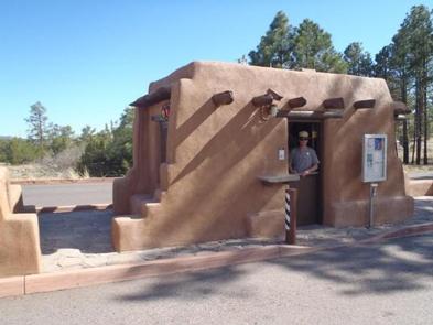
From Santa Fe, take Saint Francis Drive (Highway 84/285) north toward Los Alamos. After passing Pojoaque, merge right onto New Mexico 502 to Los Alamos. Continue up 502 toward Los Alamos. Bear right and exit onto New Mexico 4 toward White Rock. Continue for 12 miles, passing White Rock. Bandelier’s entrance is on your left. Enter here and purchase your entrance pass at the entrance station. Continue 6 more miles up Route 4, Ponderosa Campground is on your left. Travel distance from Santa Fe is 1 hour.
From Taos, take New Mexico 68 (Paseo del Pueblo Sur) south for 47 miles. In Espanola, turn right onto Fairway. Turn left at next stoplight on Highway 84/285. At stoplight near the Ford Dealership, turn right on Highway 30. Follow 30 through Santa Clara Pueblo to junction with Highway 502. Merge right onto 502 toward Los Alamos. Follow directions above. Travel distance from Taos is 1.5 hours.
Phone
(505) 672-3861
Activities
CAMPING, HIKING, PICNICKING, WILDLIFE VIEWING
Keywords
Bandelier
Related Link(s)
New Mexico State Road Conditions
Overview
For large groups coming to Bandelier National Monument, Ponderosa Campground is an ideal place to stay. Located 6 miles from the main park entrance, the campground is just a short drive from the main visitor center, the Frijoles Canyon Shuttle System (mid-May to mid-October) and the adjacent town of Los Alamos. Ponderosa Campground is open year-round. The canyon and most of the park’s trails are only accessible by shuttle bus during designated periods, but guests can access those areas by vehicle the remainder of the year. Though open all year, water is only available from mid-May to mid-October.
Recreation
Hikers can access one trail directly from the facility. The Ponderosa Trail descends into the park through ponderosa pine forest and leads 8 miles through Frijoles Canyon to the visitor center and Main Loop Trail. The visitor center and over 70 miles of trails can be accessed by car part of the year, however Frijoles Canyon, the visitor center, and some trails may only be accessed by shuttle bus from mid-May to mid-October. Most visitors begin their exploration of Bandelier with a walk on the Main Loop Trail. This short 1.2 mile loop trail starts from the visitor center and leads through excavated archeological sites on the floor of Frijoles Canyon. A portion of this trail is accessible. Other trails in this area include the 3-mile round-trip Falls Trail to beautiful Upper Falls, and various trails of different lengths and difficulties leading up to the mesa tops. Although rock climbing is prohibited in Bandelier, many popular climbs are within a short drive up Route 4 into the Jemez Mountains.
Facilities
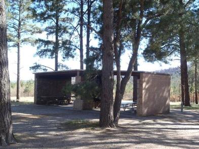
Vault toilets, drinking water, a picnic shelter and picnic tables are provided at this facility. Food storage lockers and campfire rings are available. These sites are tent-only, but one RV per site can be accommodated in the parking area. No hookup campsites are available. Each site can accommodate between 10 and 50 people. Sites can be reserved for large group picnics, however the fee and process is the same as reserving the site for an overnight stay. Checkout time for the campround is 11:30 a.m. – please do not arrive for a group picnic prior to that time.
Natural Features
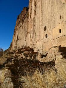
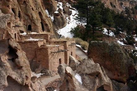
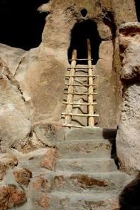
Bandelier National Monument protects over 33,000 acres of rugged, beautiful canyon and mesa country as well as evidence of a human presence here going back over 11,000 years. Petroglyphs, dwellings carved into the soft rock cliffs, and standing masonry walls pay tribute to the early days of a culture that still survives in the surrounding communities. The park is home to over 55 species of mammals including mule deer, Abert’s squirrels, mountain lions and 16 species of bats. Black bears have also been seen in the park. Birds such as Steller’s jays, canyon towhees and mountain chickadees stay year-round, whereas turkey vultures, western tanagers and black-headed grosbeaks are summer-only residents.
Nearby Attractions
The town of Los Alamos has shopping, museums, amenities, a movie theater, ice rink and ski hill. The YMCA and a swimming pool both have showers for campers. Nearby Department of Energy and Forest Service lands provide trails which accommodate pets.