HOOD CREEK CAMPGROUND, MONTANA Campground Reservation, Info, Images, Map, Directions

HOOD CREEK CAMPGROUND, Montana Campground Images, Info & Reservations

Directions

From Main Street in Bozeman, travel south on 19th Avenue for 7 miles, to the paved Hyalite Canyon Road. Turn left and continue 10 miles to the campground.

Phone

(406)646-1012

Activities

BIKING, BOATING, CAMPING, FISHING, HIKING, PICNICKING, WILDLIFE VIEWING, DAY USE AREA, PHOTOGRAPHY, SWIMMING, MOUNTAIN BIKING, OFF ROAD VEHICLE TRAILS, KAYAKING, CANOEING, BERRY PICKING, STAR GAZING, BIRDING, WATER ACCESS, BACKPACKING, MUSHROOM PICKING

Keywords

HOOC,GALLATIN NF – FS

Related Link(s)

Rec Area Info & Images

Forest Service Concessionaire

Montana State Tourism

Montana State Road Conditions

Overview

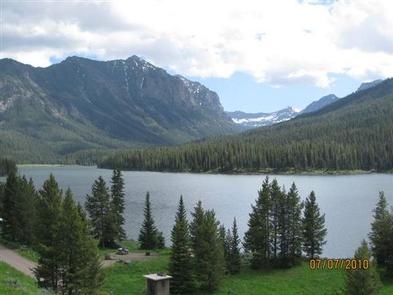
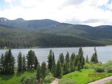
Hood Creek Campground is located next to scenic Hyalite Reservoir, on the Bozeman Ranger District of the Gallatin National Forest. It is 17 miles south of the city of Bozeman, Mont. The surrounding area offers many outdoor recreational opportunities, including boating, canoeing, fishing, hiking and climbing.

Recreation

Hyalite Reservoir offers many recreational activities, including boating, canoeing and fishing. Anglers fish for Yellowstone cutthroat, Arctic grayling and brook trout. Hyalite Creek offers fishing as well.

Many hiking trails are found in Hyalite Canyon, including the popular Hyalite Peak Trail. This 7.5-mile one-way trail gains 3,450 feet in elevation as is climbs past numerous waterfalls to the beautiful Hyalite Lake and Hyalite Peak.

Facilities

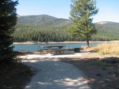
The campground offers sites for both overnight camping and day-use picnicking. A GROUP AREA (SITE 28) for overnight camping is also available for reservation, and can accommodate up to 80 people.

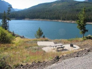
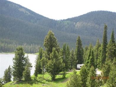
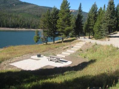
Picnic tables and campfire rings are provided, as are vault toilets, drinking water and trash collection. A boat ramp is located on-site. Roads and parking spurs within the campground are gravel. Firewood is available for $6.00 per bundle.

Natural Features

The campground is situated on the banks of scenic Hyalite Reservoir, at an elevation of 6,700 feet. Some campsites lie in open meadows along the shoreline, while others are located among scattered pine and fir trees.

Reservation

More from CampingHiking.net:

BULLTOWN CAMP, West Virginia Campground Images, Info & Reservations

Directions From North of Charleston, WV and I-79, take Exit 67 (Flatwoods) and travel north on U.S. Highway 19 for 10 miles. Follow signs into campground. From Clarksburg, WV and I-79, take Exit 91 (Roanoke), travel south on U.S. 19 for 28 miles. Follow signs into campground. Physical Address: Bulltown

BLUEBILL CAMPGROUND, Oregon Campground Images, Info & Reservations

Directions From Reedsport, Oregon, take Highway 101 south for 22 miles to the Horsfall Dunes and Beach road sign; turn right and follow signs. From Coos Bay/North Bend, Oregon, take Highway 101 north for about 2 miles to the Horsfall Dunes and Beach road sign, turn left and follow signs.

DOVER, Tennessee Campground Images, Info & Reservations

Directions From Nashville, or St.Louis , take I-24 Clarksville, take Exit 8 for TN 237 W. 2.4 Mi., Right onto Warfield Blvd 1.6 Mi. continue onto 101st Airborne PKWY for 6.3 Mi. contine onto TN 347 -PKWY for 4.5 Mi. Turn right onto US 79 S. for 24.2 Mi. Turn

GAMALIEL, Arkansas Campground Images, Info & Reservations

Directions From Mountain Home, AR, travel 9 miles east on US 412/62, then 5 miles north on SR 101, then 3 miles southeast on CR 42. Follow signs into campground. Phone 870-467-5680 Activities BOATING, CAMPING, SWIMMING SITE Keywords GAMA,NORFORK LAKE,NORFORK LAKE Related Link(s) Rec Area Info & Images Arkansas State

NORTH OVERLOOK CAMP, Iowa Campground Images, Info & Reservations

Directions 1007 Hwy T-15 Pella, Iowa From Pella, Iowa, take County Highway T-15 southwest for 3 miles, then follow signs to the campground. Phone 641-828-7522 Activities BIKING, BOATING, CAMPING, FISHING, HIKING, VISITOR CENTER, DAY USE AREA, SWIMMING SITE Keywords NORC,LAKE RED ROCK Related Link(s) Rec Area Info & Images Iowa

CADDO DRIVE, Arkansas Campground Images, Info & Reservations

Directions From Interstate 30 take exit 78. Merge onto State Highway 7 north for 6 miles. Turn left onto Edgewood Road and continue 3 miles to Caddo Drive. Phone 870-246-5501 Activities BOATING, CAMPING, FISHING, WILDLIFE VIEWING, SWIMMING SITE Keywords CADV,DEGRAY LAKE,DEGRAY LAKE,CADDO,DeGray Lake Related Link(s) Rec Area Info & Images