TWIN KNOBS CAMPGROUND, KY Campground Reservation, Info, Images, Map, Directions

TWIN KNOBS CAMPGROUND, Kentucky Campground Images, Info & Reservations

Directions

Coming from Lexington, Kentucky, on I-64, take exit 133. Turn right at the top of the exit ramp to proceed south on KY-801. Proceed 8.4 miles on 801. The campground entrance is on the right.

Phone

606-780-7818

Activities

BIKING, BOATING, CAMPING, INTERPRETIVE PROGRAMS, FISHING, HIKING, WATER SPORTS, WILDLIFE VIEWING, DAY USE AREA, SWIMMING SITE

Keywords

TWKN,CAVE RUN LAKE,CAVE RUN PARK,TWIN KNOBS,DANIEL BOONE NF-FS

Related Link(s)

Rec Area Info & Images

Forest Service Concessionaire

Kentucky State Road Conditions

Kentucky State Tourism

Overview

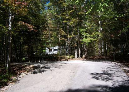
Nestled on the shores of Cave Run Lake, this camp is part of the larger Twin Knobs Recreation Area. There are more than 200 sites spread out over 10 loops under a dense forest of mixed conifer and deciduous trees.

The recreation area includes two reservable group picnic areas. Group camping is also available.

Recreation

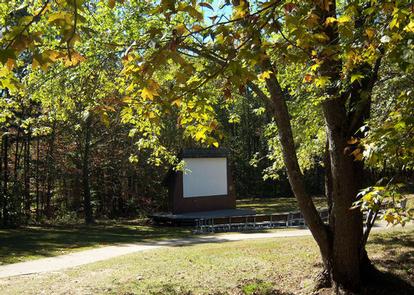
Summer amphitheater programs and scheduled campground activities provide family fun and entertainment. The campground also has volleyball courts, basketball hoops and horseshoe pits.

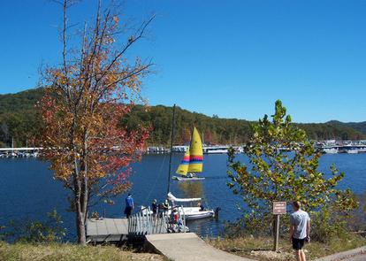
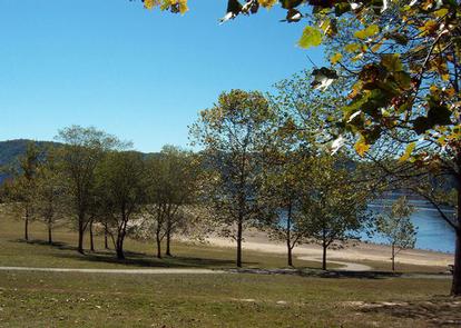
There is a boat ramp and beach. Popular lake activities include fishing, swimming, motor boating, windsurfing, sailing and water skiing.

Scenic foot trails include the 2.5-mile Twin Knobs Shoreline Trail and the 1.5-mile Knob Overlook Trail.

Facilities

There is a variety of different camp sites that include paved spurs that can accommodate any size RV, picnic tables, fire rings and grills. Some sites have electric hookups.

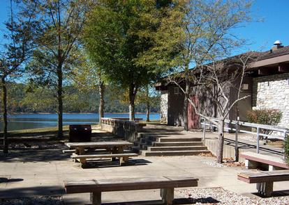
Facilities include bathhouses with showers, drinking water and flush toilets. The bathhouses and some picnic areas are accessible.

Natural Features

The Daniel Boone National Forest embraces some of the most rugged terrain west of the Appalachian Mountains. The forest lies within the Cumberland Plateau, where steep forested slopes, sandstone cliffs and narrow ravines characterize the land in this region.

Cave Run Lake is in the Cumberland District in the northernmost part of the forest. The lake is surrounded by the rolling hills of northeastern Kentucky.

Nearby Attractions

The Morehead Office Visitor Center offers information about the Daniel Boone National Forest in addition to interpretive exhibits. A popular attraction within the Daniel Boone National Forest is the Red River Gorge Geological Area, which features more than 100 natural sandstone arches.

Reservation

More from CampingHiking.net:

LOWER PENSTEMON, Idaho Campground Images, Info & Reservations

Directions Travel south on Twin Falls County Road G3 which becomes Forest Road 515, commonly known as Rock Creek Road, for approximately 27 miles from Hansen. Phone 208-678-0430 Activities BIKING, CAMPING, HIKING, HORSEBACK RIDING, HUNTING, WILDLIFE VIEWING Keywords LOWP,SAWTOOTH NF – FS Related Link(s) Rec Area Info & Images Idaho

THOMPSON FLAT, Idaho Campground Images, Info & Reservations

Directions From Interstate 84, take exit 216 and follow State Highway 77 south for approximately 18 miles, through the towns of Declo and Albion, to Howell Canyon Road. Turn west at the Pomerelle Ski Area sign and drive seven miles up the canyon on Howell Canyon Road. The road is

CUMMINGS CABIN, Montana Campground Images, Info & Reservations

Directions The cabin is located 8.5 miles east of Lincoln, Montana and can be reached via Hogum Creek Road, which is approximately 6 miles east of Lincoln on Highway 200. Follow Hogum Creek Road to the junction of Black Diamond Road and Lower Hogum Creek Road. Lower Hogum Creek Road

EAST DAVIS CAMPGROUND, Oregon Campground Images, Info & Reservations

Directions From Crescent, OR: Travel 8.8 miles west on County Road 61, then 7.7 miles north on Highway 46, then 2.6 miles west on Forest Road 4600 850. Phone 541-323-1746 Activities CAMPING Keywords Related Link(s) Rec Area Info & Images Oregon State Tourism Oregon State Road Conditions Overview East Davis

CANEBRAKE HORSE CAMP, North Carolina Campground Images, Info & Reservations

Directions The address is 616 McLeans Creek Road, Troy, NC 27371. From Troy, North Carolina, take State Highway 109 north for approximately 10 miles. Turn left onto Mullinix Road (State Highway 1154) and travel approximately 1.5 miles to a stop sign and “T” intersection. Turn right, and travel about 0.25

LEDGEFORK, Utah Campground Images, Info & Reservations

Directions From Salt Lake City: From I 15, take I 80E past Park City to either Hwy 189 or Wanship. On 189, travel SE to Kearns Blvd/SR 248. Continue east on SR 248 to Browns Canyon Rd. Travel E/NE on Browns Canyon until it connects with SR 32 just north