BELTON LAKEVIEW PARK, TX Campground Reservation, Info, Images, Map, Directions

BELTON LAKEVIEW PARK, Texas Campground Images, Info & Reservations

Directions

From Interstate 35 in Belton, Texas take exit onto Road 317 (North Main Street). Turn left onto Farm-to-Market Road 439 (Lake Road), and travel west about four miles to the park.

Phone

254-939-2461

Activities

BOATING, CAMPING, FISHING, PICNICKING

Keywords

BELT,OVERLOOK PAVILION (BELTON LK),BELTON GROUP USE AREA,FRANKS PAVILION,BELTON PARK,BELTON LAKE

Related Link(s)

Rec Area Info & Images

Texas State Tourism

Texas State Road Conditions

Overview

Belton Lakeview Park has two reservable group day-use areas along the lower shore of Belton Lake, providing some of the best fishing and boating in Central Texas.

The facility is perched on a bluff overlooking Belton Lake and Dam, a year-round scenic location for group picnics and large gatherings. The site offers many amenities, such as flush toilets, water and electric hookups, a playground and a two-lane boat ramp, ensuring your stay is both comfortable and enjoyable.

Belton Lake was created by the U.S. Army Corps of Engineers with the construction of Belton Dam in 1954. The 12,300-acre lake is located on the Leon River, just upstream of the confluence of the Leon River and the Little River.

Recreation

Belton Lakeview Park is a great destination for boaters and anglers. Popular fish species include hybrid striped bass, largemouth bass, white bass, catfish and sunfish. Guests can also make use of the playgrounds and nature trails.

Facilities

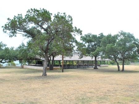
The Franks area holds 120 people, and Overlook can accommodate 150 people. They each provide a large pavilion, playground, restrooms and hookups.

Overlook is next to Belton Dam and Franks is 1/4 mile west of the dam near the marina. There is no direct lake access from the group areas, but the boat ramp is nearby within the park.

Natural Features

The group use areas are along the forested shoreline of Belton Lake; there is plenty of shade provided by trees and picnic shelters. The sites are not directly on the water, but provide a view of the lake.

The lake area is a habitat for deer, wild turkey and water birds such as Great Blue herons, ducks, geese, many species of songbirds and even an occasional bald eagle.

Nearby Attractions

Belton Lake is located adjacent to the Fort Hood Army Base, which has several points of interest for the military buff. The mural painted on the spillway wall of Belton Dam depicts the history of the Bell County area.

Miller Springs Nature area, located on the North end of Belton Dam across from Live Oak Ridge park, offers great hiking opportunities.

Reservation

More from CampingHiking.net:

ANDERSON ROAD, Tennessee Campground Images, Info & Reservations

Directions From downtown Nashville, TN, take I-40 east for 5 miles to exit 219. Turn right on Stewarts Ferry Pike and continue straight on Bell Road for 5 miles. Turn left on Smith Springs Road, then left on Anderson Road. The campground is ahead about 1 mile on the left

SILTCOOS SAND CAMPING, Oregon Campground Images, Info & Reservations

Directions From Florence Oregon, travel 7 miles south on Highway 101 to the Siltcoos Beach Access Road. Turn west on Siltcoos Beach Access Road and proceed 1 mile 1.5 miles to Driftwood II Campground on the right. The Sand Access is within the Campground. Phone 541-271-6000 Activities CAMPING, FISHING, HIKING,

HIRZ MOUNTAIN LOOKOUT, California Campground Images, Info & Reservations

Directions From Redding, California, take Interstate 5 north approximately 20 miles to Gilman Road, exit 698. Turn right and follow Gilman Road approximately 5 miles to road 35N04. Turn left on the road 35N04. This steep, rocky, dirt road is not recommended for low clearance passenger vehicles. Travel approximately 5

GROUSE VALLEY, California Campground Images, Info & Reservations

Directions The county road from Springville to the cabins is narrow with many sharp turns, and vehicles over 22 feet are not advised. Take Highway 190 east from Porterville to Springville. After passing through Springville, take a left on Balch Park Road. Drive approximately 10.5 miles, then turn left onto

COLES POINT, Virginia Campground Images, Info & Reservations

Directions From I-64 at Exit 16A or 16B in Covington, follow signs to U.S. Highway 220 and travel north about 5.5 miles. Turn left on State Road 687/Jackson River Road and travel about 3.2 miles. Turn left on State Road 641/Indian Draft Road, which soon becomes State Road 666. Travel

BLUE BAY, Oregon Campground Images, Info & Reservations

Directions From Sisters, travel approximately 13 miles northwest on Highway 20/126. Turn left onto Forest Road 2070 (Suttle Lake Campgrounds). Travel just less than 1/2-mile to Blue Bay entrance on the right. Phone 541-323-1746 Activities BOATING, CAMPING, INTERPRETIVE PROGRAMS, FISHING, HIKING Keywords BLBA,SUTTLE LAKE CAMPGROUND,DESCHUTES NF – FS Related Link(s)