STEVENS CREEK CAMPGROUND, CO Campground Reservation, Info, Images, Map, Directions

STEVENS CREEK CAMPGROUND, Colorado Campground Images, Info & Reservations

Directions

Stevens Creek campground is located off of US Hwy 50, 12 miles west of Gunnison, CO.

Phone

970-641-2337

Activities

BOATING, CAMPING, FISHING, HIKING, HUNTING, WATER SPORTS, WILDLIFE VIEWING, SWIMMING SITE

Keywords

STEC,CURECANTI NATIONAL RECREATION,CURECANTI,STEVENS

Related Link(s)

Rec Area Info & Images

Colorado State Tourism

Colorado State Road Conditions

Overview

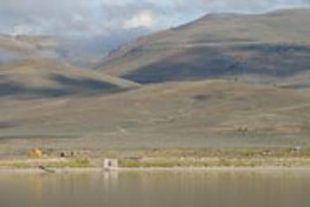
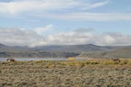
Stevens Creek Campground is on the north shore of the Blue Mesa Reservoir, the largest reservoir in Colorado and the most popular of the three in the Curecanti Recreation Area for boating, wind surfing and salmon fishing.

A bit downstream is the Morrow Point Reservoir and the Crystal Reservoir, both surrounded by the steep cliffs of the Black Canyon.

The Gunnison River carved the Black Canyon at a rate of one inch per every hundred years. Today, the canyon’s steepest cliff drops 2,250 feet at the Painted Wall.

Recreation

Jet skiing, water skiing, and canoeing are some of the many water activities available on the reservoir. Birding is also rewarding, with chances to see the black-billed magpie.

For hikers, try the 1.5-mile Neversink Trail, which meanders along a stream lined with wildflowers, cottonwoods and willows, located near a Great Blue Heron rookery.

Facilities

The 53-site campground offers waterfront-sites and a wide variety of amenities including a picnic area, self pay station and drinking water available late-May to mid-September.

Natural Features

The campground sits at an elevation of 7,540 feet and is characterized by a semi-arid, treeless shrubland. The mesa landscape is covered with sagebrush and receives less than 12 inches of rain a year.

Nearby Attractions

Head down to the Gunnison Diversion Tunnel, a National Historic Civil Engineering Landmark, or visit the Morrow Point Reservoir at the start of the Black Canyon. There, visitors can take a ranger-led pontoon boat through the upper Black Canyon. Find more tour information here.

Reservation

More from CampingHiking.net:

FISHHOOK PARK, Washington Campground Images, Info & Reservations

Directions From Pasco, Washington, take Highway 12 east. After crossing the Snake River Bridge, take the first exit and head east on State Route 124. Continue for 19 miles, then turn left, heading north on Fishhook Park Road. Follow for 4 miles to the park entrance; the campground is on

CEDAR CREEK (TN), Tennessee Campground Images, Info & Reservations

Directions From Nashville, TN. Travel East on I-40 to exit 221A. Continue onto TN-45/Old Hickory Blvd. Turn right onto US-70/Lebanon Pike. Turn left onto Nonaville Road and travel until reaching a 4-way stop. Turn right at the 4-way stop onto Saundersville Road. The recreation area will be at the end

COSBY PICNIC PAVILION, Tennessee Campground Images, Info & Reservations

Directions Seasonal phone is 423-487-2683 From Cosby, TN, proceed south on TN 32 about 1.5 miles from junction with US 321. Turn right at Cosby sign. Group camp is another 2.2 miles. Phone 423-487-2683 Activities HISTORIC & CULTURAL SITE, CAMPING, FISHING, HIKING, HORSEBACK RIDING, VISITOR CENTER, WILDLIFE VIEWING, DAY USE

POCKET PICNIC SHELTER, Georgia Campground Images, Info & Reservations

Directions From I-75, take Exit 320 (LaFayette/Resaca) and head west on Georgia State Route 136 for approximately 14 miles. Turn left onto Pocket Road and continue approximately 7 miles. The recreation area is on the left. The second driveway leads to the picnic shelter. Phone 706-695-6736 Activities HISTORIC & CULTURAL

WYETH CAMPGROUND, Oregon Campground Images, Info & Reservations

Directions From east or west on Oregon Interstate 84, take Wyeth exit #51. Turn west on Herman Creek Road. Wyeth Campground is 1/4 mile west of the interchange. Phone 541-308-1700 Activities BIKING, HIKING, BIRDING Keywords Related Link(s) Rec Area Info & Images Overview Wyeth Campground is just off of Interstate