GOOSEBERRY ADMIN SITE CABINS, UT Campground Reservation, Info, Images, Map, Directions

GOOSEBERRY ADMIN SITE CABINS, Utah Campground Images, Info & Reservations

Directions

From Salina, Utah, take I-70 eastbound about 7 miles to Gooseberry Road exit 63. Go south on County Road 640 for 10 miles to the Gooseberry Administrative Site on the right side of the road, just beyond Gooseberry Campground.

Phone

435-896-9233

Activities

CAMPING, FISHING, HORSEBACK RIDING, VISITOR CENTER, WILDLIFE VIEWING, DAY USE AREA

Keywords

GOSB,GOOSEBERRY RANGER STATION,GOOSEBERRY YCC CAMP,FISHLAKE NF – FS

Related Link(s)

Rec Area Info & Images

Utah State Road Conditions

Utah State Tourism

Overview

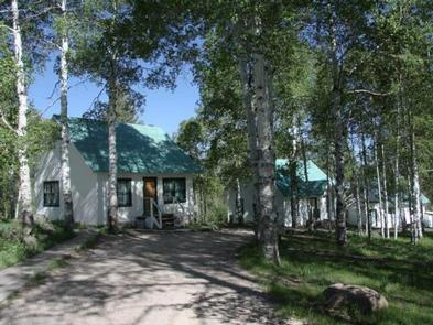
Gooseberry Administrative Site Cabins are located just 18 miles from Salina, Utah. These historic structures were used as Forest Service summer headquarters from 1907 to 1960. Today, the site is used for family reunions, group events, scout and church groups and youth camps.

Recreation

Popular activities in the area include off-road vehicle riding, fishing, hiking, biking, horseback riding and wildlife watching. The Great Western Trail runs nearby; two trailheads can be easily accessed near the site.

Facilities

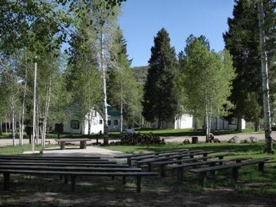
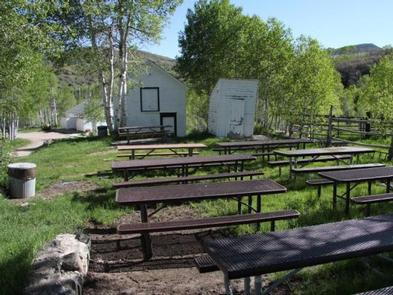
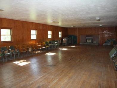
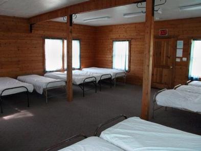
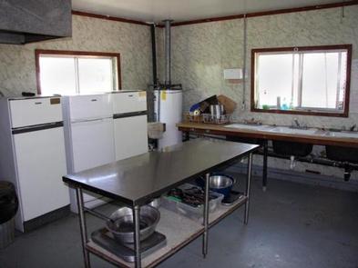
This unique facility contains three bunk cabins, one with propane heating, a recreation hall, kitchen and bathhouse. The rec hall has a fireplace, tables and chairs. The kitchen is equipped with a large propane cooking range and oven, three small propane refrigerators, three sinks, a prep and serving area, hot water and two outdoor grills. The bathhouse has flush toilets, sinks and hot showers.

Fifty single beds with mattresses are provided. Guests must bring their own linens or bedding, as well as dishes, utensils and cookware. A propane generator is available for electricity and lights for a couple of hours in the morning and evening. Several picnic tables and a campfire ring are located outside.

Guests are required to keep the facility clean during their stay. Maid service is not available. A volunteer host is on-site. Check-out time is by 11 a.m. and check-in time is after 2 p.m.

Natural Features

Gooseberry is situated in the Gooseberry drainage south of Interstate 70 in central Utah at an approximate elevation of 8,000 feet. Dense stands of aspens forest the area, offering shade and beautiful autumn color.

Reservation

More from CampingHiking.net:

COOK DAY USE AREA, Tennessee Campground Images, Info & Reservations

Directions From downtown Nashville, TN, take I-40 east for 7 miles to exit 221B. Turn right on Old Hickory Boulevard, left on Bell Road, right on New Hope Road and right on Stewarts Ferry Pike. Follow the signs to the picnic shelters. Phone 615-889-1975 Activities BOATING, HIKING, PICNICKING, WILDLIFE VIEWING,

MINERSVILLE CAMPGROUND, California Campground Images, Info & Reservations

Directions From Weaverville: take Highway 3 north for 15 miles. Turn right on Minersville/Bushtail Road for 1 mile. Phone 530-623-2121 Activities BOATING, CAMPING, FISHING, HIKING, WATER SPORTS, SWIMMING SITE Keywords Trinity Lake,Clair Engle Lake,Minersville Related Link(s) Rec Area Info & Images California State Road Conditions California State Tourism Forest Service

COGHILL LAKE CABIN, Alaska Campground Images, Info & Reservations

Directions The cabin is located on the southwest shore of Coghill Lake, on the lagoon just before Coghill River, on the east side of College Fiord in Prince William Sound. Accessible via float plane (50 minutes from Anchorage or 60 minutes from Cordova). The lagoon has enough water to taxi

STONY FORK CAMPGROUND, Virginia Campground Images, Info & Reservations

Directions From Wytheville, VA, follow I-77 north to Exit 47. Turn left onto Route 717 and drive 4 miles to Stony Fork Campground. Total travel distance is 10 miles. Phone 276-783-5196 Activities BIKING, CAMPING, FISHING, HUNTING, WILDLIFE VIEWING Keywords SFCA,GEORGE WASHINGTON/JEFFERSON NF-FS Related Link(s) Rec Area Info & Images Virginia

LAKES BASIN, California Campground Images, Info & Reservations

Directions In Graeagle, CA, at the intersection of State Rt. 89 and Forest Rt. 24 (Gold Lakes directional sign), turn onto Rt. 24 and go 6.9 miles to campground sign. Turn right onto the single-lane road and proceed 0.3 miles. The campground will be on the right. Phone CAMPGROUND/CAMPSITE STATUS

OUTLET AT PRIEST LAKE, Idaho Campground Images, Info & Reservations

Directions Physical Address: Priest River, ID 83856 From I-90; Turn at Post Falls Highway 41 north to Newport, WA. Take Highway 2 east to Priest River. At the junction of Highway 57 and Highway 2, turn left. Drive 26 miles to Outlet Bay Road. Turn right for approximately 0.5 mile.