Directions
The guard station is located about 26 miles north of Steamboat Springs, CO. From Steamboat Springs, take Highway 40 west and turn right on County Road 129. Head north on 129 (toward Clark) about 18 miles. One mile after Clark, take the first right after crossing the Elk River, Routt County Road 64, which is also Forest Service Road 400. Stay on this for 8 miles and the guard station is behind a locked gate, tucked in some trees on the left, across from the Seedhouse Campground. The last 3 miles is a dirt road and is not maintained in the winter.
Fall access to the guard station is over both paved and gravel/dirt roads. Road conditions are variable and 4-wheel drive vehicles are recommended.
Winter access to the guard station is by ski or snowmobile only. Parking is available at the end of county maintenance. The distance from a plowed road to the guard station is approximately 3.5 miles. The main road to the facility is a groomed snowmobile trail, but guests may have to break trail into the guard station.
Phone
970-870-2299
Activities
CAMPING, FISHING, HIKING, HORSEBACK RIDING, HUNTING, WINTER SPORTS, WILDLIFE VIEWING
Keywords
SEDH,MEDICINE BOW-ROUTT NF-FS
Related Link(s)
Colorado State Road Conditions
Overview
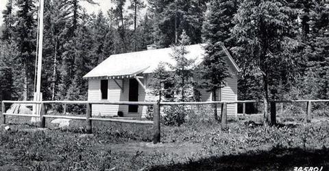
Seedhouse Guard Station is located approximately 26 miles north of Steamboat Springs, Colorado. It was constructed in 1933 and offers a unique lodging opportunity for guests seeking recreation and relaxation in the Routt National Forest.
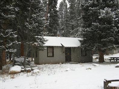
This historic cabin is available for rent in the fall and winter. Guests can drive directly to the cabin when the roads are clear; however, winter access is only available by snowmobiling, cross-country skiing or snowshoeing over three miles from the end of the plowed road. The cabin offers some amenities, but guests need to pack in several of their own supplies.
Recreation
Trailheads leading to hiking and horseback riding trails are an easy drive from the guard station. The Continental Divide National Scenic Trail passes near the cabin through the Mt. Zirkel Wilderness.
Anglers can fish for trout in the Elk River.
In winter, the area is blanketed by snow for wintertime play. Snowmobiling, skiing and snowshoeing are popular activities. All motorized activity, including snowmobiling, is prohibited in wilderness areas.
Facilities
The historic guard station is furnished with two sets of bunkbeds with mattresses and can accommodate up to four guests. Other amenities include a propane range, refrigerator, lights, heater, table and chairs, cooking utensils and cookware. A campfire ring and a picnic table are located outside. An outhouse with vault toilet is nearby. Horses may be kept in the corral or in the pasture; however, fencing is not provided. Hay must be certified weed-free. Drinking water and electricity are not available. Guests must provide their own supply of water for cooking, cleaning and washing. In winter, there is a large pot provided for melting snow. Guests need to provide their own food, lanterns or flashlights, sleeping bags, pillows, towels, dish soap, matches, first aid kit, toilet paper and garbage bags. All trash and food must be packed out, and guests are expected to clean the cabin before leaving.
Natural Features
The guard station is nestled beneath a canopy of fir and pine forest at an elevation of 8,000 feet along North Fork Elk Creek near the Middle Fork Elk River. Mount Zirkel Wilderness is nearby, one of the original areas protected under the 1964 Wilderness Act. The area boasts ecosystems ranging from sagebrush meadows in the lower areas to alpine tundra at high elevations.
Wildlife is abundant near the cabin, including elk, deer and coyote. Migratory birds, squirrels and an occasional black bear find habitat in the forest as well.


