

Directions
Indian Flats Cabin is located 40 miles northeast of Helena. Take Highway 280 east from Helena. Several miles after crossing the Missouri River, you will come to the small community of York. Turn left at the York Bar and proceed 5 miles to the smaller community of Nelson, where you should turn right. Stay on the main road up Beaver Creek, through a series of switchbacks up Burnt Gulch, past Pikes Gulch Campground to the junction of Hogback Lookout and Indian Flats Roads. Take the left hand fork for about 0.5 miles, and the cabin will be on the right.
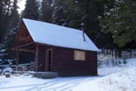
Access to the Indian Flats Cabin is dependent on the time of year and weather conditions. Usually during the summer and fall months, passenger cars can drive directly to the cabin. During the winter months, the cabin can only be accessed by snowmobiling or cross-country skiing approximately 8 miles.
Phone
406-449-5201
Activities
BIKING, HISTORIC & CULTURAL SITE, CAMPING, FISHING, HIKING, HORSEBACK RIDING, HUNTING, WINTER SPORTS, WILDLIFE VIEWING, FIRE LOOKOUTS/CABINS OVERNIGHT
Keywords
INDA,HOGBACK MOUNTAIN CABIN,HOGBACK LOOKOUT CABIN,INDIAN MEADOW CABIN,INDIAN MEADOWS CABIN,HELENA NF – FS
Related Link(s)
Overview
Indian Flats Cabin is nestled in a hollow of old-growth trees in the shadow of Hogback Mountain, offering a remote lodging experience in the Big Belt Mountains in west-central Montana.
The present Indian Flats Guard Station started its days as the Conway Station on Rock Creek in the Jim Ball Basin. The cabin was constructed in 1944 and replaced the original Conway Station. Rangers used this cabin when fulfilling duties in the area. In 1969, the cabin was relocated to its present location below Indian Flats.
During the summer and fall months, the cabin is typically accessible by car. During the winter months, poor road conditions and heavy amounts of snow can be present. Access to the cabin during snow conditions is via an 8-mile stretch of road passable by snowmobiling, snowshoeing or skiing. Guests should be prepared to pack in many of their own supplies.
Recreation
Plenty of opportunities are available for hiking, mountain biking and wildlife viewing near Indian Flats Cabin.
A hike through nearby Refrigerator Canyon passes through a 10-foot wide, 200-foot high canyon that was carved through limestone rock by a small mountain stream. The canyon is appropriately named, as breezes blowing over the stream and through the canyon’s rock walls cause evaporative cooling, creating temperatures 20 degrees cooler than surrounding areas.
An active fire lookout sits at the top of Hogback Mountain near the cabin. The Lookout is accessible by passenger vehicle and is manned by Forest Service personnel from mid-June through September. A short walk from the lookout offers spectacular panoramic views into Beaver Creek Canyon and surrounding landscapes.
Facilities
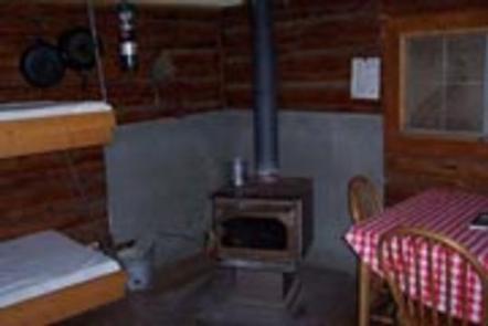
The single-room cabin is furnished with 2 sets of bunk beds with mattresses and accommodates up to 4 people. A wood stove provides heat for the cabin and a propane stove is available for cooking. The kitchen is equipped with a table and chairs, propane lantern, cleaning supplies, dishes, utensils and cookware.
An axe and snow shovel are provided. Firewood may be available, but it is not guaranteed. An outhouse with vault toilet is located nearby.
There is no electricity or water at this facility. Guests must bring a sufficient amount of water for drinking, cooking and washing, as well as 1 or 2 small propane cylinders to use for the lantern or stove.
Guests need to bring their own sleeping bags, flashlights, linens, towels, dish soap, matches, first aid kit, toilet paper and garbage bags. All trash and food must be packed out, and guests are expected to clean the cabin before leaving.
No firewood provided from June 1st – August 31
Natural Features
Indian Flats Cabin is backed by mixed conifer forest, and a small stream flows in front of it. Hogback Mountain is located within a mile of the cabin at an elevation of 7,813 feet.
The area around the cabin offers a variety of landscapes, from river banks to subalpine terrain. Valley bottoms, dense forests, meadows and barren ridges are mixed with streams, rivers and lakes.
Wildlife in the area abounds. Elk, deer, squirrels and a variety of birds are commonly seen. The more elusive badger, wolverine, mountain lion and lynx find habitat in nearby areas as well.
Nearby Attractions
The Gates of the Mountains Wilderness and the Missouri River are a short drive from the cabin, offering chances to explore.