BELOW DAM SOUTH CAROLINA, SC Campground Reservation, Info, Images, Map, Directions

BELOW DAM SOUTH CAROLINA, South Carolina Campground Images, Info & Reservations

Directions

The day use area is located just outside Clarks Hill, SC, west off US 221, just below the dam

Phone

800-533-3478

Activities

BOATING, FISHING, HIKING, PICNICKING, WILDLIFE VIEWING

Keywords

BDAM,J STROM THURMOND LAKE

Related Link(s)

Rec Area Info & Images

South Carolina State Tourism

South Carolina State Road Conditions

Overview

Below Dam South Carolina Recreation Area is a popular park just below J. Strom Thurmond Lake Dam along the Savannah River. The park is located on Power Plant Road just off South Carolina State Highway 221 near the Visitor Center. The Savannah River offers excellent fishing and boating opportunities.

Recreation

The 70,000 acre Thurmond Lake provides some of the best fishing, hunting, and water sports in the southeastern United States. Anglers fish for largemouth bass, bream, crappie, catfish and striped bass. The large lake offers endless boating, water skiing, jet skiing, canoeing and swimming opportunities.

Facilities

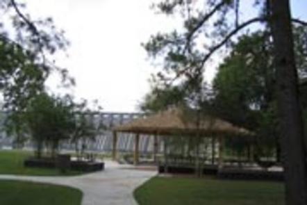
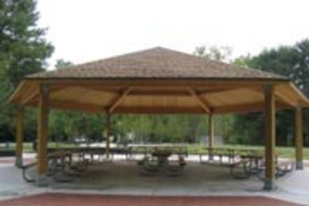
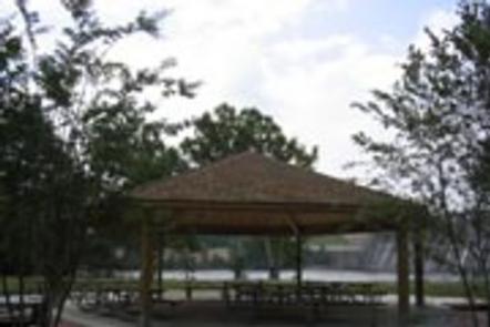
Below Dam South Carolina Recreation Area is a wooded day-use area with several group picnic shelters. One shelter has electrical hookups.

Other amenities include flush toilets, drinking water, a boat ramp, fishing pier, hiking trail and playground. There is no swimming at this park.

Natural Features

Hot, humid summers and mild, pleasant winters characterize this heavily wooded area on the shore of Thurmond Lake. A mixed pine and hardwood forest covers the site, providing summer shade and fall color. Elevation is 235′ above sea level.

Wildlife is abundant around the lake. Visitors regularly see southern bald eagles, osprey, migratory waterfowl, wild turkeys and whitetail deer.

Nearby Attractions

Numerous parks and recreation areas lie around Thurmond Lake, providing additional boating, swimming, hunting and hiking opportunities. Nearby cities house museums, art galleries, zoos, restaurants and shopping areas.

The Augusta National Golf Club hosts the Masters Golf Tournament annually the first week of April.

Reservation

More from CampingHiking.net:

BIG M, Missouri Campground Images, Info & Reservations

Directions From Cassville, Missouri, travel east on State Route 76 for 9 miles. Turn onto the Highway M access road and follow signs into the campground. Phone 417-271-3190 Activities BIKING, BOATING, CAMPING, FISHING, HIKING, PICNICKING, VISITOR CENTER, WATER SPORTS, WILDLIFE VIEWING, SWIMMING SITE, PHOTOGRAPHY, SWIMMING, RANGER STATION, KAYAKING, WATER ACCESS,

SPRINGHILL, Arkansas Campground Images, Info & Reservations

Directions From Barling, Arkansas, take SR-59 north for 1.5 miles and follow signs into campground. Phone 479-452-4598 Activities BIKING, BOATING, CAMPING, FISHING, HIKING, BIRDING Keywords SPRH,JOHN PAUL HAMMERSCHMIDT LAKE,JOHN PAUL HAMMERSC Related Link(s) Rec Area Info & Images Arkansas State Road Conditions Arkansas State Tourism Overview Springhill Park sits along

BLACK BUTTE CABIN, Montana Campground Images, Info & Reservations

Directions From Ennis, travel south on Highway 287 for about 32 miles to the West Fork Rest Area. Turn right onto West Fork Road/Forest Road 209 and continue for about 2 miles. Turn right onto Standard Creek Road/Forest Road 237 and travel 18 miles to the cabin. Maps may be

BIG BEND (WV), West Virginia Campground Images, Info & Reservations

Directions Follow 28/55 from Petersburg, West Virginia, for 8 miles. Turn left onto Smoke Hole Road, Route 28/11, and travel for 13 miles to County Route 2. Turn left onto the Smoke Hole Road, County Route 2, and follow for approximately 3 miles to Big Bend Campground. Phone 304-358-3253 Activities

PIEDMONT PARK, Missouri Campground Images, Info & Reservations

Directions From Piedmont, MO, follow Missouri State Highway HH. Travel on Highway HH for 6 miles to the top of the dam. Turn right and follow signs into campground. Phone 573-223-7777 (CLEARWATER LAKE PROJECT OFFICE) 573-223-4432 (PIEDMONT PARK GATE HOUSE) Activities BOATING, CAMPING, SWIMMING SITE Keywords PIED,CLEARWATER LAKE,PIEDMONT,PARK ABOVE THE

CATHEDRAL ROCK PICNIC AREA, Nevada Campground Images, Info & Reservations

Directions From Las Vegas, Nevada, take Highway 95 north to junction with Highway 157/Kyle Canyon. Turn left and travel approximately 21 miles to the picnic area at the end of the highway. Phone 702-872-5486 Activities CAMPING, HIKING, DAY USE AREA Keywords CATH,MOUNT CHARLESTON,LAS VEGAS,SPRING MTNS NAT. REC. AREA,HUMBOLDT-TOIYABE NF-FS Related