MILLPOND PAVILION, OR Campground Reservation, Info, Images, Map, Directions

MILLPOND PAVILION, Oregon Campground Images, Info & Reservations

Directions

From Roseburg, travel east on Highway 138 for 22 miles. Turn left (north) on Rock Creek Road and proceed 5 miles. Campground is on the right.

Phone

541-440-4930

Activities

BIKING, CAMPING, WATER SPORTS, FISH HATCHERY, SWIMMING SITE

Keywords

MIPA,Mill Pond Pavilion

Related Link(s)

Rec Area Info & Images

Oregon State Tourism

Oregon State Road Conditions

Overview

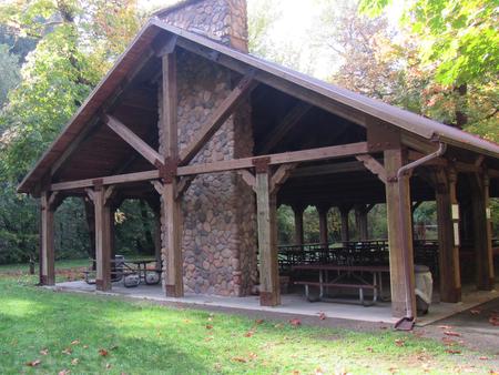
Millpond Pavilion is beautifully set along Rock Creek, which flows into the Wild and Scenic North Umpqua River. The pavilion boasts a large picnic shelter that holds up to 200 people with modern conveniences like drinking water, a sink, large grills, electrical outlets and a fireplace.

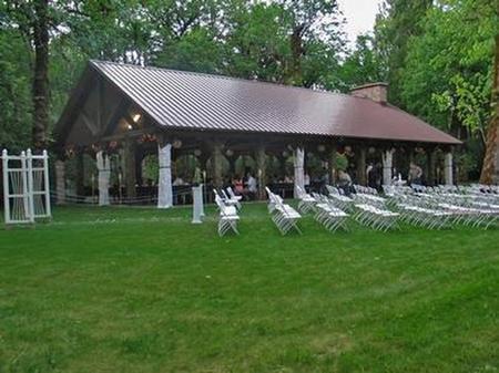
The flat grassy area is perfect for a casual game of soccer or a more special occasion, like an outdoor wedding.

In 1988 congress designated the North Umpqua River as a National Wild and Scenic River, preserving and protecting it for outdoor enthusiasts. The river is a tributary of the Umpqua River, which runs for over 200 miles from the Cascade Range of southwestern Oregon to the Pacific Ocean.

Recreation

Guests can play kickball, softball or other sports in the field that’s included in the pavilion reservation.

Adjacent to the pavilion are horseshoe pits and a playground to entertain young ones. From the pavilion, visitors can follow a 1-mile interpretive trail that passes through the site of an old lumber mill.

Facilities

Weddings and family reunions are very popular at this scenic destination. The long serving counter, stone fireplace, sink, two barbecue grills and multiple electric outlets create an ideal location for many festive occasions.

If groups choose to camp overnight, they can do so at the nearby first-come, first served Millpond Campground or the reservable Lone Pine Group Campground located across the road.

Natural Features

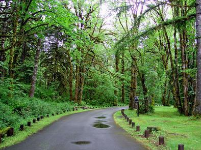
Millpond is just west of the Umpqua National Forest, in a lush region full of Douglas fir trees, western red cedar and sugar pines. The pavilion is in the foothills of the Cascade Mountains at an elevation of 1,170 feet.

Nearby Attractions

Visitors can get their adventure fix with kayaking and whitewater rafting and fishing in the North Umpqua River, just five miles away.

The incredibly scenic 79-mile North Umpqua Trail is ideal for mountain biking and hiking. And for a family-friendly destination, the nearby Rock Creek Fish Hatchery allows visitors to view salmon and steelhead.

Reservation

More from CampingHiking.net:

JEANETTE LAKE, Minnesota Campground Images, Info & Reservations

Directions From Orr, Minnesota, take St. Louis County Road 23 for 16 miles to Buyck. At Buyck, County Road 23 turns into County Road 24. Continue on County Road 24 for 8 miles to the Echo Trail. Turn right onto the Echo Trail and continue 12 miles to Jeannette Lake

HOOD CREEK CAMPGROUND, Montana Campground Images, Info & Reservations

Directions From Main Street in Bozeman, travel south on 19th Avenue for 7 miles, to the paved Hyalite Canyon Road. Turn left and continue 10 miles to the campground. Phone (406)646-1012 Activities BIKING, BOATING, CAMPING, FISHING, HIKING, PICNICKING, WILDLIFE VIEWING, DAY USE AREA, PHOTOGRAPHY, SWIMMING, MOUNTAIN BIKING, OFF ROAD VEHICLE

JACK CREEK CAMPGROUND, Oregon Campground Images, Info & Reservations

Directions From Sisters, OR: Travel 12.4 miles northwest on Highway 20, then 4.5 miles north on Forest Road 12, and then 0.6 miles north on Forest Road 1230. Phone 541-323-1746 Activities CAMPING Keywords Related Link(s) Rec Area Info & Images Oregon State Tourism Oregon State Road Conditions Overview Jack Creek

PARADISE IN OREGON, Oregon Campground Images, Info & Reservations

Directions From Eugene, Oregon, take I-105 east to McKenzie Highway 126 and drive 55 miles to McKenzie Bridge. The campground is located on the left side of Highway, 4 miles beyond McKenzie Bridge. Phone 801-226-3564 Activities BIKING, FISHING, HIKING, DAY USE AREA, WHITEWATER RAFTING Keywords PARO,PARADISE CAMPGROUND,WILLAMETTE NF -FS,PARADISE Related

CURTIS CREEK, Kansas Campground Images, Info & Reservations

Directions Take I-70 to the 290 exit and proceed north 5 miles to 837. Continue west on 837 for 6 miles to reach the park entrance. Phone 785-238-5714 Activities CAMPING Keywords CURC,MILFORD LAKE,MILFORD LAKE Related Link(s) Rec Area Info & Images Kansas State Tourism Kansas State Road Conditions Overview Curtis

MOUNTAIN OAK, California Campground Images, Info & Reservations

Directions From Wrightwood, CA, take State Rt. 2 west 2.4 miles to Palmdale/Jackson Lake sign (County Rt. N4/Pines Highway). Turn right onto Rt. N4 and go 3.1 miles to campground sign. Turn right into campground. Phone 760-249-3526 Activities BOATING, CAMPING, FISHING, HIKING, WILDLIFE VIEWING, SWIMMING SITE, CANOEING, BIRDING, SCENIC DRIVE