VAN PUGH SOUTH CAMPGROUND, GA Campground Reservation, Info, Images, Map, Directions

VAN PUGH SOUTH CAMPGROUND, Georgia Campground Images, Info & Reservations

Listen

Directions

Take I-85 north to I-985, take Exit 8, turn left on Highway 347/Friendship Road. Turn right on McEver Road, then left on Gaines Ferry Road and follow signs to the campground.

Phone

770-967-6315

Activities

BOATING, CAMPING, FISHING, PICNICKING, WATER ACTIVITIES, WATER ACCESS

Keywords

VAN PUGH SOUTH CAMPGROUND (GA),Van Pugh South Campground,LAKE LANIER,LAKE SIDNEY LANIER

Related Link(s)

Rec Area Info & Images

Georgia State Tourism

Georgia State Road Conditions

Overview

Van Pugh South Campground lies on the banks of Lake Sidney Lanier in the foothills of the Blue Ridge Mountains of Northern Georgia. The popular lake boasts nearly 700 miles of shoreline and over 100 small islands, providing over 11 million annual visitors with limitless recreation opportunities.

Recreation

Lake Lanier offers excellent boating, fishing and swimming. The lake offers additional opportunities for kayaking, wake boarding and much more.

Facilities

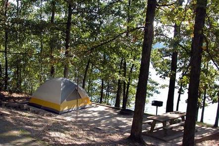
The campground contains 37 sites with water and electric hookups and 18 primitive tent-only sites. Amenities include accessible flush toilets and showers, drinking water, laundry facilities and a dump station. An accessible boat ramp is on-site.

Natural Features

The reservoir was created in 1956 with the completion of Buford Dam on the Chattahoochee River, and today spans 38,000 acres of water in the lush foothills of the Blue Ridge Mountains. Dense forests of oak, hickory and pine cover the region, providing shade in the campground and abundant wildlife habitat.

Nearby Attractions

Lake Lanier Islands is within driving distance and along with other parks provides many opportunities for outdoor recreation. There are several towns within driving distance that provide opportinuties to explore.

Charges & Cancellations

Cancellations must be made via the online/phone reservation system or in person at the gatehouse. Cancellation calls to the gatehouse will not be honored.

Reservation

More from CampingHiking.net:

Denny Creek Campground, Washington Campground Images, Info & Reservations

Listen Directions From Seattle, take Interstate 90 east to exit 47. Go north over the freeway and follow signs 3 miles to campground. Phone 360-804-1103 Activities CAMPING, FISHING, HIKING Keywords DENN,MT. BAKER-SNOQU NF – FS Related Link(s) Rec Area Info & Images Washington State Road Conditions Washington State Tourism Forest

GRANITE FLAT (UTAH), Utah Campground Images, Info & Reservations

Listen Directions From Salt Lake City, Utah, take I-15 to the Alpine-Highland exit 284. Go east on Highway 92 for 8 miles to mouth of American Fork Canyon. Go 5 miles up the canyon to junction, take the North Fork/Forest Road 85 to Tibble Fork Reservoir. Stay left on paved

BANDY CREEK, Tennessee Campground Images, Info & Reservations

Listen Directions For detailed directions, please visit: http://www.nps.gov/biso/planyourvisit/directions.htm Phone (423) 286-7275 Activities BIKING, CAMPING, INTERPRETIVE PROGRAMS, FISHING, HIKING, HORSEBACK RIDING, HUNTING, PICNICKING, VISITOR CENTER, WILDLIFE VIEWING, DAY USE AREA, PHOTOGRAPHY, SWIMMING, MOUNTAIN BIKING, KAYAKING, STAR GAZING, BIRDING, NON-MOTORIZED BOATING, EVENING PROGRAMS, RAFTING, BACKPACKING, AMPHITHEATER, ACCESSIBLE SWIMMING Keywords CG02,BANDY,BIG SOUTH FORK

ISLET CAMPGROUND, Oregon Campground Images, Info & Reservations

Listen Directions Located 37.3 miles east of Oakridge, Oregon. From Oakridge, Oregon: At the intersection of Crestview Street and Oregon State Highway 58, travel east on Highway 58 for 23.3 miles. Turn left on the Waldo Lake Road/Forest Road 5897. Travel for 12.8 miles and turn left at the T

CLEAR LAKE GROUP SITE, Washington Campground Images, Info & Reservations

Listen Directions From Naches, Washington, follow Highway 12 west for approximately 34 miles to County Road 1200/Tieton Reservoir Road at the west end of Rimrock Lake. Turn south/left on County Road 1200 and follow for about .3 miles to Road 740. Continue for a half-mile, and the reservation site is