BUTTERCUP GROUP CAMP, CA Campground Reservation, Info, Images, Map, Directions

BUTTERCUP GROUP CAMP, California Campground Images, Info & Reservations

Directions

From San Bernardino, take I-10 east to Running Springs. Turn onto State Highway 18 and continue to Big Bear Lake Dam. Continue about 6 miles on State Highway 18 and turn right on Summit Boulevard. Turn left at the end of road and go about a half-mile to the second gate on the right.

Phone

909-866-8550

Activities

BOATING, CAMPING, FISHING, HIKING, WATER SPORTS, SWIMMING SITE

Keywords

BUTT,SAN BERNARDINO NF – FS

Related Link(s)

Rec Area Info & Images

California State Tourism

Forest Service Concessionaire

California State Road Conditions

Overview

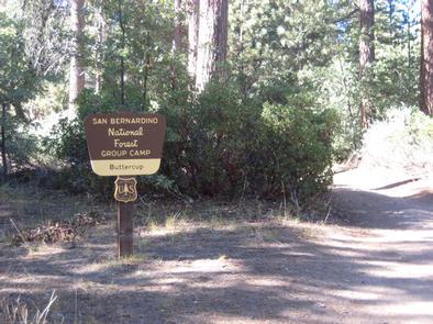
Buttercup Group Camp is an outdoor oasis nestled in Southern California’s pine-covered mountains. Big Bear Lake is nearby, a popular destination for a variety of recreational activities. The campground offers a great escape from city life and it is one of the best locales for group camping.

Recreation

Fishing and boating at Big Bear Lake are popular activities. Anglers can look forward to trout, bluegill, crappie, catfish and largemouth bass, among other species. Because of the very cold water and the presence of underwater obstacles near the shoreline, swimming at the lake is sometimes discouraged.

Visitors also enjoy the area’s plentiful hiking, mountain biking and climbing opportunities. The campground provides access to a number of trails and points of exploration.

Facilities

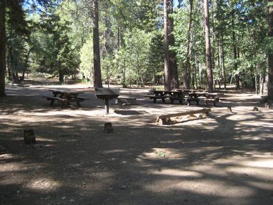
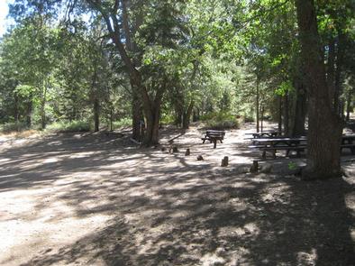
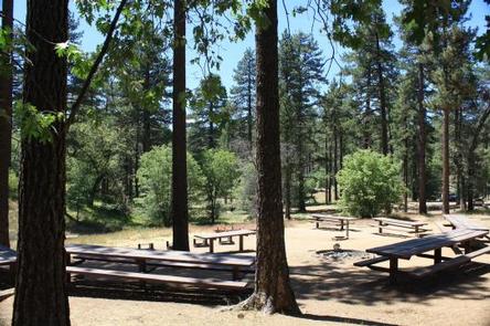
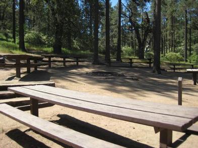
The group campground offers one large, accessible site that can accommodate up to 40 people and eight vehicles for tent or RV camping. The site is equipped with tables, grills and a campfire circle. Vault toilets and drinking water are provided.

Natural Features

The group campground is situated at an elevation of about 7,000 feet and is heavily forested with pine trees. The site is relatively shady and secluded. It is about two miles from Big Bear Lake and is accessed by a dirt road.

Nearby Attractions

A general store and restaurants can be found in the city of Big Bear Lake.

Reservation

More from CampingHiking.net:

ARCH DAM CAMPGROUND, Utah Campground Images, Info & Reservations

Directions From Vernal, Utah, take U.S. 191 north for about 46 miles. From Manila, Utah, take Highway 44 for 28 miles. Turn left on U.S. 191 and go about 6 miles north. From Rock Springs, Wyoming, take I-80 west toward Green River about 6 miles to the junction with U.S.

SOUTH SANDUSKY CAMPGROUND, Illinois Campground Images, Info & Reservations

Directions From I-57 take exit 71 and turn west onto Route 14. After 3 miles turn right on Rend City Road, then continue for 6 miles to the campground entrance on the right. Phone 618-724-2493 Activities BIKING, CAMPING, INTERPRETIVE PROGRAMS, FISHING, HIKING, WILDLIFE VIEWING, SWIMMING SITE, STAR GAZING Keywords SSAN,REND

SWINGING BRIDGE, Idaho Campground Images, Info & Reservations

Directions From Horseshoe Bend, ID, take State Rt. 55 north for 21.5 miles to the campground sign. Turn left after the sign into the campground(on west side of highway). Phone 541-351-1182 Activities BOATING, CAMPING, FISHING Keywords SWIN,PAYETTE RIVER HIGHWAY 55,BOISE NF – FS Related Link(s) Rec Area Info & Images

CANEBRAKE HORSE CAMP, North Carolina Campground Images, Info & Reservations

Directions The address is 616 McLeans Creek Road, Troy, NC 27371. From Troy, North Carolina, take State Highway 109 north for approximately 10 miles. Turn left onto Mullinix Road (State Highway 1154) and travel approximately 1.5 miles to a stop sign and “T” intersection. Turn right, and travel about 0.25

HOUSTON SHELTER, Alabama Campground Images, Info & Reservations

Directions About 50 miles southwest of Decatur, take Highway 278 east from Double Springs for 8 miles. Turn south on County Road 63 and continue for 4 miles. Turn right onto Forest Service Road 118 and travel a mile to the campground. Phone 205-489-5111 Activities BOATING, FISHING, HIKING, WILDERNESS, DAY