ALPINE VIEW CAMPGROUND, CA Campground Reservation, Info, Images, Map, Directions

ALPINE VIEW CAMPGROUND, California Campground Images, Info & Reservations

Directions

From Weaverville: take Highway 3 north for 22.5 miles. Turn right on Guy Covington Road for 2.4 miles to the campground.

Phone

530-275-8113

Activities

CAMPING, FISHING, HIKING, WATER SPORTS

Keywords

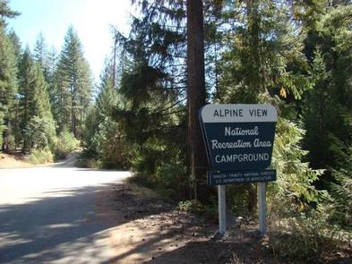
Trinity Lake,Alpine View

Related Link(s)

Rec Area Info & Images

California State Road Conditions

Forest Service Concessionaire

California State Tourism

Overview

Alpine View Campground is located in the Trinity Unit of the Whiskeytown-Shasta-Trinity National Recreation Area at an elevation of 2,400 feet. This facility is a great choice for children, the elderly and those with accessibility needs who require well-developed trails and campsites. Visitors enjoy a variety of recreational activities in a beautiful setting.

Recreation

The area offers excellent opportunities for fishing, boating and hiking around Trinity Lake. The campground is very popular with the boating public, as the Bowerman boat ramp is located a quarter-mile before the campground entrance.

Anglers can fish for catfish, as well as different varieties of trout, salmon and bass. Hikers can access several trails in the area, including the 0.3-mile Lake Trail.

Facilities

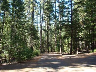
This is a 53-unit family campground that offers several accessible campsites and three accessible restrooms with flush toilets. The campground features paved social areas, roads and spurs. The maximum vehicle length is 32 feet.

Each campsite is furnished with a picnic table and campfire ring. Some of the campsites have bear-proof food storage lockers. Drinking water is provided.

Natural Features

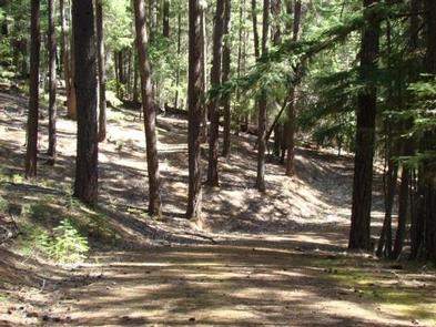
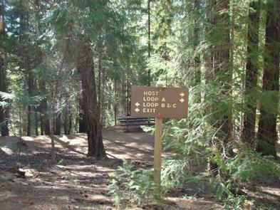
This scenic campground has three loops (A, B and C) with sites that wind through a grove of Douglas fir and cedar with an understory of ferns. Some sites in Loops A and B have a view of Trinity Lake.

Bears frequent the area, but a wide variety of wildlife may be seen in and around Trinity Lake.

Reservation

More from CampingHiking.net:

KIRBY COVE CAMPGROUND, California Campground Images, Info & Reservations

Directions From San Francisco (travelling north):  Cross the Golden Gate Bridge and take exit 442 onto Alexander Avenue. This will be the exit after the Vista Point. Continue straight for about a mile, and then turn left onto Bunker Road. Travel through the Baker-Barry Tunnel and continue straight until you

Pioneer Ford Campground, Oregon Campground Images, Info & Reservations

Directions From Sisters, OR: Travel 9.6 miles northwest on Highway 20, then 12.6 miles north on Forest Road 14. Phone 541-323-1746 Activities CAMPING Keywords Related Link(s) Rec Area Info & Images Oregon State Road Conditions Oregon State Tourism Overview Pioneer Ford is one of the most popular of the campgrounds

ALPINE RANGER STATION, Colorado Campground Images, Info & Reservations

Directions From Gunnison: Take US-50 west for approximately 35 miles. Turn left on Co. Rd 66 to FSR 867. Follow FSR 867 for approximately 20 miles to its junction with FSR 868. Turn right – Alpine Ranger Station will be 5 miles ahead on the right-hand side. Phone 970-641-0471 Activities

PRINCESS CREEK CAMPGROUND, Oregon Campground Images, Info & Reservations

Directions From Crescent, OR: Travel 12.2 miles west on County Road 61/Crescent Cut-off Road, then 9.1 miles northwest on Highway 58. Phone 541-323-1746 Activities CAMPING Keywords PRINCESS CREEK CAMPGROUND Related Link(s) Rec Area Info & Images Oregon State Road Conditions Oregon State Tourism Overview Located next to Odell Lake, Princess

PAULSON BAY CABIN, Alaska Campground Images, Info & Reservations

Directions To access the cabin by float plane: it is 40 minutes from Anchorage and 60 minutes from Cordova. By boat, the trip is 18 miles from Whittier. Note: the Bay is not obvious because the mouth is partially obscured by five small islands. Beware of submerged rock ledges between