

Directions
From Blue River, OR, travel 4 miles east on Highway 126 to Aufderheide Drive/Forest Service Road (FSR) 19. Continue south on Aufderheide Drive, taking a right at the Y and climbing to the top of Cougar Reservoir. Continue south on Aufderheide Drive past Cougar Reservoir 7 miles to FSR 1980. Turn west on FSR 1980 and climb up Indian Ridge to
Phone
541-822-3381
Activities
CAMPING, WILDLIFE VIEWING, BERRY PICKING, STAR GAZING, BIRDING
Keywords
INRL,WILLAMETTE NF -FS
Related Link(s)
Overview
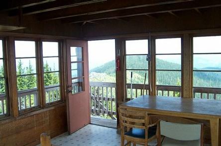
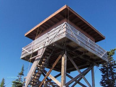
The Indian Ridge Lookout sits at an elevation of 5,405 feet in the Willamette National Forest. Built in 1958, the lookout was used for firefighting by Forest Service personnel until 1973. The lookout is still staffed occasionally during emergencies. The lookout is accessible by car, although the access road is rocky. Guests must be prepared to climb steep, narrow steps up the 30-foot tower to access the lookout’s cabin. The accommodations are primitive, so guests should be prepared to pack in most of their own supplies and gear.
Recreation
From the lookout’s perch above the tree line and far away from city lights, guests can enjoy spectacular night skies and star gazing. An unmaintained trail on the ridge meanders through alpine trees and beargrass, allowing hikers to explore the mountaintop. The French Pete Trail Area in the Three Sisters Wilderness offers several miles of hiking. Cougar Reservoir and Hidden Lake are also in the vicinity, offering additional recreation options.
Facilities
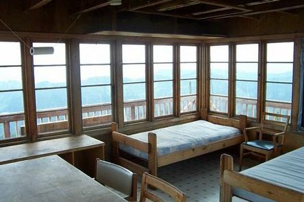
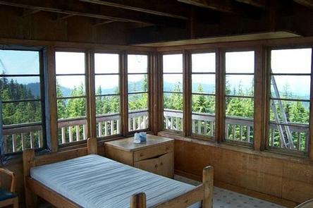
The 16×16-ft. cabin sleeps 4 and is equipped with 2 twin beds with foam mattresses, a table with chairs, broom and dust pan, mop and storage shelves. An outhouse with vault toilet is located 50 feet from the lookout and a picnic table and fire ring are outside. No heat, electricity or water are available. Guests must bring their own water for drinking, cooking and washing. Propane cook stoves and lanterns are recommended, since they create fewer fumes than liquid gas appliances. Items such as a cook stove, bedding, flashlights, dishes and cookware, matches, extra toilet paper, first aid supplies, trash bags, dish soap, towels and an ice chest are not available. Guests are expected to pack out their trash and clean the cabin before leaving.
Natural Features
Views from the lookout include the Three Sisters, which are close and prominent to the northeast, along with views of the Cascade Crest both north and south. The Sand Mountain and Carpenter Mountain Lookouts are visible with binoculars. Hidden Lake is visible below the northern edge of mountaintop. The open ridge is covered with beargrass and huckleberries. Several rocky outcroppings are covered by wildflowers and mossy vegetation, depending on the season. Willamette National Forest offers prime habitat for such species as Roosevelt elk, black bear, bald eagles, black tail deer and bobcats, among other wildlife.
Nearby Attractions
A short trail to Hidden Lake offers access to alpine swimming and sunbathing.