JENNINGS FERRY, AL Campground Reservation, Info, Images, Map, Directions

JENNINGS FERRY, Alabama Campground Images, Info & Reservations

Directions

From Demopolis, Alabama, take Highway 43 north towards Eutaw. At Highway 14, take a right. Proceed for approximately seven miles to the park.

Phone

205-372-1217

Activities

CAMPING, FISHING, HIKING

Keywords

JENF,BLACK WARRIOR

Related Link(s)

Rec Area Info & Images

Alabama State Tourism

Alabama State Road Conditions

Overview

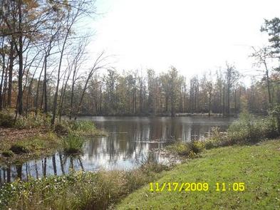
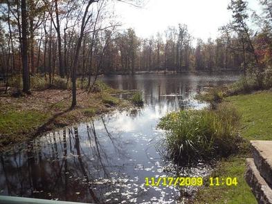
Jennings Ferry Campground is situated between the Black Warrior River and Clear Creek on the Black Warrior-Tombigbee Waterway in Alabama. With a boat ramp and gently sloping shoreline, this facility offers a quiet and convenient getaway for fishing.

Recreation

Fishing is the most popular activity on the waterway. Whether fishing by boat or along the shore of the park, anglers can fish for bass, crappie, bream, catfish and other species.

Visitors can also enjoy walking along a half-mile nature trail that runs through the woods following the water’s edge.

Facilities

Jennings Ferry has 52 campsites with 50-amp electrical and water hookups and picnic areas.

Campsites are spacious, private and located near or close to the water. A shower and restroom building, as well as coin-operated laundry facilities, a playground and boat ramp with security lighting are also provided for camper convenience.

Natural Features

The campground is surrounded by the scenic woodlands of the Tombigbee River. Deer, squirrel, wild turkey, migratory birds and blue birds live among the calm waters and hardwood forests of the area.

Temerature range from the 80s to 90s from April to September, and annual rainfall averages about 60 inches. The facility is located 100 feet above sea level.

Reservation

More from CampingHiking.net:

MOUNT FLEMER CABIN, Alaska Campground Images, Info & Reservations

Directions The cabin is located on the south shore of the Stikine River within the Stikine-LeConte Wilderness. It is two miles downriver from the border between the United States and Canada. Distance from Wrangell is 32 miles by shallow draft boat. Low river levels can affect access; consult local tide

DRAKE PEAK LOOKOUT, Oregon Campground Images, Info & Reservations

Directions From the Lakeview Ranger District Office, travel 6 miles north on Highway 395, and turn right on Highway 140. Take Highway 140 east for 8 miles, then turn left on Forest Road 3615. Continue on Forest Road 3615 for 7.5 miles and turn right on Forest Road 019. Follow

Anthony Lake, Oregon Campground Images, Info & Reservations

Directions From Baker City, head north on Highway 30 toward Haines, approximately 10 miles. In Haines, turn left and follow the Anthony Lake Highway signs (turns into Forest Road 73) for 25 miles to the Anthony Lake Recreation Area. Turn left into the Anthony Lake Campground. The main campground is

FISH CREEK PAVILION, Idaho Campground Images, Info & Reservations

Directions From Grangeville, head south on Grangeville-Salmon Road for approximately 7 miles to the Fish Creek Meadows area. Turn right onto Forest Road 4600. The entrance to Fish Creek Pavilion is located 300 feet ahead on the left. Phone 208-983-1950 Activities CAMPING, HIKING, HORSEBACK RIDING Keywords None Related Link(s) Rec

SANDSTONE CABIN, Wyoming Campground Images, Info & Reservations

Directions From Encampment, Wyoming, travel west on State Highway 70, approximately 26 miles to the Sandstone Work Center. Turn right into Work Center compound and the Sandstone Cabin will be located on your left. From Baggs, Wyoming, travel east on State Highway 70, approximately 32 miles to the Sandstone Work

JUDITH GUARD STATION, Montana Campground Images, Info & Reservations

Directions From Great Falls, travel east on U.S. Highway 87 for about 63 miles to Windham, Montana, from Windham turn right off HWY 200/87 and head south for approximately 10 miles until the town of Utica. Turn right at Utica, continue south for approximately 13 miles on the county road.