CARTER MEADOWS HORSE GROUP, CA Campground Reservation, Info, Images, Map, Directions

CARTER MEADOWS HORSE GROUP, California Campground Images, Info & Reservations

Directions

From Interstate 5 near Yreka, California, take the south Yreka exit onto Highway 3 south and continue for 23 miles. Turn right on Highway 93 toward Cecilville and continue 12 miles to Carter Meadows Summit. Approximately 1/2 mile beyond the summit, turn left on Road 39N08. The Group Site is another 1/4 mile on the right.

Phone

530-468-5351

Activities

CAMPING, FISHING, HIKING, HORSEBACK RIDING

Keywords

CARH,CARTER,CARTER MEADOWS,CARTER MEADOWS HORSE,MEADOWS HORSE GROUP,MEADOWS GROUP,CARTER HORSE,CARTER GROUP,MEADOWS HORSE,HORSE,MEADOWS,KLAMATH NF – FS

Related Link(s)

Rec Area Info & Images

California State Tourism

California State Road Conditions

Overview

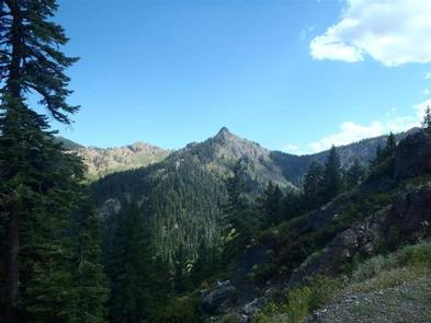
The Carter Meadows Horse Group Campground lies at the southern edge of the Klamath National Forest on the South Fork of the Salmon River. Designed for large groups with horses, the camp’s proximity to the Trinity Alps Wilderness and the Pacific Crest Trail makes the site popular with riders and hikers.

Recreation

The Carter Meadows Horse Group Site is adjacent to the Trinity Alps Wilderness and the Pacific Crest Trail. From this site, groups can ride to three trailheads that access several wilderness lakes and many miles of trails.

Fishing is available in nearby streams and wilderness lakes.

Facilities

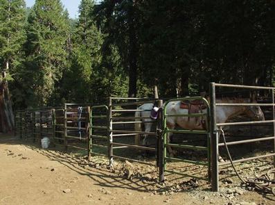
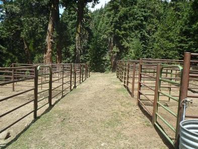
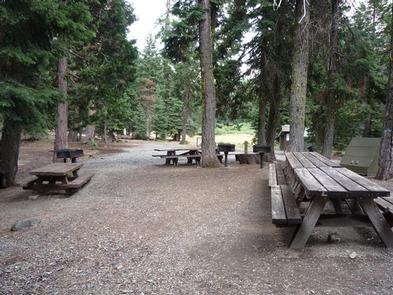
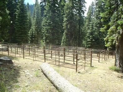
The Carter Meadows Horse Group Site is designed for up to 25 people and 25 horses. It includes an area for dispersed tent or trailer camping and three sections of corrals of varying sizes: seven one-horse corrals, three 2-horse corrals and three 3-4 horse corrals.

The site also includes a gravel parking area, a gated entrance, a hitch rack and a mounting ramp.

Natural Features

The Klamath National Forest encompasses nearly 2 million acres of land straddling the California and Oregon border.

The Klamath is a vast array of mountains, streams and lakes and, at elevations ranging from 450 to 8,900 feet, is home to diverse plant life and nearly 400 animal species. The partially shaded campground sits at an altitude of 5,800 feet.

Nearby Attractions

A short drive away, the Carter Meadows Summit is accessible for day hikes along the Pacific Crest Trail to Hidden and South Fork Lakes.

Reservation

More from CampingHiking.net:

LIMBERLOST CAMPGROUND, Oregon Campground Images, Info & Reservations

Directions From McKenzie Bridge, travel east on Hwy 126 to Hwy 242. Follow Hwy 242 approximately 2 miles east to Limberlost Campground. Phone 801-226-3564 Activities BIKING, BOATING, HIKING Keywords Limberlost Campground Related Link(s) Rec Area Info & Images Forest Service Concessionaire Oregon State Road Conditions Oregon State Tourism Overview This

KALALOCH, Washington Campground Images, Info & Reservations

Directions Kalaloch Campground is on Highway 101, 34 miles south of Forks, Washington, and 73 miles north of Aberdeen, Washington. Phone 360-565-3130 Activities CAMPING, HIKING, VISITOR CENTER, WILDLIFE VIEWING Keywords Clay-lock,Clay Lock,Olympic National Park Related Link(s) Rec Area Info & Images Washington State Tourism Washington State Road Conditions Overview Kalaloch

Panther Creek campground, Washington Campground Images, Info & Reservations

Directions From Carson, WA: Travel 6 miles north to Old State Highway, (follow signs) turn right and then take your first left on Panther Creek Road. Proceed on Panther Creek Road for 4 miles to the campground. Phone 541-338-7869 Activities CAMPING, FISHING, HIKING, HUNTING Keywords PANC,GIFFORD PINCHOT NF – FS

RED CANYON, Utah Campground Images, Info & Reservations

Directions Located on Forest Road 095/Red Canyon Road off Highway 44, approximately 40 miles north of Vernal, Utah. Phone 435-784-3445 Activities BIKING, BOATING, CAMPING, FISHING, HIKING, WILDLIFE VIEWING Keywords RECA,RED CANYON COMPLEX,FLAMING GORGE,ASHLEY NF – FS,Flaming Gorge National Recreation Area Related Link(s) Rec Area Info & Images Utah State Tourism

JOPLIN, Arkansas Campground Images, Info & Reservations

Directions From Hot Springs, Arkansas: Take US 270 west for 23.5 miles to Mountain Harbor Road. Turn right and follow access road three miles north to the park. Phone 870-867-4472 Activities BIKING, BOATING, CAMPING, FISHING, WATER ACTIVITIES, KAYAKING, CANOEING Keywords JOPL,LAKE OUACHITA,MOUNTAIN HARBOR,LAKE OUACHITA Related Link(s) Rec Area Info &