
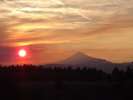
The spectacular Deschutes National Forest in Deschutes County has many beautiful camping areas to choose from. This page covers 56 of them, complete with images, maps, directions, and more.
Visitors can enjoy campsites featuring a wide-variety of picturesque backdrops. Camping opportunities range from rustic, walk-in sites to sites accommodating full-size RV’s and trailers.
Click through on the images below for full details of what each Deschutes camping area has to offer. When you find one you like, you can reserve a site from there.
WHITEFISH HORSE CAMP, Oregon Campground Images, Info & Reservations
Listen Directions From I-5, take exit 188A towards Oakridge, continue on Hwy 58 for 69.3 miles, then turn right at NF Road 60 and continue for 2.2 miles. Turn right at Crescent Lake Road and continue for 1.2 miles. Make a slight right at NF Road 60 and travel for 3.5 miles to your destination on the left. From La Pine, travel south on Hwy 97 for 17.5 miles, then turn right at the Crescent Cutoff Road, continuing for 11.9 miles. Turn right at Hwy 58 and travel
Simax Group Camp, Oregon Campground Images, Info & Reservations
Listen Directions From Highway 58, turn south at Crescent Lake Junction on Forest Service Road 60. Travel 2.2 miles to the junction with Forest Service Road 6005. Continue a mile south, following signs. Phone 541-323-1746 Activities CAMPING Keywords SIMA,DESCHUTES NF – FS Related Link(s) Rec Area Info & Images Oregon State Road Conditions Oregon State Tourism Forest Service Concessionaire Overview Simax Group Campground is located on the northeast end of Crescent Lake in Deschutes National Forest, offering visitors some of the most beautiful scenery in central Oregon and
BLUE BAY, Oregon Campground Images, Info & Reservations
Listen Directions From Sisters, travel approximately 13 miles northwest on Highway 20/126. Turn left onto Forest Road 2070 (Suttle Lake Campgrounds). Travel just less than 1/2-mile to Blue Bay entrance on the right. Phone 541-323-1746 Activities BOATING, CAMPING, INTERPRETIVE PROGRAMS, FISHING, HIKING Keywords BLBA,SUTTLE LAKE CAMPGROUND,DESCHUTES NF – FS Related Link(s) Rec Area Info & Images Oregon State Tourism Oregon State Road Conditions Forest Service Concessionaire Overview Blue Bay Campground is situated in a diverse forest of pine and fir on the south shore of Suttle Lake in
LINK CREEK, Oregon Campground Images, Info & Reservations
Listen Directions Travel approximately 13 miles northwest of Sisters on Highway 20/126. Turn left onto Forest Road 2070/Suttle Lake Campgrounds. Travel less than 1/2 mile to Blue Bay entrance on the right to Link Creek. Phone 541-323-1746 Activities BOATING, CAMPING, FISHING Keywords LINK,SUTTLE LAKE CAMPGROUND,DESCHUTES NF – FS Related Link(s) Rec Area Info & Images Oregon State Road Conditions Forest Service Concessionaire Oregon State Tourism Overview Link Creek Campground is situated on the shores of Suttle Lake in the Deschutes National Forest. Visitors enjoy boating, fishing, hiking and
Scout Lake, Oregon Campground Images, Info & Reservations
Listen Directions From Sisters, Oregon, take Highway 20/126 NW for 12 miles. Turn left onto Forest Service Road 2070. Travel just less than a mile and turn left again onto Forest Service Road 2066 and continue to the campground entrance on the right. Phone 541-323-1746 Activities CAMPING, FISHING Keywords SCOU,DESCHUTES NF – FS Related Link(s) Rec Area Info & Images Oregon State Tourism Forest Service Concessionaire Oregon State Road Conditions Overview Scout Lake Group Campground sits near the shores of its namesake in Deschutes National Forest. Its proximity
South Shore, Oregon Campground Images, Info & Reservations
Listen Directions From Sisters, Oregon, take Highway 20/126 northwest for about 12 miles. Turn left onto Forest Service Road 2070 toward Suttle Lake Campgrounds. Travel just less than a half-mile to the South Shore entrance on the right. Phone 541-323-1746 Activities BOATING, CAMPING, FISHING, HIKING, SWIMMING SITE Keywords SOUH,SUTTLE LAKE CAMPGROUND,DESCHUTES NF – FS Related Link(s) Rec Area Info & Images Oregon State Tourism Oregon State Road Conditions Forest Service Concessionaire Overview South Shore Campground is located along Suttle Lake, shaded by Douglas fir and Ponderosa pine. One
OGDEN GROUP, Oregon Campground Images, Info & Reservations
Listen Directions From Bend, drive south on Highway 97 for 22 miles. Head east on Road 21 for 3 miles. Ogden Group is on the left. Phone 541-383-5300 Activities CAMPING Keywords OGDE,DESCHUTES NF – FS Related Link(s) Rec Area Info & Images Forest Service Concessionaire Oregon State Tourism Oregon State Road Conditions Overview Ogden Group campground is located in the high desert region of central Oregon, on the scenic Paulina Creek. The campground is surrounded by scenery that sets the stage for fantastic recreational opportunities in Deschutes National
WINDY GROUP CAMP, Oregon Campground Images, Info & Reservations
Listen Directions Take Highway 58 approximately 8 miles east of Willamette Pass to the Crescent Lake Junction. Turn west on Forest Road 60 and continue approximately 7 miles to the campground. Phone 541-323-1746 Activities BOATING, CAMPING, FISHING, HIKING, SWIMMING SITE Keywords WING,DESCHUTES NF – FS Related Link(s) Rec Area Info & Images Oregon State Road Conditions Oregon State Tourism Forest Service Concessionaire Overview Located on the southwest end of spectacular Crescent Lake in Deschutes National Forest, Windy Group Campground offers visitors the opportunity to experience the beauty and
Cinder Hill Campground, Oregon Campground Images, Info & Reservations
Listen Directions From Bend, travel 23 miles south on Highway 97 to Forest Road 21. Turn onto Forest Road 21 and go about 17 miles east. Take Forest Road 300 north for 0.5 miles. From La Pine, go 5 miles north on Highway 97 to Forest Road 21. Take Forest Road 21 east about 17 miles. Take Forest Road 300 north for 0.5 miles. Phone 541-383-5300 Activities BIKING, BOATING, CAMPING, FISHING, HIKING Keywords CINH,Cinderhill,Cind,Cinder,Cinder Hill,Cinder Hill Campground,Cinder Hill Campground (OR) Related Link(s) Rec Area Info & Images Oregon
Gull Point Campground, Oregon Campground Images, Info & Reservations
Listen Directions From Bend, Oregon, go south on Highway 97 for nearly 27 miles to Wickiup Junction. Turn west on Road 43 and continue for 11 miles, then turn west on Forest Service Road 42 for 4.6 miles. Turn south on Forest Service Road 4260 and continue for 3 miles into the campground. Phone 541-323-1746 Activities BOATING, CAMPING, FISHING, HIKING, SWIMMING SITE Keywords GULP,Gull Point Campground,Gull Point,Gull,Gullpoint,Gull Point Campground (OR) Related Link(s) Rec Area Info & Images Forest Service Concessionaire Oregon State Tourism Oregon State Road Conditions Overview
Chief Paulina Horse Camp, Oregon Campground Images, Info & Reservations
Listen Directions From Bend go south 23.5 miles on Hwy 97, then 13.9 miles east on Rd. 21 From La Pine go north 5 miles on Hwy 97, then 13.9 miles east on Rd. 21 Phone 541-383-5300 Activities HIKING, HORSEBACK RIDING, HORSE CAMPING Keywords CHIF,Chief Paulina,Paulina Horse,Chief,Newberry Horse,Chief Paulina Horse Campground,Chief Paulina Horse Campground (OR) Related Link(s) Rec Area Info & Images Forest Service Concessionaire Oregon State Road Conditions Oregon State Tourism Overview Chief Paulina Horse Camp is the only horse campground located in Newberry National Volcanic Monument
Trapper Creek Campground, Oregon Campground Images, Info & Reservations
Listen Directions From I-5 take exit 188A, heading west on Highway 58 for 62.4 miles, then continue 1.9 miles south on Road 5810 to the campground. Phone 541-323-1746 Activities BIKING, BOATING, CAMPING, FISHING, HIKING, WATER SPORTS, SWIMMING SITE Keywords TRPC,Trapper,Trap,Shelter Cove,Odell,Trapper Creek,Trapper Creek Campground Related Link(s) Rec Area Info & Images Oregon State Road Conditions Forest Service Concessionaire Oregon State Tourism Overview Trapper Creek Campground is located in the Crescent Ranger District of Deschutes National Forest. Heavily forested and situated on a small stream that feeds into Odell
Paulina Lake Campground, Oregon Campground Images, Info & Reservations
Listen Directions From Bend go south 23.5 miles on Hwy 97 to Road 21. Take Road 21 east for about 12.9 miles. From La Pine go north 5 miles on Hwy 97 to Road 21. Take Road 21 east for about 12.9 miles. Phone 541-383-5300 Activities BIKING, BOATING, CAMPING, FISHING, HIKING, SWIMMING SITE Keywords PAUL,Paulina,Paul,Paulina Lake,Paulina Lake Campground,Paulina Lake Campground (OR) Related Link(s) Rec Area Info & Images Oregon State Tourism Oregon State Road Conditions Forest Service Concessionaire Overview Paulina Lake Campground is located 6,350 ft. above sea
SMILING RIVER CAMPGROUND, Oregon Campground Images, Info & Reservations
Listen Directions From Sisters, Oregon, travel 9.6 miles northwest on Highway 20, then turn right on SW Camp Sherman Rd / Road 14 for about 5 miles, then follow right onto SW Camp Sherman Rd / R F D 1419 for about half a mile. Make a left onto NF-1419 / 113, then a slight right onto SW Metolius River Rd / NF-900 and follow into the campground. Phone 541-323-1746 Activities BIKING, CAMPING, FISHING, HIKING Keywords Smiling,Smile,Sming River,Smiling River Campground,SMILING RIVER CAMPGROUND (OR) Related Link(s) Rec Area Info
CAMP SHERMAN CAMPGROUND, Oregon Campground Images, Info & Reservations
Listen Directions From Salem, take I-5 South 20.7 miles to exit 233 toward Sweet Home. Continue along Highway. 20 for 83 miles, then turn left on Forest Road 14 and go 6.1 miles. The campground is 0.5 miles north on Forest Road 1419. From Sisters, travel 9.6 miles northwest on Highway 20. Turn right on Forest Road 14 and go 6.1 miles. The campground is 0.5 miles north on Forest Road 1419. Phone 541-323-1746 Activities BIKING, BOATING, CAMPING, FISHING, HIKING Keywords Sherman,Metolious,CSCP,Camp Sherman Campground,Camp Sherman,CAMP SHERMAN CAMPGROUND (OR)
Little Lava Lake, Oregon Campground Images, Info & Reservations
Listen Directions From Bend, travel 38.4 miles southwest on Cascade Lakes Hwy (46), then 0.7 miles east on Forest Road 4600 500, and then 0.4 miles east on Forest Road 4600 520. Phone 541-323-1746 Activities CAMPING, FISHING Keywords LILA,Lava Lake,Lava,Little Lava Related Link(s) Rec Area Info & Images Forest Service Concessionaire Oregon State Tourism Oregon State Road Conditions Overview Little Lava Lake Campground is located along the Cascade Lakes National Scenic Byway in the Central Oregon Cascades. Recreation Little Lava Lake Campground provides recreation opportunities for fishing, paddling,
BIG RIVER, Oregon Campground Images, Info & Reservations
Listen Directions From Bend travel south on Hwy. 97 for about 17 miles, then make a right onto Vandervert Road. Make a left onto S. Century Dr. then another right to stay on S Century Dr. Follow S Century Dr. / NF-4205, then make a right onto Bonanza Lane, and another right to stay on Bonanza which will lead you into the campground. Phone 541-323-1746 Activities BOATING, CAMPING, FISHING, HIKING, SWIMMING SITE Keywords Big River,Big River Group,Big,River Group,BIG RIVER (OR) Related Link(s) Rec Area Info & Images Forest
SPRING, Oregon Campground Images, Info & Reservations
Listen Directions From Crescent, Oregon, travel 12.2 miles west on Road 61, then 3.5 miles north on Highway 58, then 8.1 miles west on Road 60 to the campground. Phone 541-323-1746 Activities BIKING, BOATING, CAMPING, FISHING, HIKING, VISITOR CENTER, WATER SPORTS, SWIMMING SITE Keywords None Related Link(s) Rec Area Info & Images Oregon State Road Conditions Oregon State Tourism Forest Service Concessionaire Overview Nestled in Deschutes National Forest, Spring Campground offers visitors some of the most stunning scenery in central Oregon and easy access to an abundance of
ACKER ROCK LOOKOUT, Oregon Campground Images, Info & Reservations
Listen Directions Important note regarding GPS use: please be advised that GPS units can, and have sent guests down the wrong roads to access the Lookout. Please consider following the directions below rather than your GPS unit. Directions: From Canyonville take West 1st Street and turn onto SE 3rd St/OR-227. Continue to follow OR-227 approximately 23 miles until you reach Tiller. From Tiller, travel northeast on Douglas County Road #46 which becomes South Umpqua/Forest Service Road #28, for 18.5 miles to Buckeye Creek/Forest Service Road #29. Follow Forest
SHEEP SPRINGS HORSE CAMP, Oregon Campground Images, Info & Reservations
Listen Directions From Sisters, Oregon, take Highway 20 west for about 12 miles. Turn north onto Jack Lake Road/FS Road 12 and continue for nearly 6 miles. Turn left onto FS Road 1260, then right onto FS Road 200. Sheep Springs will be on the right hand side. Phone 541-323-1746 Activities BIKING, CAMPING, HIKING Keywords SHSP,DESCHUTES NF – FS Related Link(s) Rec Area Info & Images Oregon State Tourism Forest Service Concessionaire Oregon State Road Conditions Overview Sheep Springs Horse Campground sits in the spectacular Metolius River Basin
LITTLE FAWN GROUP CAMP, Oregon Campground Images, Info & Reservations
Listen Directions From Bend, travel southwest on Cascade Lakes Scenic Byway for 35.5 miles. Turn onto Forest Road 4625 and travel 1.7 miles east to the campground entrance. Phone 541-323-1746 Activities BIKING, BOATING, CAMPING, FISHING, HIKING, WATER SPORTS, SWIMMING SITE Keywords LITF,DESCHUTES NF – FS Related Link(s) Rec Area Info & Images Forest Service Concessionaire Oregon State Road Conditions Oregon State Tourism Overview Little Fawn Group Camp, 37 miles southwest of the town of Bend, is located on the southeastern shores of Elk Lake. Recreation Elk Lake provides
QUINN MEADOW HORSE CAMP, Oregon Campground Images, Info & Reservations
Listen Directions From Bend, travel southwest on Cascade Lakes Scenic Byway for 31.2 miles to the campground entrance. Phone 541-323-1746 Activities BIKING, CAMPING, FISHING, HIKING, HORSEBACK RIDING, DAY USE AREA Keywords QUIN,DESCHUTES NF – FS Related Link(s) Rec Area Info & Images Oregon State Road Conditions Oregon State Tourism Forest Service Concessionaire Overview Quinn Meadow Horse Campground is situated along the Cascasde Lake Highway within Central Oregon’s Cascade range. Recreation Quinn Creek Trail, which begins in the campground, follows Quinn Creek past the north end of Hosmer Lake
Crane Prairie Campground, Oregon Campground Images, Info & Reservations
Listen Directions From Highway 58, turn east onto Crescent Road at the sign for Davis Lake and Wickiup Reservoir, midway between mileposts 72 and 73. In 3.3 miles, turn left on Forest Road 46. Drive north for 18 miles and turn east on Forest Road 42 at the sign for Twin Lakes and Crane Prairie. Drive east on Forest Road 42 for 3.8 miles, then turn north on Forest Road 4270. From Bend, go west on the Cascade Lakes Scenic Byway, which becomes Forest Road 46. Follow this
PERRY SOUTH CAMPGROUND, Oregon Campground Images, Info & Reservations
Listen Directions From Sisters, travel 5.6 miles northwest on Hwy 20. Continue 20.8 miles north on Forest Road 11, then 5.0 miles east on Forest Road 1170, and then 2.6 miles northwest of Forest Road 64. Phone 503-464-8515 Activities BIKING, BOATING, CAMPING, FISHING, HIKING, WATER SPORTS, WILDLIFE VIEWING, DAY USE AREA, PHOTOGRAPHY, PADDLING Keywords PSOU,DESCHUTES NF – FS Related Link(s) Rec Area Info & Images Oregon State Tourism Oregon State Road Conditions Forest Service Concessionaire Overview Located in the high desert region of central Oregon, Perry South Campground
CONTORTA POINT GROUP CAMP, Oregon Campground Images, Info & Reservations
Listen Directions From Highway 58 at Crescent Lake Junction, follow Forest Road 60 for 9.3 miles around Crescent Lake. Travel 1 mile west on Forest Road 280 to the campground entrance gate. Phone 541-323-1746 Activities BIKING, BOATING, CAMPING, FISHING, HIKING, WATER SPORTS Keywords CPGC,Contorta,DESCHUTES NF – FS Related Link(s) Rec Area Info & Images Forest Service Concessionaire Oregon State Road Conditions Oregon State Tourism Overview Contorta Point Group Campground is located on the south shore of Crescent Lake in Deschutes National Forest. It offers visitors the opportunity to
EAGLE CREEK OVERLOOK GRP SITE, Oregon Campground Images, Info & Reservations
Listen Directions From Portland, OR; Travel east on Interstate 84. Take exit #41 “Eagle Creek Recreation Area”, just past the tunnel. Make sure you are in the right lane before you enter the tunnel. At end of off-ramp, turn left at the stop sign. Proceed under the freeway and follow the signs to Eagle Creek Overlook Group Site. From Hood River, OR; Travel west on I-84 and take exit #40 “Bonneville Dam” (exit #41 has no westbound exit). Turn left at the stop sign and then left again
GREEN RIDGE LOOKOUT, Oregon Campground Images, Info & Reservations
Listen Directions Entry to the lookout is by combination lock. Please call the Sisters Ranger District at (541) 549-7700 one week in advance to get the gate combination. From Sisters, travel 5.5 miles west on U.S. Highway 20 to Forest Road 11 at Indian Ford Campground. Turn right on Forest Road 11 and travel approximately 10 miles to the end of pavement at the junction with Forest Road 1150. Take the left fork of Forest Road 1150, to the junction with Forest Road 1154. Turn left on Forest
SHEEP BRIDGE, Oregon Campground Images, Info & Reservations
Listen Directions From Bend, Oregon: Travel 26.8 miles south on Hwy 97 to Wickiup Junction, then 11.0 miles west on County Road 43, then continue 4.6 miles west on Forest Road 42 , and finally 0.8 miles south on Forest Road 4260. Phone 541-323-1746 Activities BOATING, CAMPING, FISHING, HIKING Keywords SHEEP BRIDGE (OR),Sheep Related Link(s) Rec Area Info & Images Oregon State Road Conditions Forest Service Concessionaire Oregon State Tourism Overview Sheep Bridge Campground is located at the point where the Deschutes River flows into Wickiup Reservoir. Recreation
Crescent Lake Campground, Oregon Campground Images, Info & Reservations
Listen Directions From Crescent, travel 12.2 miles west on County Road 61, then 3.5 miles north on Highway 58, then 2.6 miles west on Forest Road 60. Phone 541-323-1746 Activities BIKING, BOATING, CAMPING, FISHING, HIKING, WINTER SPORTS, WATER SPORTS, SWIMMING SITE Keywords CRESCENT LAKE (OR) Related Link(s) Rec Area Info & Images Forest Service Concessionaire Oregon State Road Conditions Oregon State Tourism Overview Crescent Lake Campground is located on a hill overlooking beautiful Crescent Lake in Deschutes National Forest. It offers visitors the opportunity to experience the beauty
BEAR SPRINGS GROUP CAMPGROUND, Oregon Campground Images, Info & Reservations
Listen Directions From Sandy: Travel east on Highway 26 for 48 miles to the Highway 26/I-216 junctions. Turn left onto I-216 and travel east for 4 and 1/4 miles. Turn Right at Bear Springs campground. Phone 503-630-5721 Activities CAMPING, WILDLIFE VIEWING Keywords Related Link(s) Rec Area Info & Images Oregon State Tourism Forest Service Concessionaire Oregon State Road Conditions Overview Bear Springs Campground is an ideal destination for families and groups that enjoy the outdoors in the beautiful Pacific Northwest. It offers spacious group sites, single-family sites, and
WYETH CAMPGROUND – DESCHUTES, Oregon Campground Images, Info & Reservations
Listen Directions From Bend, OR: Head south on Highway 97 for approximately 27 miles and 8 miles west on County Road 43, then you will see a sign for the campground on the sound side of County Road 43. Phone 541-323-1746 Activities CAMPING Keywords Related Link(s) Rec Area Info & Images Oregon State Tourism Oregon State Road Conditions Overview Wyeth Campground is a small campground located along the Deschutes River just downstream from Wickiup Reservoir. Recreation Paddling and fishing are popular activities in this area. Motorized boating is
EAST DAVIS CAMPGROUND, Oregon Campground Images, Info & Reservations
Listen Directions From Crescent, OR: Travel 8.8 miles west on County Road 61, then 7.7 miles north on Highway 46, then 2.6 miles west on Forest Road 4600 850. Phone 541-323-1746 Activities CAMPING Keywords Related Link(s) Rec Area Info & Images Oregon State Tourism Oregon State Road Conditions Overview East Davis Campground is located on the east side of Odell Creek where it enters Davis Lake and offers visitors the opportunity to experience the beauty and recreational opportunities of the eastern Cascade Range. Recreation Davis Lake is one
BULL BEND CAMPGROUND, Oregon Campground Images, Info & Reservations
Listen Directions From Bend, OR: Travel 26.8 miles south on Highway 97 to Wickiup Junction, then 10.5 miles west on County Road 43, turn left on the 100 road. There is a sign there for Bull Bend. Follow the 100 road south approximately one mile and turn left at the sign which directs you to Bull Bend. Travel east about 1.5 miles until the road dead ends. Make a left and then in about a quarter mile you will turn right into the campground. Phone 541-323-1746 Activities CAMPING
NORTH TWIN LAKE CAMPGROUND, Oregon Campground Images, Info & Reservations
Listen Directions From Bend, OR: Travel 26.8 miles south on Highway 97 to Wickiup Junction, then 11.0 miles west on County Road 43, then continue 4.6 miles west on County Road 42, and finally 0.2 miles south on County Road 4260. Phone 541-383-5300 Activities CAMPING Keywords Related Link(s) Rec Area Info & Images Oregon State Tourism Oregon State Road Conditions Overview North Twin Lake Campground islocated just north of the South Twin Resort on North Twin Lake. Recreation Located on North Twin Lake, this campground offers a small
CULTUS CORRAL HORSE CAMP, Oregon Campground Images, Info & Reservations
Listen Directions From Bend, OR: Travel about 46 miles southwest on Cascade Lakes Highway (46); take a right onto Forest Road 4635 and travel about a mile; take a right onto Forest Road 4630. The campground is near the end of the road. Phone 541-323-1746 Activities CAMPING Keywords Related Link(s) Rec Area Info & Images Oregon State Road Conditions Oregon State Tourism Overview Located just a short distance from Cultus Creek, the Cultus Corral Horse Camp is designed for horse campers who wish to visit the Cascade Lakes
SUNSET COVE CAMPGROUND, Oregon Campground Images, Info & Reservations
Listen Directions From Crescent, OR: Travel 12.2 miles west on County Road 61/ Crescent Cut-Off Road, then 6.2 miles north and west on Highway 58. Phone 541-323-1746 Activities CAMPING Keywords Related Link(s) Rec Area Info & Images Oregon State Road Conditions Oregon State Tourism Overview Located next to Odell Lake, Sunset Cove Campground is in the midst of sparkling lakes, tranquil streams and nearby scenic peaks that provide visitors with the perfect backdrop for fishing, boating, hiking and biking throughout the area. Recreation Odell Lake also offers beautiful
DRIFTWOOD CAMPGROUND – DESCHUTES, Oregon Campground Images, Info & Reservations
Listen Directions From Sisters, OR: Travel about 16 miles south on Forest Road 16 (Elm Street in Sisters). Phone 541-323-1746 Activities CAMPING Keywords Related Link(s) Rec Area Info & Images Oregon State Tourism Oregon State Road Conditions Overview Driftwood Campground is the first of four facilities located on Three Creeks Lake and provides campers with beautiful views of the water and surrounding nature. Recreation Driftwood Campground is at the head of the Tam McArthur Trail which is a short, reasonably easy hike that provides great views of the
FALL RIVER CAMPGROUND, Oregon Campground Images, Info & Reservations
Listen Directions From Bend, OR: Travel 17.3 miles south on Hwy 97, then 12.2 miles southwest on County Road 42. Phone 541-323-1746 Activities CAMPING Keywords Related Link(s) Rec Area Info & Images Oregon State Tourism Oregon State Road Conditions Overview Fall River Campground is located along Fall River within the Deschutes National Forest west of La Pine. Recreation Campers can enjoy the nearby Fall River Trail which offers frequent views of crystal clear Fall River. This trail can be accessed from one of three Fall River Trailheads. Visitors
THREE CREEKS MEADOW CAMPGROUND, Oregon Campground Images, Info & Reservations
Listen Directions From Sisters, OR: Travel 15.2 miles south on Forest Road 16 (Elm Street in Sisters). Phone 541-323-1746 Activities CAMPING Keywords Related Link(s) Rec Area Info & Images Oregon State Road Conditions Oregon State Tourism Overview Three Creeks Meadow Campground is one of four facilities located near Three Creeks Lake and provides campers with beautiful views of the water and surrounding nature. It shares the area with the Three Creeks Meadow Horse Camp which is designed for horse campers only so campers should be advised there may
MONTY CAMPGROUND, Oregon Campground Images, Info & Reservations
Listen Directions From Sisters, OR: Travel 5.6 miles northwest on Highway 20, then 20.8 miles north on Forest Road 11, then 5.0 miles east on Forest Road 1170, and then 7.2 miles northwest on County Road 64. Phone 503-464-8515 Activities CAMPING, FISHING, WILDLIFE VIEWING Keywords Related Link(s) Rec Area Info & Images Oregon State Road Conditions Oregon State Tourism Overview Monty Campground is located on the lower Metolius River just above Lake Billy Chinook and offers fishing and a peaceful setting. Recreation Fishing tops the list of recreational
INDIAN FORD CAMPGROUND, Oregon Campground Images, Info & Reservations
Listen Directions From Sisters, OR: Travel 5.6 miles northwest on Highway 20. Phone 541-323-1746 Activities CAMPING Keywords Related Link(s) Rec Area Info & Images Oregon State Road Conditions Oregon State Tourism Overview Indian Ford Campground is named for its location on Indian Ford Creek and is conveniently located between the town of Sisters and the Metolius River and Suttle Lake areas. Recreation This campground offers many opportunities for hiking and biking with the many trails nearby. The ponderosa pine forest provides shade as well as the chance to
PRINCESS CREEK CAMPGROUND, Oregon Campground Images, Info & Reservations
Listen Directions From Crescent, OR: Travel 12.2 miles west on County Road 61/Crescent Cut-off Road, then 9.1 miles northwest on Highway 58. Phone 541-323-1746 Activities CAMPING Keywords PRINCESS CREEK CAMPGROUND Related Link(s) Rec Area Info & Images Oregon State Road Conditions Oregon State Tourism Overview Located next to Odell Lake, Princess Creek Campground is in the midst of sparkling lakes, tranquil streams and nearby scenic peaks that provide visitors with the perfect backdrop for fishing, boating, hiking and biking throughout the area. Recreation Odell Lake also offers beautiful
COW MEADOW CAMPGROUND, Oregon Campground Images, Info & Reservations
Listen Directions From Bend, OR: Travel about 45 miles south on Cascade Lakes Highway (46), 0.5 mile east on Forest Road 40, then 2 miles south on Forest Road 4000-790. Phone 541-323-1746 Activities CAMPING Keywords Related Link(s) Rec Area Info & Images Oregon State Tourism Oregon State Road Conditions Overview Cow Meadow Campground is situated where Snow Creek and the Deschutes River flow into the northeast part of Crane Prairie Reservoir. Located just off of the Cascade Lakes Scenic Byway, Cow Meadow Campground provides great access to a
THREE CREEKS MEADOW HORSE CAMP, Oregon Campground Images, Info & Reservations
Listen Directions From Sisters, OR: Travel 15.2 miles south on Forest Road 16 (Elm Street in Sisters). Phone 541-323-1746 Activities CAMPING Keywords THREE CREEKS MEADOW HORSE CAMP Related Link(s) Rec Area Info & Images Oregon State Road Conditions Oregon State Tourism Overview Three Creeks Meadow Horse Camp is one of four facilities located near Three Creeks Lake and the designated horse camp for the Three Creeks area. Located on the edge of a large meadow it provides campers with beautiful views of the nearby water and surrounding nature.
CRESCENT CREEK CAMPGROUND, Oregon Campground Images, Info & Reservations
Listen Directions From Crescent, OR: Travel 8.7 miles west on County Road 61/Crescent Cut-off Road. Phone 541-323-1746 Activities CAMPING Keywords Related Link(s) Rec Area Info & Images Oregon State Road Conditions Oregon State Tourism Overview Crescent Creek is a small campground that is somewhat isolated from other campgrounds in the area. It is relatively quiet and offers visitors the opportunity to experience the beauty and recreational opportunities of the eastern Cascade Range. Recreation The close proximity to the South Cascade Lakes provides visitors plenty of recreational options nearby.
THREE CREEKS LAKE CAMPGROUND, Oregon Campground Images, Info & Reservations
Listen Directions From Sisters, OR: Travel 17.0 miles south on Forest Road 16 (Elm Street in Sisters). Phone 541-323-1746 Activities CAMPING Keywords THREE CREEKS LAKE CAMPGROUND Related Link(s) Rec Area Info & Images Oregon State Road Conditions Oregon State Tourism Overview Three Creeks Lake Campground is the last of four facilities located on Three Creeks Lake and provides campers with beautiful views of the water and surrounding nature. Recreation Neighboring Driftwood Campground is at the head of the Tam McArthur Trail which is a short, reasonably easy hike
PRAIRIE CAMPGROUND, Oregon Campground Images, Info & Reservations
Listen Directions From Bend, OR: Travel about 23.5 miles south on Highway 97 then 3 miles east on County Road 21 to the Prairie campground sign. Follow the short paved road to the campground entrance. Phone 541-383-5300 Activities CAMPING Keywords Related Link(s) Rec Area Info & Images Oregon State Road Conditions Oregon State Tourism Overview This primitive campground offers campers the chance to enjoy the beauty of the Deschutes National Forest For more information about the Newberry National Volcanic Monument, please visit: https://www.fs.usda.gov/recarea/deschutes/recarea/?recid=66159 Recreation Boating, swimming and fishing
MCKAY CROSSING CAMPGROUND, Oregon Campground Images, Info & Reservations
Listen Directions From Bend, OR: Travel about 23.5 miles south on Highway 97 then 3 miles east on County Road 21 until you see the sign for McKay Crossing at FS road 2120. Travel a few miles on this sometimes washboard dirt road to reach the campground, Phone 541-383-5300 Activities CAMPING Keywords Related Link(s) Rec Area Info & Images Oregon State Road Conditions Oregon State Tourism Overview McKay Crossing Campground is located off the beaten path along Paulina Creek. It provides campers with seclusion from the main road
WEST SOUTH TWIN CAMPGROUND, Oregon Campground Images, Info & Reservations
Listen Directions From Bend, travel 26.8 miles south on Hwy 97 to Wickiup Junction, then 11.0 miles west on County Road 43, then continue 4.6 miles west on Forest Road 42, and finally 2.0 miles south on Forest Road 4260. Phone 541-323-1746 Activities CAMPING Keywords Related Link(s) Rec Area Info & Images Oregon State Road Conditions Oregon State Tourism Overview Located on the shore of Wickiup Reservoir in Deschutes National Forest, West South Twin Campground offers visitors easy access to an abundance of recreational activities along the Cascade
LAVA LAKE CAMPGROUND, Oregon Campground Images, Info & Reservations
Listen Directions From Bend, travel 38.4 miles southwest on Cascade Lakes Hwy (46), then 1.0 miles east on Forest Road 4600 500. Phone 541-323-1746 Activities CAMPING Keywords Related Link(s) Rec Area Info & Images Oregon State Tourism Oregon State Road Conditions Overview Lava Lake Campground is located along the Cascade Lakes National Scenic Byway within the heart of Central Oregon’s Cascade Range. Recreation Lava Lake Campground offers access to hiking, mountain biking, horseback riding, fishing and scenic driving. Facilities This waterfront campground features 44 sites some of which
EAST LAKE CAMPGROUND, Oregon Campground Images, Info & Reservations
Listen Directions From Bend, travel 23.5 miles south on Hwy 97, then 16.6 miles east on Road 21. Phone 541-383-5300 Activities CAMPING Keywords Related Link(s) Rec Area Info & Images Oregon State Road Conditions Oregon State Tourism Overview East Lake Campground sits at the edge of beautiful East Lake in the caldera of Newberry Volcano. Most sites in this campground are on the lake or no more than a few minutes walk away. There are opportunities for bird watching, bicycling, sightseeing, and canoeing. East Lake is a little
LITTLE CRATER CAMPGROUND, Oregon Campground Images, Info & Reservations
Listen Directions From Bend, travel 23.5 miles south on Hwy 97, then 14.5 miles east on Road 21, and 0.5 miles north on Forest Road 2100 570. Phone 541-383-5300 Activities CAMPING Keywords Related Link(s) Rec Area Info & Images Oregon State Road Conditions Oregon State Tourism Overview Situated on the edge of the beautiful Paulina Lake, Little Crater Campground is conveniently located within Newberry National Monument. Visitors to this area are taken aback by the incredible views this area has to offer, highlighting volcanic landscapes intermixed with diverse
SOUTH TWIN LAKE CAMPGROUND, Oregon Campground Images, Info & Reservations
Listen Directions From Bend, travel 26.8 miles south on Hwy 97 to Wickiup Junction, then 11.0 miles west on County Road 43, then continue 4.6 miles west on Forest Road 42, and finally 2.0 miles south on Forest Road 4260. Phone 541-323-1746 Activities CAMPING Keywords Related Link(s) Rec Area Info & Images Oregon State Tourism Oregon State Road Conditions Overview South Twin Lake Campground sits on the shores of South Twin Lake, a small lake adjacent to the much larger Wickiup Reservoir. Recreation South Twin Lake provides visitors
Contorta Flat Campground, Oregon Campground Images, Info & Reservations
Listen Directions From Crescent, OR: Travel 12.2 miles west on County Road 61/Crescent Cut-off Road, then 3.5 miles north on Highway 58, then 9.9 miles southwest on Forest Road 60. Phone 541-323-1746 Activities CAMPING Keywords Related Link(s) Rec Area Info & Images Oregon State Tourism Oregon State Road Conditions Overview Contorta Flat is an isolated, hidden gem on the far side of Crescent Lake at the top of the Willamette Pass. There are excellent tent sites right on the lake as well as many sites that are ideal
South Shore Group Campground, Oregon Campground Images, Info & Reservations
Listen Directions From Highway 97: Exit on to SW Jericho Lane and head East for approximately 1.25 miles. Turn right on SW Haystack Drive and proceed approximately 1mile to South Shore Group Campground on the left. From Highway 26: Exit on to Laurel Lane (FS 96) and head west for approximately four miles. Turn right on to SW Haystack Drive and continue approximately 2 miles to South Shore Group Campground on the right. Phone 541-389-6541 Activities BOATING, CAMPING, FISHING, PICNICKING, RECREATIONAL VEHICLES, WILDLIFE VIEWING, PHOTOGRAPHY, MOTOR BOAT, KAYAKING,
NEWBERRY GROUP CAMP SITE, Oregon Campground Images, Info & Reservations
Listen Directions From Bend, travel 23.5 miles south on Hwy 97, then 13.9 miles east on County Road 21. From Lapine travel north on Hwy 97 for 5 miles to Road 21. Take Road 21 east for 15 miles. Phone 541-383-5300 Activities BIKING, BOATING, CAMPING, FISHING, HIKING Keywords NEWB,DESCHUTES NF – FS Related Link(s) Rec Area Info & Images Oregon State Tourism Forest Service Concessionaire Oregon State Road Conditions Overview Boasting some of central Oregon’s most spectacular scenery, Newberry Group Campground is the only exclusive group site area