
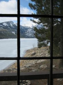
When the view out your window is both tranquil and spectacular, you know you have arrived. That is the feeling you will get upon arrival at one of these 82 rustic & secluded cabin rentals in mesmerizing Montana.
The cabins are located in popular outdoor recreation areas with options for hiking, boating, fishing, and swimming in the surrounding areas, to name just a few possibilities. The cabins were built in the early 1900’s, and are maintained by the US Forest Service.
Each cabin has its own unique story to tell, fully revealed after you click on the images below. Be sure to read the full description before you reserve your spot. Access & amenities vary widely.
ANTONE CABIN, Montana Campground Images, Info & Reservations
Listen Directions From Dillon, travel about 40 miles southeast on Forest Road 202 (Blacktail Creek Road), to Antone Station turnoff. Turn north onto Forest Road 325 and continue about 6 miles to the cabin. During winter months, snowmobiles may be required for the majority of the drive, depending on conditions. Call ahead for road conditions. Phone 406-682-4253 Activities CAMPING, FISHING, HIKING, HUNTING, WINTER SPORTS Keywords ANTO,ANTONE STATION,ANTONE FS STATION,ANTONE GUARD STATION,BEAVERHEAD-DEERLODGE NF -FS Related Link(s) Rec Area Info & Images Montana State Road Conditions Montana State Tourism Overview The Antone Cabin sits in a beautiful open meadow, at the edge of a thick forest, providing visitors with a unique camping experience in the mountains of southwestern Montana. The cabin opens for use on July 1and stays open through December, and it is most popular during hunting season. In addition to hunting access, the facility provides ample opportunities for hiking, backpacking
WALL CREEK CABIN, Montana Campground Images, Info & Reservations
Listen Directions From Ennis, take US Highway south for about 18 miles to Indian Creek and the McAtee Bridge fishing access site. Turn right and go nearly 1 mile to junction just beyond bridge. Turn left and travel toward Wall Creek Wildlife Management Area for 2.7 miles to T junction. Turn left and stay on main road for 2.5 miles, through many twists and curves, to another T junction. Staying on main road, turn left and travel for about 2 miles. Turn right, through gate, at Wall Creek Station sign, and travel a half mile to another gate. Go through gate and cabin is just beyond. Rout is signed.Maps (Beaverhead-Deerlodge National Forest-South) may be purchased by calling the Madison Ranger District. Phone 406-682-4253 Activities BIKING, BOATING, CAMPING, FISHING, HIKING, HUNTING, WILDLIFE VIEWING Keywords WACR,WALL CREEK RANGER STATION,WALL,WALL CREEK,CREEK CABIN,WALL CABIN,CREEK,BEAVERHEAD-DEERLODGE NF -FS Related Link(s) Rec Area Info & Images Montana
SCHNAUS CABIN, Montana Campground Images, Info & Reservations
Listen Directions From Columbia Falls, travel north on Nucleus Avenue and turn east on Railroad Street at the stop sign. This becomes North Fork Road as it travels over the railroad overpass. Continue north on this gravel road for 42 miles to the intersection with Forest Road 10372 and look for the sign for Schnaus Cabin. Go east for less than a half-mile and turn north at the sign for Schnaus Cabin. Phone 406-387-3800 Activities BOATING, CAMPING, FISHING, HIKING, WINTER SPORTS, WILDLIFE VIEWING Keywords SCHN,SCHNAUS,SCHNAUS HOUSE,FLATHEAD NF – FS Related Link(s) Rec Area Info & Images Montana State Tourism Montana State Road Conditions Overview Schnaus Cabin is located near the Wild and Scenic North Fork of the Flathead River, in the Flathead National Forest. It can host up to 12 guests for a scenic, peaceful mountain vacation. The rustic dwelling provides a superb setting for fishing, hiking, bird watching and
MAY CREEK CABIN, Montana Campground Images, Info & Reservations
Listen Directions From Wisdom, travel west on Highway 43 for about 16 miles to the May Creek Campground. Guests can park in the plowed parking area near the highway at the entrance to the campground during the winter. During the summer months, follow the campground road to the fence at the south end of the campground. Parking is available in the meadow just west of the campground. From the campground, hike or ski south along the marked May Creek Trail, crossing a small bridge. About a quarter-mile past the bridge, the May Creek Trail intersects with the May Creek Ridge Trail; stay on the May Creek Trail and continue south for about two miles. The cabin is located on the edge of a large meadow, in the trees, on the east side of the creek. Large, blue diamond stakes mark the trail across the meadow to the cabin. Maps of
CABIN CREEK CABIN, Montana Campground Images, Info & Reservations
Listen Directions Summer access from West Yellowstone: Take U.S. Highway 287 to Forest Service Road 681, Red Canyon Rd, then to the Red Canyon Trailhead. Foloow Trail #205 approximatley 5 miles to Cabin Creek Trail, then 1 mile via hike, horse, mountain bike, or motorcylce to the cabin. Note: ATVs must park at the junction with trail #205 and use permitted methods to access cabin. Motorcyles can access cabin directly during allowed season. ATV/UTV and motorcylce access is allowed July 16 – December 1 from the Teepee Creek Rd. 986 (Call Ranger station for Trail conditions and possible delays). Winter access from West Yellowstone: The cabin is adjacent to the Big Sky Snowmobile Trail. North from West Yellowstone by snowmobile or car approximately 9.5 miles on U.S. Highway 191. Parking is available at the Fir Ridge Cemetery pullout. The Big Sky Snowmobile Trail starts on the north side of U.S.
MONTURE GUARD STATION CABIN, Montana Campground Images, Info & Reservations
Listen Directions From Clearwater Junction (Highway 83 and Highway 200), travel east on Highway 200 for about 13 miles. Turn north on Forest Service Road 89 and continue for 8 miles. Cross the bridge over Monture Creek and proceed, veering slightly to the left for about 100 yards, to a small parking area. Maps are available online or for purchase by calling the Seeley Lake Ranger District. The total distance from the parking area to the cabin is approximately a mile. The winter entrance to the cabin is on the rear (east side) of the cabin. Phone 406-677-2233 Activities CAMPING, WINTER SPORTS, WILDLIFE VIEWING Keywords MGSC,LOLO NF – FS Related Link(s) Rec Area Info & Images Montana State Road Conditions Montana State Tourism Overview Monture Guard Station sits in the Lolo National Forest in western Montana, offering excellent winter recreation for visitors. Recreation Monture Guard Station offers modern amenities and
MOOSE CREEK CABIN, Montana Campground Images, Info & Reservations
Listen Directions From Helena, take U.S. Highway 12, and travel west for 7 miles to Rimini county road. From this intersection, take Rimini Road to the south approximately 4 miles to the cabin. It is located on the east side of the road just past the entrance to Moose Creek Campground. Parking is available to the north of the cabin. A footbridge across Moose Creek provides access from the parking area to the cabin. Vehicles are not allowed within the fenced area. Please make sure you park well off the road. Phone 406-449-5201 Activities BIKING, HISTORIC & CULTURAL SITE, CAMPING, FISHING, HIKING, HUNTING, WINTER SPORTS Keywords Related Link(s) Rec Area Info & Images Montana State Road Conditions Montana State Tourism Overview Moose Creek Cabin is situated in an grassy clearing surrounded by conifer forest in the Tenmile Creek drainage west of Helena, Montana. The cabin was constructed in 1907 and
SILVERTIP CABIN, Montana Campground Images, Info & Reservations
Listen Directions From Hungry Horse, drive east on Highway 2 to Martin City, then south on Forest Road 38. Drive about 55 miles on a winding, gravel road, along Hungry Horse Reservoir. At the junction with Diamond R Guest Ranch, turn east on Forest Road 568 and travel approximately 15 miles. Park at the trailhead and hike or ride on Trail No. 228 for about a third of a mile, to the Spotted Bear River Trail 83. Go past trails 43 and 89. Silvertip Cabin is just south of the Trail 89 intersection. If traveling in July or August, the trail requires a 1.5-mile hike to the cabin. If traveling in June or September, a gate will prohibit access on Forest Road 568 and the trek to the cabin may be up to 4 miles. Phone 406-758-5376 Activities CAMPING, FISHING, HIKING, WILDLIFE VIEWING Keywords STCB,Silvertip,Silvertip Cabin,SILVERTIP CABIN (MT) Related Link(s)
EAST FORK CABIN, Montana Campground Images, Info & Reservations
Listen Directions From Sula, travel northwest on Highway 93 for less than a mile. Turn northeast (right) onto East Fork Road/County Road 472 and continue about 16 miles to the cabin. Maps may be purchased by calling the Darby-Sula Ranger District at 406-821-3913. Phone 406-821-3913 Activities HISTORIC & CULTURAL SITE, CAMPING, FISHING, HIKING, WINTER SPORTS Keywords EFKC,BITTERROOT NF -FS Related Link(s) Rec Area Info & Images Montana State Road Conditions Montana State Tourism Overview East Fork Cabin offers visitors a unique chance to camp in the Bitterroot National Forest of southwestern Montana. The cabin takes visitors back to a rustic, old-time setting and provides access to a variety of recreational opportunities on public lands. The site is available year-round and offers additional camping areas to accommodate large groups. An adjacent picnic area and pavillion provides a convenient location for everyone to gather. The cabin can be accessed by vehicle, however
WOODS CABIN, Montana Campground Images, Info & Reservations
Listen Directions From Darby, Montana, continue north on Highway 93 for 4 miles. Turn west onto County Road 82/Lake Como Road. Follow signs to the Lake Como National Recreation Area and continue past the swimming area, to a gate at the third lot. Maps of the area can be purchased by calling the Darby Ranger District. Phone 406-821-3913 Activities BIKING, BOATING, CAMPING, FISHING, HIKING, WINTER SPORTS, WATER SPORTS, WILDLIFE VIEWING, SWIMMING SITE Keywords WOOD,Wood’s cabin,Lake Como Cabin,Lake Como Wood’s Cabin,Como Cabin,WOOD S CABIN,BITTERROOT NF -FS Related Link(s) Rec Area Info & Images Montana State Tourism Montana State Road Conditions Overview Woods Cabin offers a unique chance to camp in the forest, in a rustic, old-time setting, while enjoying all the summer and winter activities that are available from the shore of scenic Lake Como. The cabin provides a comfortable experience and spectacular views, with its large windows and decks overlooking
TWOGOOD CABIN, Montana Campground Images, Info & Reservations
Listen Directions From Missoula, Montana, travel south on Highway 93 to Medicine Creek Road/Forest Service Road 370, which is approximately 36 miles south of Hamilton. Turn right and continue about 4 miles to the trailhead, which is located at Crazy Creek Campground. An easy, 6-mile hike leads to the cabin from the parking area. The trail follows Warm Springs Creek until it intersects with two other creeks, and then follows Porcupine Creek about a mile to the cabin. Trails are open to hiking, horseback riding, mountain biking. Off-road vehicles are not allowed. Phone 406-821-3913 Activities CAMPING, FISHING, HIKING, HORSEBACK RIDING, WINTER SPORTS, WILDLIFE VIEWING, MOUNTAIN BIKING, BACKPACKING Keywords TWOC,BITTERROOT NF -FS Related Link(s) Rec Area Info & Images Montana State Road Conditions Montana State Tourism Overview Twogood Cabin offers guests a unique chance to camp in the forest of western Montana, in a rustic, old-time setting. It is available between
BIG CREEK CABIN, Montana Campground Images, Info & Reservations
Listen Directions From Livingston, drive south on Highway 89 for approximately 34 miles to Big Creek Road and a sign for Mountain Sky Guest Ranch. Turn right at the sign and follow Big Creek Road for about 5 miles to the cabin. High-clearance, four-wheel drive vehicles are strongly recommended. In winter, the road is plowed to Mountain Sky Guest Ranch. Park in the small parking lot just west of Mountain Sky Guest Ranch. Cross-country skis or snowshoes are required the last half-mile to the cabin from the end of the plowed road. The road gate just past Mountain Sky Guest Ranch closes from Dec. 2 to May 15, annually, for protection of the road. Phone 406-222-1892 Activities HISTORIC & CULTURAL SITE, CAMPING, FISHING, HIKING, HORSEBACK RIDING, WINTER SPORTS, WILDLIFE VIEWING Keywords BIGK,Big Creek Guard Station,Big Creek Ranger Station,GALLATIN NF – FS Related Link(s) Rec Area Info & Images Montana State
PORCUPINE CABIN, Montana Campground Images, Info & Reservations
Listen Directions From Livingston, Montana, travel north on Highway 89 to Wilsall. Just north of Wilsall, turn northeast onto Shields River Road. Continue 8 miles to Porcupine Road, turn east (right) and then drive another 8 miles to the cabin. Four-wheel drive vehicles are recommended due to the road condition. During the winter, the last two miles of the road to the cabin are not plowed. Skis, snowshoes or snowmobiles are required to reach the cabin. Phone 406-222-1892 Activities BIKING, CAMPING, HIKING, WINTER SPORTS, WILDLIFE VIEWING Keywords PORK,PORCUPINE GUARD STATION,PORCUPINE,GALLATIN NF – FS Related Link(s) Rec Area Info & Images Montana State Tourism Montana State Road Conditions Overview Porcupine Cabin sits in the foothills of the Crazy Mountains at an elevation of 6,400 feet. It was built in 1914 after a previous structure burned down, and was remodeled by the Civilian Conservation Corps in 1934. Since its construction, the cabin
MILL CREEK CABIN, Montana Campground Images, Info & Reservations
Listen Directions From Livingston, travel south on Highway 89 for approximately 15 miles. Turn left (east) on Mill Creek Road 468. From this point, it is approximately 12 miles to the cabin along a paved then gravel road. The cabin (marked as the Mill Creek Work Center) will be on the right, just before the Snowbank Campground. In winter, the road is plowed to the Snowbank snowmobile parking area, which is beyond the cabin. Phone 406-222-1892 Activities CAMPING, FISHING, HIKING, WINTER SPORTS, WILDLIFE VIEWING Keywords MILC,Mill Creek Work Center,Mill Creek Guard Station,GALLATIN NF – FS Related Link(s) Rec Area Info & Images Montana State Road Conditions Montana State Tourism Overview Mill Creek Cabin was built in 1927 as a temporary lodging for traveling Forest Service personnel. The cabin can be accessed by vehicle year-round, though a four-wheel drive vehicle is recommended. Guests are responsible for their own travel arrangements and
TRAIL CREEK CABIN, Montana Campground Images, Info & Reservations
Listen Directions From Newman Creek, foot, ski and horse travel are accommodated. To reach the trailhead, travel south off Interstate 90 (exit 316) on Trail Creek Road for approximately 7 miles, then west on Newman Creek Road to the trailhead (1 mile). The trail to the cabin is 2.2 miles, with the first 1.7 miles crossing private property, so please stay on the trail. For those coming from the south; the Newman Creek Road turnoff is 5.5 miles north of the Trail Creek Road/Divide Road junction. During winter months, Newman Creek Road may not be plowed and an additional 1-mile ski might be necessary to reach the cabin. During wet weather, this trail may be very muddy . From Goose Creek, snowmobile and off-road vehicle travel (check travel map or call district for dates allowed) are accommodated. To reach this trailhead, travel south off Interstate 90 (Exit 316) on the
MEYERS CREEK CABIN, Montana Campground Images, Info & Reservations
Listen Directions From the north, take State Highway 78 through Absarokee, Montana, to junction with State Highway 419 3 miles south of Absarokee. Turn right (west) and follow State Highway 419 for 21 miles to Nye. Turn right (north), following the directional sign for 1 mile. Turn left (west) at "Y" intersection and travel approximately 5 miles. Turn right (north) at Meyers Creek/Picket Pin Road intersection and follow road for 2 miles, turning left into Meyers Creek Work Center. From the south, take State Highway 78 from Red Lodge, Montana, to junction with State Highway 419 3 miles south of Absarokee. Turn right (west) and follow State Highway 419 for 21 miles to Nye, MT. Turn right (north), following the directional sign for 1 mile. Turn left (west) at "Y" intersection and travel approximately 5 miles. Turn right (north) at Meyers Creek/Picket Pin Road intersection and follow road for 2
BEAR CREEK CABIN, Montana Campground Images, Info & Reservations
Listen Directions From Ennis, take Highway 287 south for 11 miles, to Cameron, Montana. From Cameron, turn east on Bear Creek Loop and continue approximately 6 miles to the cabin. The last several miles are gravel or dirt roads, which may be muddy or snow-covered and may not always be plowed. Maps (Beaverhead-Deerlodge National Forest-South) may be purchased by calling the Madison Ranger District. Phone 406-682-4253 Activities CAMPING, HIKING, HUNTING Keywords BECA,BEAR CREEK FOREST SERVICE STAT,BEAR CREEK STATION,BEAR CABIN,BEAR,CREEK CABIN,CREEK,BEAVERHEAD-DEERLODGE NF -FS Related Link(s) Rec Area Info & Images Montana State Tourism Montana State Road Conditions Overview The Bear Creek Cabin allows visitors to experience southwestern Montana’s vast wilderness areas, including wide open fields and a variety of nearby mountain ranges. Situated on the Trail Fork of Bear Creek, the cabin offers a scenic location to enjoy activities such as hunting, skiing, snowshoeing, as well as hiking and horseback riding
NOTCH CABIN, Montana Campground Images, Info & Reservations
Listen Directions Notch Cabin is about 62 miles from Ennis, Montana. The final 28 miles are gravel, dirt or primitive two-track. From Ennis, take Montana Highway 287 west for 23 miles to Alder. At Alder, turn south toward Ruby Reservoir (County 248) and travel 21 miles. Turn right on Ledford Creek Road (County 50) and travel southwest for 3 miles to signed junction. Turn right and after about 4.5 miles, you’ll enter the Robb-Ledford WMA. Continue for 0.5 mile to junction, turn right and travel for 5 miles. This stretch of the road will split, with the option of going around or over a hill, then reconnecting a short distance later. After the 5 miles, the Springbrook road joins in from the west. Continue south toward the mountains and cross Ledford Creek after about 3.5 miles. Go 0.5 mile farther, and you’ll reach the Forest Boundary. The cabin lies 1
YELLOW MULE CABIN, Montana Campground Images, Info & Reservations
Listen Directions From Bozeman, MT: Drive west towards Four Corners, then south towards Big Sky/West Yellowstone on US Highway 191 for about 40 miles to the Big Sky turnoff. From here there are three different travel options depending on the season and mode of travel. 1. (June 16 – December 1, weather and snow conditions permitting) Drive south on US Hwy 191 3.75 miles. Turn right (west) onto Buck Creek Ridge Road FS 2599. Drive for 7.7 miles to the Buck Creek Ridge Trailhead. All highway vehicles must park here. Travel for 9.5 miles on Buck Creek Ridge Trail 10. At the junction of Trail 467 to Yellow Mule Cabin, take a right (north) and switchback down about 1/3 mile to the cabin. Winter Route, December 2 to June 16: Park in the lot across from the entrance to Buck Creek Ridge Road on the east side of US Hwy
WINDY PASS CABIN, Montana Campground Images, Info & Reservations
Listen Directions There is no motorized access to this cabin. From Bozeman, MT: Drive west towards Four Corners, then south towards Big Sky/West Yellowstone on US Highway 191 for about 35 miles. Turn left (east) onto Portal Creek Road, FS 984. Travel for 3.5 miles to the FS Road 6959 and FS Road 984 junction. Take the right fork (southeast) and stay on FS Road 984 toward Upper Portal Creek/Windy Pass Trailhead and drive for 5.3 more miles. Stay to the left on FS Rd. 984 past the junction of FS Road 2686 (to the Hidden Lakes Trailhead). From the Windy Pass/Upper Portal Creek trailhead hike Trail 82 for 2.5 miles to the junction with Windy Pass Trail 420. Turn left unto Trail 420 and hike about 1/4 mile to the Windy Pass Cabin. Elevation gain: 1,300 ft. This cabin is closed from October 15 through June 15 each year.
WINDOW ROCK CABIN, Montana Campground Images, Info & Reservations
Listen Directions From Bozeman, MT: Drive south on S. 19th Ave. for about 7 miles. Turn left onto Hyalite Canyon Road FS 62. Drive about 12.7 miles to the Window Rock Cabin access road and gate on the right (west) side of the road. Use the cabin combination to unlock the gate. Please close the gate behind you. Continue past the gate for about 200 meters to Window Rock Cabin. Winter Route, December to March 31: the directions are the same except that you must park at the junction of Hyalite Road FS 620 and the Window Rock Cabin access road (which is 12.7 miles from S. 19th Ave.) From there you may hike, ski, or snowshoe the final 200 meters to the cabin. Please park in the wide pullouts to the side of the road so that snowplows and other Forest visitors can pass. ROAD CLOSURE INFORMATION: (Please refer
SPANISH CREEK CABIN, Montana Campground Images, Info & Reservations
Listen Directions From Bozeman, MT: Drive west towards Four Corners, then south towards Big Sky/West Yellowstone on US Highway 191 for about 19.5 miles. Turn right onto Spanish Creek Road and drive 9 miles to the National Forest boundary. Continue on towards the Spanish Creek Trailhead. To the left (east) side of the road look for a jack leg fence and the access gate for the Spanish Creek Cabin. Use the cabin combination to unlock the gate. Please close the gate behind you. Winter Route, December 2 through May 15: Cabin renters must park 5 miles from US Highway 191 at the Forest Service gate. The Spanish Creek Road FS 982 is closed to wheeled motor vehicles. Do not block any gates. The private landowner must have access beyond the gates year around. Visitors may ski, snowshoe, hike, or bike (depending upon snow conditions) 3.5 miles to cabin. ROAD CLOSURE
MYSTIC LAKE CABIN, Montana Campground Images, Info & Reservations
Listen Directions There is no motorized access to this cabin. 1. Sourdough Canyon Trailhead: From Bozeman, MT. Drive south on S. 19th Ave. for 5.1 miles to Nash Rd. Turn left (east) onto Nash Rd. Drive 1.7 miles to Sourdough Canyon Road, turn right (south), and drive for 0.9 miles to the Sourdough Canyon Trailhead. From the Sourdough Canyon Trailhead travel south on Trail 454, at mile 5 just before the bridge you have two options: 1. Before the bridge turn left onto the Mystic Lake Trail 457. Follow this single track trail approximately 2.8 miles to Mystic Lake. Cross the outlet of the lake to find the cabin up the hill on the south end of the lake. 2. Cross the bridge and go left at the junction to stay on Trail 454. Travel this old roadbed for another 5 miles to the cabin. This is the recommended winter
LITTLE BEAR CABIN, Montana Campground Images, Info & Reservations
Listen Directions From Bozeman, MT: Drive west towards Four Corners, then south towards Big Sky/West Yellowstone on US Highway 191 for 14 miles to Little Bear Road which is on the left (east) side of Highway 191. This road turns into Forest Service Road 980. Summer, June 16 to December 31: Drive about 5.2 miles on the Little Bear Road. Turn right onto Wilson Creek Divide Road FS 3138 for approximately 6 more miles. The gate to the cabin will be on the right (north). The cabin combination will open the gate. Please close the gate behind you. Winter, December 31 to June 16: Park at or before the gate 3 to 5 miles from Highway 191 (depending on snow conditions). ROAD CLOSURE INFORMATION: (Please refer to the Motor Vehicle Use Map ) Little Bear Road FS 980 is closed to all wheeled motorized vehicles from January 1st through June
BATTLE RIDGE CABIN, Montana Campground Images, Info & Reservations
Listen Directions Late spring, summer, and fall access by regular vehicle (May to November): From Bozeman, MT: Drive north on 19th Ave. to West Oak St. Turn right onto West Oak and drive east to N. Rouse Ave. Turn left onto US Highway 86 and drive for 20 miles. Remain on Highway 86 towards Battle Ridge Pass by staying left at the Brackett Creek Y. The cabin access road is about 0.9 miles more and is on the left (east) side of the highway 1/4 mile before the Battle Ridge Trailhead and Battle Ridge Pass. Open the gate using the cabin combination and drive another 1/2 mile to the cabin. Winter Route, December to April (depending on snow conditions): Winter parking is only available at the Battle Ridge Trailhead. Parking along Highway 86 is prohibited so that highway snow plows can work. Please park at the Battle Ridge Trailhead. Please
FORD CABIN, Montana Campground Images, Info & Reservations
Listen Directions From Columbia Falls, travel north on Nucleus Avenue until the road ends at the intersection of Railroad Street. Turn right (east) on Railroad Street. Continue on Railroad Street; it becomes the North Fork Road. Continue north on the North Fork Road for 45 miles. Turn right on Road 308 just north of the Tepee Creek crossing. Follow Road 308 back across Tepee Creek to Ford Cabin. North Fork Road is gravel and rough in spots. It is only intermittently plowed during the winter months, requiring four-wheel drive or chains for travel. Phone 406-387-3800 Activities BOATING, HISTORIC & CULTURAL SITE, CAMPING, FISHING, HIKING, WINTER SPORTS, WILDLIFE VIEWING Keywords FORD,FORD CABIN,FORD WORK CENTER,FLATHEAD NF – FS Related Link(s) Rec Area Info & Images Montana State Road Conditions Montana State Tourism Overview Ford Cabin offers a cozy, rustic getaway along the appropriately named Wild and Scenic North Fork of the Flathead
ZIPS PLACE CABIN, Montana Campground Images, Info & Reservations
Listen Directions From Hungry Horse, travel east on U.S. Highway 2 for 48 miles, to mile marker 191. Travel south on Geifer Greek/Lodgepole Lane (a gravel road that veers left initially). Follow the signs to the cabin. During the winter months or when the road conditions are impassable, renters must park at the designated parking area and hike, snowmobile, ski or snowshoe about a mile to the cabin. Please respect the adjacent property owners and do not block the driveway. Phone 406-387-3800 Activities BOATING, CAMPING, FISHING, HIKING, WINTER SPORTS, WILDLIFE VIEWING Keywords ZIPC,ZIP,ZIP’S PLACE,AUNT ZIP’S PLACE,ZIP’S,AUNT ZIP,ZIP S PLACE CABIN,FLATHEAD NF – FS Related Link(s) Rec Area Info & Images Montana State Road Conditions Montana State Tourism Overview Zip’s Place Cabin is located 48 miles east of Hungry Horse, in northwestern Montana. It provides a beautiful setting on property that was originally a homestead granted in 1937. In 1945 the
NINKO CABIN, Montana Campground Images, Info & Reservations
Listen Directions From Columbia Falls, travel north on Nucleus Avenue and turn east on Railroad Street at the stop sign. The road becomes the North Fork Road as it travels about 45 miles and over the railroad overpass. Turn left on Whale Creek Road 318 and park in the plowed pullout. Then ski, snowshoe or snowmobile about 7 miles from the parking area to the gated road No. 10832. Continue northwest for about 2 miles to Ninko Cabin. Signs are posted along the way. The North Fork Road is gravel, rough in spots and only intermittently plowed during the winter months. A four-wheel drive vehicle and chains are recommended for passage in winter. Phone 406-387-3800 Activities HISTORIC & CULTURAL SITE, CAMPING, HIKING, WINTER SPORTS, WILDLIFE VIEWING Keywords NINK,NINKO,FLATHEAD NF – FS Related Link(s) Rec Area Info & Images Montana State Tourism Montana State Road Conditions Overview Ninko Cabin is located
CHALLENGE CABIN, Montana Campground Images, Info & Reservations
Listen Directions From Hungry Horse, travel east on Highway 2 for 51 miles, then 8 miles south on Skyland Road 569. Park in the plowed area along Highway 2, then hike, snowmobile, ski or snowshoe approximately 8 miles along the groomed trail. The cabin is not accessible by car. Phone 406-387-3800 Activities CAMPING, HIKING, WINTER SPORTS, WILDLIFE VIEWING Keywords CHAC,CHALLENGE,SKYLAND,FLATHEAD NF – FS Related Link(s) Rec Area Info & Images Montana State Road Conditions Montana State Tourism Overview Challenge Cabin is available during the winter and is located about 60 miles southeast of Hungry Horse, in northwestern Montana. It provides a primitive escape for visitors who enjoy winter recreation. The cozy shelter awards visitors with beautiful mountain views, peaceful sounds of nature and virgin, white snow for great photography and snow play. Access to the cabin involves an 8-mile trek by hiking, skiing, snowshoeing or snowmobiling. Guests are responsible for
BEN ROVER CABIN, Montana Campground Images, Info & Reservations
Listen Directions Ben Rover Cabin is located 35 miles north of Columbia Falls, on North Fork Road (County Road 486). From Columbia Falls, travel north on Nucleus Avenue. Turn east at the stop sign, on Railroad Street. The road becomes the North Fork Road as it travels over the railroad overpass. At mile 35 on the North Fork Road, turn east one mile following signs to the town of Polebridge. Turn left (north) to Ben Rover Cabin which is a half-mile from Polebridge on the right. If you cross into Glacier National Park, you have gone too far. North Fork Road is gravel, intermittently plowed during the winter. A four-wheel-drive vehicle with chains is recommended in winter. Phone 406-387-3800 Activities BOATING, CAMPING, FISHING, HIKING, WINTER SPORTS, WILDLIFE VIEWING Keywords BENR,ROVER,BEN,FLATHEAD NF – FS Related Link(s) Rec Area Info & Images Montana State Tourism Montana State Road Conditions Overview Ben Rover
STAR MEADOWS GUARD STATION, Montana Campground Images, Info & Reservations
Listen Directions STAR MEADOW GUARD STATION 5250 Star Meadows Road Whitefish, Montana 59937 Travel from Whitefish west on Highway 93 approximately 12 miles to mile marker 139, turn left onto Farm to Market Road. Continue 1.7 miles; turn right at the "Tally Lake Campground" sign onto the "Star Meadows Road". Continue to mile marker 15 located almost across from the cabin driveway. Phone 406-758-5204 Activities BIKING, CAMPING, FISHING, HIKING, HORSEBACK RIDING, HUNTING, WINTER SPORTS, WILDLIFE VIEWING Keywords STAC,STAR MEADOWS CABIN,GUARD STATION,HISTORIC CABIN,FLATHEAD NF – FS Related Link(s) Rec Area Info & Images Montana State Tourism Montana State Road Conditions Overview This two-room historic Forest Service Guard Station is located 23 miles from Whitefish, Montana, and is accessed by a paved road. Star Meadows was built to serve as a work station and a place to pasture stock. The buildings on this site were built in 1941 and were in service
TWIN LAKES CABIN (MT), Montana Campground Images, Info & Reservations
Listen Directions From Wisdom, MT, travel south on Highway 278 approximately 6 miles. If coming from Jackson, MT travel north on Highway 278 for approximately 12 miles. Turn west onto the Twin Lakes Road, follow for 8 miles, turn left Forest Road 945 continuing approximately 5 miles to Forest Road 183. Turn west onto Forest Road 183 for approximately 6 miles, turn northwest onto Forest Road 183A for approximately 1 mile. The cabin is located in Twin Lakes campground on the shores of the lake. Once you are in the campground turn left at the bulletin board. The cabin is located between Site #2 and Site #5. A map of the area may be necessary to reach the cabin and can be purchased by calling the Wisdom Ranger District. Snowfall prohibits convenient access to the cabin throughout most of the year. Guests must snowmobile, ski, snowshoe or hike up to
HOGAN CABIN, Montana Campground Images, Info & Reservations
Listen Directions Travel west on Highway 43 from Wisdom, Montana for approximately 20 miles. Turn north on the Trail Creek Road #106, travel for approximately 6 miles to the cabin. It will be located on the left (west) side of the road. Access 1 This route takes off from the Chief Joseph Pass cross country ski parking area. Travel north on the Broadway Trail for about one mile until the trail intersects with FS road #1260. The first mile is for skiers only. The remaining road is shared by both skiers and snowmobiles. The route is marked with blue and orange diamonds. This route is recommended for the novice or inexperienced skier. The total distance is 6 miles. Access 2 Shoofly Trail #3117 is the shortest route into Hogan Cabin and also the most difficult. This trail takes off from the parking area along Highway 43 by the Cabinet Creek
CANYON CREEK CABIN, Montana Campground Images, Info & Reservations
Listen Directions From Melrose, travel west on Forest Road 187 for about 13 miles, then continue southwest for 6 miles on Forest Road 7401. Four-wheel drive or high clearance vehicles are required to access the cabin. Depending on conditions, skis and snowmobiles may be necessary to complete the route. Maps may be purchased by calling the Dillon Ranger District. Phone 406-832-3178 Activities BIKING, HISTORIC & CULTURAL SITE, CAMPING, FISHING, HIKING, HUNTING, WILDLIFE VIEWING Keywords CACC,CAKC,CANYON CABIN,CREEK CABIN,CANYON,BEAVERHEAD-DEERLODGE NF -FS Related Link(s) Rec Area Info & Images Montana State Road Conditions Montana State Tourism Overview Canyon Creek Cabin is located in the middle of an old mining district. Historic sites that can be explored on foot or on a bike are nearby. A variety of trails exist in the area, as does abundant wildlife. The cabin is a quaint location for guests to enjoy the scenic Pioneer Mountains in southwestern Montana.
GORDON REESE CABIN, Montana Campground Images, Info & Reservations
Listen Directions From Wisdom, travel west on Highway 43 for 26 miles, the parking area is located at the top of Chief Joseph Pass. The route has many signs. Maps of the area may be purchased by calling the Wisdom Ranger District. Phone 406-689-3243 Activities BIKING, HISTORIC & CULTURAL SITE, CAMPING, FISHING, HUNTING, WINTER SPORTS, WILDLIFE VIEWING Keywords GORD,CHIEF JOSEPH WARMING HUT,GORDON,REESE,GORDON CABIN,BEAVERHEAD-DEERLODGE NF -FS Related Link(s) Rec Area Info & Images Montana State Tourism Montana State Road Conditions Overview Gordon Reese Cabin provides a modern, well-equipped place to stay while enjoying the scenic western Montana mountain ranges. During the summer a variety of recreational opportunities exist in the surrounding area, including hunting, hiking and viewing abundant wildlife. The cabin is a feature along the Lewis and Clark Trail. During the winter months the Gordon Reese Cabin and surrounding areas transform into a winter wonderland. Surrounding the cabin are 32
HELLS CANYON GUARD STATION, Montana Campground Images, Info & Reservations
Listen Directions From Whitehall, travel south on Highway 55 for about 20 miles. Turn right off the highway just before crossing the Jefferson River, onto Forest Service Road 125, and continue west about 14 miles on a dirt road. Winter access varies with snow conditions. Guests may need to hike, ski or snowmobile to the cabin during winter months. Maps may be purchased by calling the Butte/Jefferson Ranger District. Phone 406-494-2147 Activities BIKING, CAMPING, FISHING, HIKING, HORSEBACK RIDING, HUNTING, WINTER SPORTS Keywords HELL,HELL’S CANYON CABIN,HELL’S,CANYON,GUARD,HELL S CANYON GUARD STATION,BEAVERHEAD-DEERLODGE NF -FS Related Link(s) Rec Area Info & Images Montana State Road Conditions Montana State Tourism Overview Hells Canyon Guard Station is a quaint log cabin located in the Highland Mountains of Montana’s Beaverhead-Deerlodge National Forest. It is most often used as a base camp by hunters and hikers. The area is replete with wildlife and provides access to scenic mountain
WHITETAIL CABIN, Montana Campground Images, Info & Reservations
Listen Directions From Ashland, Montana, take Highway 212 east for approximately 5 miles to East Fork Otter Creek Road. Turn northeast onto East Fork Otter Creek Road and travel 12 miles to Whitetail Cabin. Phone CALL FOR COMBINATION PRIOR TO YOUR STAY – M-F 8:00 TO 4:30 CALL 406-784-2344. AFTER HOURS OR WEEKENDS CALL 406-740-1594. Activities BIKING, HISTORIC & CULTURAL SITE, CAMPING, HIKING, HORSEBACK RIDING, HUNTING Keywords WHTC,WHITETAIL,WHITE CABIN,TAIL,WHITE,CUSTER NF – FS Related Link(s) Rec Area Info & Images Montana State Tourism Montana State Road Conditions Overview Whitetail Cabin sits at an altitude of 4,048 feet in the north end of the Custer National Forest approximately 20 miles from Ashland, Montana. The cabin was built in the 1930s by the Civilian Conservation Corps. Formerly a ranger station, it is now a registered historic site. The cabin is available year-round and is accessible by car, but guests should be prepared to
VIGILANTE CABIN, Montana Campground Images, Info & Reservations
Listen Directions From Sheridan, travel south on Highway 287 for about 10 miles to Alder. Turn south on Ruby River Road and continue about 22 miles to Vigilante Station. The last 20 miles are on a gravel road, which can be slippery when wet or snow-covered. The gate lock code is the same as the cabin. Maps of the area may be purchased by calling the Madison Ranger District. Phone 406 682-4253 Activities CAMPING, FISHING, HIKING, HUNTING, WINTER SPORTS, WILDLIFE VIEWING Keywords VIGI,VIGILANTE GUARD STATION,BEAVERHEAD-DEERLODGE NF -FS Related Link(s) Rec Area Info & Images Montana State Tourism Montana State Road Conditions Overview The Vigilante Cabin, also known as the Vigilante Middle House, offers a comfortable place to stay deep in the mountains of southwestern Montana. The cabin used to be a guard station and boasts two bedrooms, a kitchen, living room and electricity. It is close to many outdoor recreation
BLACK BUTTE CABIN, Montana Campground Images, Info & Reservations
Listen Directions From Ennis, travel south on Highway 287 for about 32 miles to the West Fork Rest Area. Turn right onto West Fork Road/Forest Road 209 and continue for about 2 miles. Turn right onto Standard Creek Road/Forest Road 237 and travel 18 miles to the cabin. Maps may be purchased by calling the Madison Ranger District. Phone 406-682-4253 Activities CAMPING, HIKING, HUNTING, WINTER SPORTS Keywords BLKB,BLACK BUTTE,BEAVERHEAD-DEERLODGE NF -FS Related Link(s) Rec Area Info & Images Montana State Tourism Montana State Road Conditions Overview Black Butte Cabin is a snug log cabin that sits high in the Gravelly Mountains. It sleeps four people and has scenic views of Lion Mountain. The area is home to a variety of wildlife and provides access to numerous trails for hiking, horseback riding and off-road vehicles during warmer months, and snowmobiles in the winter. The cabin is open nine months out of
BASIN STATION CABIN, Montana Campground Images, Info & Reservations
Listen Directions Summer directions from West Yellowstone: Proceed west on U.S. Highway 20 for approximately 6.5 miles. Turn right on Denny Creek Road and continue approximately two miles north. The cabin is located on the right side of the road. Winter directions from West Yellowstone: Proceed west on U.S. Highway 20 for approximately 7.5 miles. Parking is available at the Buttermilk Trailhead, located approximately one mile up Highway 20 from Denny Creek Road, to the left. Guests will need to ski, snowmobile, or snowshoe one mile down Highway 20 from the Buttermilk Trailhead parking lot, and proceed along the two mile trail to the cabin. During the spring and fall, guests are encouraged to call the Hebgen Lake Ranger District at (406) 823-6961 for road conditions and access to the cabin. Road conditions can vary greatly. Phone 406-823-6961 (FOR CABIN AND ROAD INFORMATION – NO BOOKING, ALL RESERVATIONS ARE MADE
WAPITI CABIN, Montana Campground Images, Info & Reservations
Listen Directions Summer access (May 16 to December 1): For summer access from West Yellowstone, proceed north on Highway 191 for approximately 33.5 miles. Turn left on Taylor Fork Road/Forest Service Road 134 and proceed approximately 3.5 miles. Turn left on Forest Service Road 2522 and proceed approximately 1.5 miles. The cabin is located on the right side of the road. Winter access (December 2 to May 15): From Sage Creek Trailhead parking area off of Highway 191, follow the newly relocated Big Sky/Carrot Basin Trail for eight miles. Please note that the cabin is located on the edge of a winter wildlife closure area. Off trail snowmobiling around the cabin is permitted only to the south of the access road (on the left side, if traveling to and beyond the cabin). Trail grooming occurs December 1 – March 31 depending on snow conditions. View grooming report at destinationyellowstone.com/snowmobile. Trail
BEAVER CREEK CABIN (MT), Montana Campground Images, Info & Reservations
Listen Directions Summer access from West Yellowstone: Proceed 8 miles north on U.S. Highway 191. Turn left onto U.S. Highway 287/Hebgen Lake Road and continue for 14.5 miles. Turn right on Beaver Creek Road/Forest Service Road 985 and drive for 3.5 miles. The cabin access road is on the right side of Beaver Creek Road. The cabin is 300 yards down the access road. You must open a locked gate to enter the access road. The combo for the gate is the same combo provided to unlock the cabin in the confirmation letter. Please keep the gate closed and locked at all times. Winter access from West Yellowstone: Proceed 8 miles north on U.S. Highway 191. Turn left onto U.S. Highway 287/Hebgen Lake Road and continue for 14.5 miles. Park at the Refuge Point parking lot, adjacent to the highway. Do not park on the highway. Snowmobile, ski, or snowshoe
DONEY CABIN, Montana Campground Images, Info & Reservations
Listen Directions Phone 406-859-3211 Activities BIKING, CAMPING, HIKING, HUNTING, WINTER SPORTS, WILDLIFE VIEWING Keywords DONE,DONEY LAKE CABIN,BEAVERHEAD-DEERLODGE NF -FS Related Link(s) Rec Area Info & Images Montana State Road Conditions Montana State Tourism Overview DUE TO EARTHQUAKE DAMAGE THIS CABIN IS NO LONGER FOR RENT AND IS OFF THE SYSTEM. Recreation Facilities Natural Features Nearby Attractions Reservation
WEST FORK CABIN (S OF ENNIS), Montana Campground Images, Info & Reservations
Listen Directions From Ennis, travel south on Highway 287 for about 30 miles, then head northwest on Standard Creek Road for about 20 miles and 10 miles south on Forest Road 290. The majority of the road to the cabin is gravel and has some long, steep grades, which may require four-wheel drive. The road can be treacherous and impassable if the conditions are wet or snowy. Snowmobiles or skis may be required for the final portion, up to 30 miles, in the winter. Maps (Beaverhead-Deerlodge National Forest-South) may be purchased by calling the Madison Ranger District. Phone 406-682-4253 Activities BIKING, CAMPING, HIKING, HUNTING, WINTER SPORTS, WILDLIFE VIEWING Keywords WFRK,BEAVERHEAD-DEERLODGE NF -FS Related Link(s) Rec Area Info & Images Montana State Road Conditions Montana State Tourism Overview West Fork Cabin is a small, secluded cabin in the mountains of southwestern Montana, located high in the Gravelly Range. The area is
MOOSE LAKE CABIN, Montana Campground Images, Info & Reservations
Listen Directions From Philipsburg, travel south on Highway 1 for about 7 miles to the junction with Skalkaho Highway/Highway 38. Turn right onto Highway 38 and continue west for about 9 miles and turn left onto Moose Lake Road/Forest Road 5106. Travel another 9 miles to the cabin. Winter weather conditions may require visitors to park on the main road and hike about a quarter-mile to the cabin. Maps may be purchased by calling the Pintler Ranger District. Phone 406-859-3211 Activities CAMPING, FISHING, HIKING, HUNTING, WINTER SPORTS, WILDLIFE VIEWING Keywords MSLK,MOOSE LAKE GUARD STATION,MOOSE LAKE STATION,BEAVERHEAD-DEERLODGE NF -FS Related Link(s) Rec Area Info & Images Montana State Road Conditions Montana State Tourism Overview Moose Lake Cabin is located in the Beaverhead-Deerlodge National Forest in southwestern Montana. The historic cabin, which was built in 1917 for use as a Forest Service work cabin, offers visitors access to the Anaconda-Pintler Wilderness Area,
DOUGLAS CREEK CABIN, Montana Campground Images, Info & Reservations
Listen Directions From Hall, travel south on Highway 1 for about 3 miles to Douglas Creek. Take Forest Road 707 and continue approximately 7 miles to the cabin. Maps may be purchased by calling the Pintler Ranger District. Phone 406-859-3211 Activities BIKING, CAMPING, HIKING, HUNTING, WINTER SPORTS, WILDLIFE VIEWING Keywords DCAB,BEAVERHEAD-DEERLODGE NF -FS Related Link(s) Rec Area Info & Images Montana State Road Conditions Montana State Tourism Overview Douglas Creek Cabin offers a great way to access the various seasonal activities available in the Beaverhead-Deerlodge National Forest in western Montana. While hunting enthusiasts enjoy the cabin during bow and rifle seasons, it is popular for snowmobiling in the winter and hiking in the summer. The cabin is in a very remote location, giving anyone an outdoor recreational experience they will never forget. Access to the cabin is limited by weather conditions. Four-wheel drive and high-clearance vehicles are necessary year-round. Excessive
RACETRACK CABIN, Montana Campground Images, Info & Reservations
Listen Directions Attention: The road to Racetrack Cabin is impassable to 2 wheel drive vehicles, you must have a high cleareance 4×4 vehicle. This is an extremely rough and rutted road. Do not even attempt this drive unless you’re experienced with primitive forest roads. Allow yourself at least 30 minutes to travel the last 4 miles to the cabin. Livestock will have to be high lined at the cabin. For additional information about accessing the cabin, please call (406) 859-3211. From Deer Lodge, travel south on Interstate 90 for about 11 miles to the Racetrack exit 195. Turn west and drive about 1 mile, then turn south and continue less than a mile to Forest Road 169. Turn west onto Forest Road 169 and continue about 16 miles to the cabin. Maps may be purchased by calling the Pintler Ranger District. Vehicle access cannot be guaranteed any time of year
STONY CABIN, Montana Campground Images, Info & Reservations
Listen Directions From Philipsburg, travel west on Rock Creek Road/County Road 348 for approximately 14 miles, then turn right onto Rock Creek Road/County Road 102 and continue about 5 miles. Turn left at Stony Creek Road/County Road 241 and the cabin is about a quarter-mile on the right. Depending on snow conditions, the last quarter-mile may be impassable during the winter. Maps may be purchased by calling the Pintler Ranger District. Phone 406-859-3211 Activities CAMPING, FISHING, HIKING, HUNTING, WINTER SPORTS, WILDLIFE VIEWING Keywords STNY,BEAVERHEAD-DEERLODGE NF -FS Related Link(s) Rec Area Info & Images Montana State Tourism Montana State Road Conditions Overview Stony Cabin is a small primitive cabin that was built in 1914 as a place for Forest Service employees to sleep while working in the area. The cabin is situated close to Stony Creek Road and across the street from Stony Creek Campground. It is not remote but ideal
OWL CREEK CABIN, Montana Campground Images, Info & Reservations
Listen Directions Owl Creek Cabin is located at the Owl Creek Packer Camp, about 4 miles off Montana State Highway 83 in the Swan Valley. From Highway 83 turn east onto Holland Lake Road #44 near mile marker 35. After 2.5 miles, turn right on Owl Loop Road #9558. Go about 0.5 miles and turn right on Road #10121 to Owl Creek Packer Camp. The camp entrance is located on the right. Turn here and continue straight through the camp, turn left at the end and drive past the corrals. The cabin is located near the end of this loop on the right, just past the last corral. There is no sign marking the cabin, but the rental is the only structure in the camp area. Phone 406-837-7500 Activities BOATING, CAMPING, FISHING, HIKING, WINTER SPORTS Keywords OWLC,FLATHEAD NF – FS Related Link(s) Rec Area Info & Images Montana State Tourism
UPPER FORD CABIN RENTAL, Montana Campground Images, Info & Reservations
Listen Directions From Troy, Montana, take US Highway 2 west for 9.5 miles to Yaak Highway 508. Follow Yaak Highway 508 for 30 miles north to the town of Yaak. Follow Yaak 92 approximately 7 miles to the junction with Upper Ford Road 8025, stay to the right. The cabin is approximately 300 yards from this junction and is located on the right-hand side of the road. Phone 406-295-4693 Activities HISTORIC & CULTURAL SITE, CAMPING, FISHING, HIKING, HUNTING, WINTER SPORTS Keywords UPFO,KOOTENAI NF – FS Related Link(s) Rec Area Info & Images Montana State Road Conditions Montana State Tourism Overview The Upper Ford Ranger Station is situated near the Yaak River at an elevation of 2,984 feet within the Rocky Mountains in Kootenai National Forest. This remote cabin was built in 1926 and was at the heart of the Upper Ford Ranger District until 1942, when it was combined with
HORSE PRAIRIE CABIN, Montana Campground Images, Info & Reservations
Listen Directions From Dillon, travel south on Interstate 15 for about 20 miles, to Highway 324. Cross the Clark Canyon Reservoir Dam and travel west on Highway 324 for about 21 miles. At Red Butte, continue west on Forest Road 181 (Bloody Dick Road) for about 6 miles to the junction with Forest Road 7340 (Coyote Creek Road). Continue about 2 miles to the cabin. In winter, over-the-snow distance to the cabin will vary from 1 to 6 miles. Maps may be purchased at the Dillon Ranger District 420 Barrett Street, Dillon, MT 59725 – Monday through Friday from 7:30-16:30 mst. Or using a computer – http://www.fs.usda.gov/bdnf (mobile map applications are available). Phone 406-683-3900 Activities BIKING, CAMPING, FISHING, HIKING, HUNTING, WINTER SPORTS, WILDLIFE VIEWING Keywords HRPR,HORSE PRAIRIE GUARD STATION,BEAVERHEAD-DEERLODGE NF -FS Related Link(s) Rec Area Info & Images Montana State Tourism Montana State Road Conditions Overview Horse Prairie Cabin is
BLOODY DICK CABIN, Montana Campground Images, Info & Reservations
Listen Directions From Dillon, travel south on I-15 for about 19 miles and exit at Clark Canyon Reservoir (Hwy 324). Travel 17 miles west on Highway 324 through Grant, MT. Proceed west and turn north onto Bloody Dick Road/Forest Road 181. Continue about 18 miles following road signs. The Bloody Dick Guard Station is 1/2-mile off FS Road 181. You will have to unlock the double gate and proceed another 1/16 of a mile to the cabin. The combination to the gate is the same as the cabin combination you will recieve in the confirmation letter. Depending on snow conditions, the route may require visitors to ski or snowmobile for 23 miles, from Jackson. Maps may be purchased online at http://www.fs.usda.gov/bdnf or at the Dillon Ranger District – 420 Barrett Street, Dillon, MT 59725 (406) 683 3900. District hours are 7:30-16:30 mst – Monday through Friday. Phone 406-683-3900 Activities BIKING,
HIGH RYE CABIN, Montana Campground Images, Info & Reservations
Listen Directions From Butte, travel west on Interstate 90 for about 12 miles, to exit 211. Continue about 3 miles south on Highway 441. Turn left onto Forest Service Road 82 and travel 4 miles south to the cabin. Maps may be purchased by calling the Butte Ranger District. Phone 406-494-2147 Activities BIKING, CAMPING, FISHING, HIKING, HORSEBACK RIDING, HUNTING, WILDLIFE VIEWING Keywords HIRY,HIGH RYE CABIN,HIGH RYE,BEAVERHEAD-DEERLODGE NF -FS Related Link(s) Rec Area Info & Images Montana State Tourism Montana State Road Conditions Overview High Rye Cabin is a quaint place to stay, ideally situated for exploring the northern Fleecer Mountains. An abundance of recreational activities are available in this scenic area. The cabin was built by the Civilian Conservation Corps around 1919 and is located in the historic mining district of German Gulch. It was used as an administrative site until the 1940s, when it was opened to the public.
BULL RIVER GUARD STATION, Montana Campground Images, Info & Reservations
Listen Directions From US Highway 2 (to the north) or State Highway 200 (to the south), travel on State Highway 56 to the East Fork Bull River Road #407 at approximately the 8 mile marker. Take Road #407 for about 1.5 miles and turn right on Road #2701. The cabin is approximately .5 miles past the junction of #407 and #2701. Directional signs are present. Phone 406-827-3533 Activities BOATING, CAMPING, FISHING, HIKING, HUNTING Keywords BRGS,KOOTENAI NF – FS Related Link(s) Rec Area Info & Images Montana State Tourism Montana State Road Conditions Overview The Bull River Guard Station was built in 1908 as the Ranger’s house and office. This structure was a primary ranger station from 1908 to 1920, surviving the legendary 1910 fires that swept through the area. The cabin was home to Granville “Granny” Gordon (District Ranger), his wife and three daughters. Full vehicle access to the cabin
BIRCH CREEK CABIN, Montana Campground Images, Info & Reservations
Listen Directions From Dillon, travel north on I-15 for 12 miles to exit 74 at Apex. Turn west and continue about 8 miles on Birch Creek Road. Cross the bridge and take the first right onto Thief Creek Road. The cabin is about 1/4-mile to the west at Thief Creek. Depending on snow conditions, guests may need to park at the Birch Creek Road turnoff and ski or snowmobile to the cabin. Maps may be purchased at the Dillon Ranger District or online http://www.fs.usda.gov/bdnf (mobile maps are available). Phone 406-683-3900 Activities BIKING, BOATING, HISTORIC & CULTURAL SITE, CAMPING, HIKING, HUNTING, WINTER SPORTS, WILDLIFE VIEWING Keywords BCCA,BEAVERHEAD-DEERLODGE NF -FS Related Link(s) Rec Area Info & Images Montana State Road Conditions Montana State Tourism Overview Birch Creek Cabin is a historic log cabin with electricity and running water. It provides access to a variety of hiking, ohv, and for cross-country skiing and
CALF CREEK CABIN, Montana Campground Images, Info & Reservations
Listen Directions From White Sulphur Springs, head east on Highway 12 for 3 miles and turn left (north) on Highway 89. Continue about 15 miles, then head west (left) on Road 119 for 9 miles to the cabin. From Great Falls, head east on Highway 87/89 about 23 miles to the rest area just past Belt. Turn right (south, to White Sulphur Springs) onto Highway 89. Go past Monarch and Neihart to Kings Hill Pass (about 75 miles from Great Falls), and down Highway 89 about 13.5 miles past Kings Hill Pass to Road 119 and turn right (west). Drive 9 miles to the cabin. The last 7 miles of the road is closed from December 1st through May 15th. It is a designated groomed snowmobile trail. During this timeframe travel the last 7 miles must be made by skiing, snowmobiling or walking. Due to snow conditions, travel on Forest
WEST BOULDER CABIN, Montana Campground Images, Info & Reservations
Listen Directions From Big Timber, Montana, travel 16 miles south on Highway 298 to McLeod. Just past the turn off to McLeod, turn right (west) onto West Boulder Road for approximately 6 miles. It turns into Swingley Road. Drive on Swingley Road for 1.5 miles, then turn left onto West Boulder Road. The cabin is between West Boulder Campground and the trailhead parking area. During winter months, it is advisable to call the Livingston Office of the Yellowstone Ranger District at (406) 222-1892 for local road conditions. Winter access may only be possible by snowmobile, snowshoes or cross-country skis for up to a mile on county road. Phone 406-222-1892 Activities CAMPING, FISHING, HIKING, WINTER SPORTS Keywords WESB,WEST,BOULDER,GALLATIN NF – FS Related Link(s) Rec Area Info & Images Montana State Road Conditions Montana State Tourism Overview West Boulder Cabin is open year-round, offering a variety of recreational opportunities as well as
WEST BRIDGER CABIN, Montana Campground Images, Info & Reservations
Listen Directions From Big Timber, Montana, travel 14 miles east on Interstate Highway 90 to exit 384 (Bridger Creek). From the stop sign, travel south for 8.2 miles to the junction of Main Bridger with West Bridger Creek Road. Turn right and continue on West Bridger Road for 2.2 miles to the junction of West Bridger with Derby Gulch. Stay right on West Bridger Road for 0.7 miles. On the south side (left) of the road, at the turn off to the cabin, is a reflective sign (white numbers on a green background) 291. The wire mesh gate on the left side of the road has 3 locks (interlocking) on it – please re-lock the gate the same way. The driveway to the cabin is approximately 0.2 miles. Accessibility is generally good. It is advisable to call the Livingston Office of the Yellowstone Ranger District at (406) 222-1892 for local
FOURMILE CABIN, Montana Campground Images, Info & Reservations
Listen Directions From Big Timber, travel 25 miles south on Highway 298 to the National Forest Boundary. At this point, the paved road becomes county-maintained gravel road (Main Boulder Road or Forest Road 6639). Continue on this gravel road another 17 miles. The cabin is on the west (right) side of the road across from the Fourmile Trailhead parking area. The Forest Service sign at the entrance to the cabin reads Fourmile Ranger Station. During winter months it is advisable to call the Livingston Office of the Yellowstone Ranger District at (406) 222-1892 for current conditions. Phone 406-222-1892 Activities CAMPING, FISHING, HIKING, HUNTING, WINTER SPORTS Keywords FOUR,FOURMILE,GALLATIN NF – FS Related Link(s) Rec Area Info & Images Montana State Road Conditions Montana State Tourism Overview Fourmile Cabin is open year-round and offers guests a rustic mountain retreat surrounded by majestic scenery. The cabin offers an electric cooking stove, lights. A
DEER CREEK CABIN (MT), Montana Campground Images, Info & Reservations
Listen Directions Deer Creek Cabin is located approximately 30 miles south of Big Timber, Montana. It can be accessed by 3 different routes. It is recommended that renters carry topographic maps, GPS and compasses for navigation since the route may be difficult to find. One route to follow is the Placer Gulch Trailhead access by foot, horse, or OHV (50 inches or less): From Exit 370 on Interstate 90 just east of Big Timber, take Frontage Road (south side of the interstate) 8 miles east. Turn right (south) onto Lower Deer Creek Road (Forest Service Road #482) and proceed 16.2 miles to the Placer Gulch Trailhead sign located on the left side of the road. Park at the trailhead and travel Placer Gulch Trail 256 by foot, horse or off-road vehicles a distance of 5.2 miles, to the Deer Creek Cabin. Jim’s Gulch Trailhead access by foot or horse: From
HUNTERS SPRING CABIN, Montana Campground Images, Info & Reservations
Listen Directions From the south: From Hwy 12 take Forest Road 274 north for approximately 11 miles to Forest Road 6429 tturn right on 6479 just past Whitetail Campground. Go approximately .5 mies on road 6429 to the Hunter Springs Cabin turn off on the right. and the sign pointing to the Hunters Spring Cabin. From the North: From Utica, MT take the county road west out of Utica which is county road 1 and go about 13 miles to a junction. At the junction, go straight or left toward South Fork Judith Forest Road 487 and follow the road all the way to the Spring Creek junction. Turn Left onto Spring Creek Road #274 and follow it to the Bear Park Road #6429. Turn left and go just past the spring to the left and the gate will be on the right. Phone 406-236-5511 OR 406-566-2292 Activities BIKING, CAMPING,
WEST FORK CABIN (W OF CHOTEAU), Montana Campground Images, Info & Reservations
Listen Directions From Highway 89 about 5 miles north of Choteau, go west on Teton Canyon Road that becomes Forest Development Road (FDR) #144 at the Forest boundary. Stay on this road past the ski area about 3.5 miles to the road end. Cabin is located behind the locked gate to your left just after you cross the bridge. In the winter the road is not plowed beyond the ski area. Guests can park in the ski area parking lot. All vehicles parked overnight at either the snowmobile parking lot or the ski area parking lot will be issued a parking pass to put in their window by the district office when the cabin key is issued. Phone 406-466-5341 Activities CAMPING, HIKING, HORSEBACK RIDING, HUNTING, WILDLIFE VIEWING Keywords WEFC,WEST,FORK,LEWIS AND CLARK NF – FS Related Link(s) Rec Area Info & Images Montana State Tourism Montana State Road Conditions Overview West
BEND GUARD STATION, Montana Campground Images, Info & Reservations
Listen Directions This rental is located approximately 32 miles up the Thompson River Road (County Road 56 on maps, County Road 556 on the ground) from its junction with Montana Highway 200, five miles east of Thompson Falls, Montana. It may also be accessed from U.S. Highway 2 by turning south on the Thompson River Road (County Road 56 on maps, County Road 556 on the ground) between McGregor Lake and Lower Thompson Lake, approximately 40 miles west of Kalispell, Montana. After leaving Highway 2 or 200, area roads are low standard gravel or dirt and are often rough. Area roads also serve logging trucks and should be driven with care. During the winter, it may be necessary to hike, ski or snowmobile for at least a mile to the cabin, as roads are not always plowed. Maps are available online or for purchase by calling the Plains/Thompson Falls Ranger
DRY WOLF CABIN, Montana Campground Images, Info & Reservations
Listen Directions From Stanford, Montana, go a mile northwest on US 87, then turn left on County Road 251 (Dry Wolf Road). Continue for 15 miles and look for a sign to Dry Wolf Station. Turn left onto short parking spur of the cabin site. Phone 406-236-5511 OR 406-566-2292 Activities BIKING, CAMPING, FISHING, HIKING, HUNTING, WILDLIFE VIEWING, MOUNTAIN BIKING, CROSS COUNTRY SKIING, SCENIC DRIVE, SNOWMOBILING Keywords DRYW,DRY,WOLF,LEWIS AND CLARK NF – FS Related Link(s) Rec Area Info & Images Montana State Tourism Montana State Road Conditions Overview Dry Wolf Cabin is located about 20 miles southwest of Stanford, Montana, in the Little Belt Mountains. The rustic cabin is conveniently located along Dry Wolf Creek, providing a pleasant setting for anglers, wildlife watchers and hikers. When snow arrives, access on the graveled county road is by four-wheel-drive only. Recreation Anglers seek brook and rainbow trout in Dry Wolf Creek. A variety
CRYSTAL LAKE CABIN, Montana Campground Images, Info & Reservations
Listen Directions From Lewistown, drive west on Montana Highway 200/US 87 for about 8 miles. Turn left (south) on Crystal Lake Road. Continue south, following the well-signed directions to the lake for 20 miles. At the "T" junction, turn left and continue on to Crystal Lake. The last 6 miles is paved and mostly a single lane. On December 1, the paved section is gated, and access beyond the gate is by snowmobile, skis, snowshoes or hiking only. Phone 406-566-2292 OR 406-236-5511 Activities CAMPING, FISHING, HIKING, WILDLIFE VIEWING, PHOTOGRAPHY, CANOEING, CROSS COUNTRY SKIING Keywords CRYC,CRYSTAL,LAKE,LEWIS AND CLARK NF – FS Related Link(s) Rec Area Info & Images Montana State Tourism Montana State Road Conditions Overview Crystal Lake Cabin provides sweeping views of Crystal Lake in the heart of the Big Snowy Mountains of Central Montana. Located about 20 miles south of Lewistown, the cabin adjoins Crystal Lake Campground, providing conveniences
JUDITH GUARD STATION, Montana Campground Images, Info & Reservations
Listen Directions From Great Falls, travel east on U.S. Highway 87 for about 63 miles to Windham, Montana, from Windham turn right off HWY 200/87 and head south for approximately 10 miles until the town of Utica. Turn right at Utica, continue south for approximately 13 miles on the county road. At the “Y” junction turn right nto the Middlefork road 822 and continue southwest for about 1 mile until you reack the “Y”, stay to the left and continue for about 1 mile to the Judith Gaurd Station Phone 406-566-2292 OR 406-236-5511 Activities BIKING, CAMPING, FISHING, HIKING, HUNTING, OFF HIGHWAY VEHICLE, WILDLIFE VIEWING, PHOTOGRAPHY, SNOWMOBILE, MOUNTAIN BIKING, BIRDING, CROSS COUNTRY SKIING, BACKPACKING, ARCHERY Keywords JUDI,JUDITH,GUARD,STATION,LEWIS AND CLARK NF – FS Related Link(s) Rec Area Info & Images Montana State Tourism Montana State Road Conditions Overview Judith Guard Station is a historic Ranger Station dating back to the early 1900s.
KINGS HILL CABIN, Montana Campground Images, Info & Reservations
Listen Directions From Great Falls, travel aproximately 23 miles east on Highway 87/89 and turn right (south) at the rest area/weigh station just past Belt, onto U.S. Highway 89 toward Monarch and Neihart. Drive approximately 50 miles to Kings Hill Pass. The cabin is on the left side of the highway just before the pass (within 300 feet of the pass). The total distance form Great Falls is about 75 miles. During the summer season, visitors can drive directly to the cabin. During the winter season, there is parking on the wide spot along the highway, which is plowed. From White Sulphur Springs, go about 3 miles east on Highway 12 and turn left (north) onto Highway 89. The cabin is just past Kings Hill Pass on the right. Total distance from White Sulphur Springs is 28.5 miles. Phone 406-236-5511 OR 406-547-3361 Activities CAMPING, FISHING, HIKING, HORSEBACK RIDING, HUNTING, WILDLIFE
WEST FORK OF ROCK CREEK CABIN, Montana Campground Images, Info & Reservations
Listen Directions From Philipsburg, travel south on Highway 1 for just over 6 miles. Turn right onto Skalkaho Highway/Highway 38 and travel west for about 13 miles. The entrance to the cabin is on the left, behind a locked gate, which uses the same key code as the cabin. The last 200 yards of the road may be closed due to snowfall during the winter months. Maps may be purchased by calling the Pintler Ranger District. Phone 406-859-3211 Activities BIKING, CAMPING, FISHING, HIKING, HUNTING, WINTER SPORTS, WILDLIFE VIEWING Keywords WROC,West Fork Guard Station,West Fork,West Fork Station,BEAVERHEAD-DEERLODGE NF -FS Related Link(s) Rec Area Info & Images Montana State Tourism Montana State Road Conditions Overview The West Fork of Rock Creek Cabin is located on the western edge of the Beaverhead-Deerlodge National Forest and is open for reservations year-round. It is a large cabin that provides a great experience in the mountains
KADING CABIN, Montana Campground Images, Info & Reservations
Listen Directions Located 25 miles southwest of Helena, Montana in the Little Blackfoot drainage, the cabin can be reached via US Highway 12, turning left (south) onto Little Blackfoot River Road just east of Elliston. From this intersection, it is approximately 16 miles to the cabin. The cabin is located on the north side of the road, directly across from the entrance to Kading Campground. During the winter months, Little Blackfoot River Road is only plowed on a regular basis as far as Hat Creek. Normally, the county plows the road to this point and makes a turn-around for parking. Approximately 7 more miles of unplowed road remain to reach the cabin. This section of road is closed to vehicles but open to those who like to ski, snowmobile or use dog sleds. Phone 406-449-5201 Activities BIKING, CAMPING, FISHING, HIKING, HORSEBACK RIDING, HUNTING, WINTER SPORTS, WILDLIFE VIEWING Keywords KADI,KADING GUARD
INDIAN FLATS CABIN, Montana Campground Images, Info & Reservations
Listen Directions Indian Flats Cabin is located 40 miles northeast of Helena. Take Highway 280 east from Helena. Several miles after crossing the Missouri River, you will come to the small community of York. Turn left at the York Bar and proceed 5 miles to the smaller community of Nelson, where you should turn right. Stay on the main road up Beaver Creek, through a series of switchbacks up Burnt Gulch, past Pikes Gulch Campground to the junction of Hogback Lookout and Indian Flats Roads. Take the left hand fork for about 0.5 miles, and the cabin will be on the right. Access to the Indian Flats Cabin is dependent on the time of year and weather conditions. Usually during the summer and fall months, passenger cars can drive directly to the cabin. During the winter months, the cabin can only be accessed by snowmobiling or cross-country skiing approximately 8
CUMMINGS CABIN, Montana Campground Images, Info & Reservations
Listen Directions The cabin is located 8.5 miles east of Lincoln, Montana and can be reached via Hogum Creek Road, which is approximately 6 miles east of Lincoln on Highway 200. Follow Hogum Creek Road to the junction of Black Diamond Road and Lower Hogum Creek Road. Lower Hogum Creek Road will take you to the cabin driveway. The driveway is on the left and is signed with a wooden sign and blue ski blazers. During the winter months, snow plowing occurs infrequently on the Lower Hogum Creek Road. Be prepared to hike, ski, or snowmobile up to one mile to reach Cummings Cabin in the winter. A parking area is plowed in at the jct with Black Diamond road, visitors traveling beyond this point to the cabin in the winter should be prepared for snow drifts and adverse conditions. There is usually a large sled stored at the cabin
WURTZ CABIN, Montana Campground Images, Info & Reservations
Listen Directions From Columbia Falls, travel north on Nucleus Avenue and turn east onto Railroad Street at the stop sign. The road becomes North Fork Road as it travels over the railroad overpass. Drive past the Schnaus and Ford rental cabins, and Wurtz is located on the west side of the road. Use caution during the winter, as the gravel road is only intermittently plowed. Chains and four-wheel drive are required for passage. Phone 406-387-3800 Activities BOATING, CAMPING, FISHING, HIKING, WINTER SPORTS, WILDLIFE VIEWING Keywords WURT,WURTZ,WURTZ WORKCENTER,WURTZ HOMESTEAD,FLATHEAD NF – FS Related Link(s) Rec Area Info & Images Montana State Tourism Montana State Road Conditions Overview Wurtz Cabin is located just south of the Canadian border, on the North Fork Road near the North Fork of the Flathead River. It is listed on the National Historic Register, offering guests a glimpse into the past. It provides access to a variety
RILLWAY CABIN, Montana Campground Images, Info & Reservations
Listen Directions The cabin is accessible year-round by vehicle. From the 4-way stop light in Townsend, turn east on Hwy 12. Follow the road for 14 miles and watch for the Rillway Cabin sign along the right side of the highway at the 14-mile marker. There is also a sign that welcomes you to the National Forest. Please note, only right turns are allowed when you leave the cabin area. Approximately 1 mile to the east is a pull out; use this to turn around if you must drive west. Please respect the private lands that are near the cabin site. Phone 406-266-3425 Activities BIKING, CAMPING, FISHING, HIKING, HUNTING, WINTER SPORTS, WILDLIFE VIEWING Keywords RWAY,DEER CREEK CABIN,SCOFFIELD CABIN,HELENA NF – FS Related Link(s) Rec Area Info & Images Montana State Road Conditions Montana State Tourism Overview Rillway Cabin is located 14 miles east of Townsend, Montana along scenic Deep Creek
THOMPSON GUARD STATION, Montana Campground Images, Info & Reservations
Listen Directions From White Sulphur Springs, travel west on Highway 360 for 1.6 miles. At this point, make a sharp curve to the right off the highway. There is a Forest Service sign at this junction that reads: Gipsy Lake 14, Townsend 44. Go straight onto the gravel road for 6.5 miles. At 6.5 miles, the gravel road forks at the entrance to a ranch. Stay to the right. As you drive the next 7.5 miles to the Forest boundary, the road will become more primitive. Within a quarter of a mile of the Forest boundary, a sign for Thompson Station will direct you to the right onto Forest Road #383. Take Forest Road #383 for 0.6 miles to a sign that will direct you to the left, and to a gate to the station. Access to the cabin during the summer months is good and can be reached by
EAGLE GUARD STATION, Montana Campground Images, Info & Reservations
Listen Directions All mileage is approximate from the highway. From Helena, take Highway 287 for 26 miles southeast towards Townsend, Montana. Turn right on Indian Creek Road just before crossing the Missouri River. Travel for 3 miles, then turn left onto Forest Road #4031 (purple sign). Travel 5 miles to an intersection and stay to the right. This road will lead down a hill, into a narrow canyon and under a conveyor belt for the current mining operations in that area. Stay to the left, but continue on Forest Road #4031 for another 2.5 miles. Turn right and travel 0.5 miles to the cabin. From December 2 through May 15, the last 4 miles are not open to motorized vehicles. Access to the cabin is by foot, ski, or horseback. Phone 406-266-3425 Activities BIKING, HISTORIC & CULTURAL SITE, CAMPING, FISHING, HIKING, HORSEBACK RIDING, HUNTING, WINTER SPORTS, WILDLIFE VIEWING Keywords EGLE,HELENA
MAXEY CABIN, Montana Campground Images, Info & Reservations
Listen Directions From Bozeman, MT: Drive south on S. 19th Ave. for about 7 miles. Turn left onto Hyalite Canyon Road FS 62. Drive 11.1 miles on the Hyalite Canyon Road to the Maxey Cabin access road which is on the left (east) side of Hyalite Road 62. You have driven too far if you come to the entrance of Hood Creek Campground or Chisholm Campground. Travel about a tenth of a mile on the Maxey Cabin access road to the gate. The cabin combination will unlock the gate. Please close the gate behind you. Pass through the gate and travel for about 1/2 mile to the cabin. Winter Route, December to March 31: Park at the Maxey Cabin access road just off Hyalite Canyon Road FS 62. Ski, snowshoe or hike the final 2/3 mile to the cabin. Please park in the wide pullouts to the side of the
CRANDALL CREEK CABIN, Montana Campground Images, Info & Reservations
Listen Directions Crandall Creek Cabin is located approximately 24 miles northeast of Wilsall, and 52 miles from Livingston. From Livingston, travel north on Highway 89 to Wilsall. Turn right from Highway 89 onto Shields River Road. Follow Shields River Road until the pavement ends and turn right at the end of the pavement. Travel approximately 7 miles to a fork in the road, and take the left fork towards the Shields River Camp (approximately 2 miles to the camp). About 100 yards beyond the campground, take a left onto a gated road. The cabin combination code will open the gate. The cabin is located 200 yards down this road. Due to road conditions, a high-clearance, four-wheel drive vehicle is suggested. From Dec. 2 through March 31, the last seven miles of the access road to Crandall Cabin are not plowed. Plan to ski, snowshoe or snowmobile this distance from the
STRAWBERRY CABIN, Montana Campground Images, Info & Reservations
Listen Directions Located about 15 miles south of Helena. From Interstate 15, take exit 187 for Montana City/MT-518. East on Jackson Creek road for 0.5 miles. Turn right/south onto Johns St (Papa Rays Pizza) and continue onto McClellan Creek road for four miles. Turn right/south onto Warm Springs Creek/Strawberry Lookout Rd and proceed 1.7 miles. Turn right/west onto the Strawberry Lookout Rd, proceed 1 mile to the cabin. NOTE: From October 15th through May 15th the road is closed to motorized vehicles for the last 1 mile so access is walk-in only. Snow conditions only allow driving to within about a mile of the turn to Strawberry Lookout road, thus requiring about 2-3 miles of snowshoeing or cross-country skiing. Snowmobiling is not allowed in this area. Phone 406-449-5201 Activities CAMPING Keywords Related Link(s) Rec Area Info & Images Montana State Tourism Montana State Road Conditions Overview Explore a magnificent recreation
Axolotl Cabin, Montana Campground Images, Info & Reservations
Listen Directions From Ennis – Most Direct Route – 4 WD/High Clearance Vehicle Strongly Recommended -Take State Highway 287 towards Virginia City – About 1/4 mile east of mile marker 11 (or 3/4 mile west of mile marker 10) turn South into the paved parking area near the top of Virginia City Hill. – Pass through the gate with the cattle guard at the west end of the parking area. Proceed 3.1 miles on the dirt road. The road will descend a very steep hill and intersect with another road. – Turn Left (east) at the intersection. Go 0.7 miles, and the cabin will be on the right (south) hand side of the road. There will be a locked gate to mark the 0.25 mile driveway. If you come to Twin Lakes parking area and vault latrine turn around its right up the hill from you. Phone 406-683-8000 Activities BOATING,
ANNA CREEK CABIN, Montana Campground Images, Info & Reservations
Listen Directions Anna Creek Cabin is located 30 miles from Hungry Horse, MT on the West Side Hungry Horse Reservoir Road (895). From Hungry Horse, turn south on Road 895, cross the Hungry Horse Dam and continue 29 miles on the west side of Hungry Horse Reservoir to the cabin. The cabin is located on the west side of the road between mile marker 28 and 29, accessed via a short driveway. Be sure to close the gate behind you on your way up to the cabin. Phone 406-387-3800 Activities BOATING, CAMPING, FISHING, HIKING, WILDLIFE VIEWING Keywords Related Link(s) Rec Area Info & Images Montana State Tourism Montana State Road Conditions Overview Anna Creek Cabin is located 30 miles south of the town of Hungry Horse, perched above Hungry Horse Reservoir with sweeping views of the reservoir and the Great Bear Wilderness. The cabin provides a private setting to enjoy
MILLER CABIN, Montana Campground Images, Info & Reservations
Listen Directions From Townsend, Montana: Turn east from US Highway 287 onto US Highway 12 for approximately 3 miles. Turn north on State Highway 284 for approximately 15 miles. Turn northeast onto Forest Road 287, Confederate Gulch, travel on Forest Rd 287 for approximately 8 miles. Arrived at location. Junction of Forest Rd 287 and Blacktail Rd 4171. Please use caution when accessing Miller cabin in the winter months, winter access will vary based on snow conditions. Do not count on wheeled vehicle access from November through April. You can get to Miller cabin in the winter months with snowmobile or cross country skiing. It is not recommended driving full size vehicle to the site during this time period. Phone 406-266-3425 Activities CAMPING Keywords Related Link(s) Rec Area Info & Images Montana State Road Conditions Montana State Tourism Overview The Miller Creek Cabin is located in the Townsend Ranger District
FOX CREEK CABIN (MT), Montana Campground Images, Info & Reservations
Listen Directions There is no motorized access to this cabin. There are two travel options to Fox Creek Cabin: 1. South Cottonwood Trailhead. From Bozeman, MT: Drive south on S. Cottonwood Road for about 7 1/2 miles. Turn left onto Cottonwood Canyon Road and drive about 2.1 miles to the end of the road and the South Cottonwood Trailhead. Travel approximately 6 miles on S. Cottonwood Trail 422 to the junction with the History Rock Trail 424. Travel about 1/4 mile more on History Rock Trail 424. Look for a side trail on your right. Travel this trail and follow the signs about 1/4 mile more to the cabin. This is the recommended winter route (December 2 through June 15). The cabin is small and nestled in trees and may be difficult to find when snow covered. 3. Langohr. From Bozeman, MT: Drive south on S. 19th Ave. for about
Rustic & secluded cabin rentals are a form of glamping. This is a relatively new term that combines the words glamorous and camping. It is for folks that want the outdoor experience that comes with camping, but with more comfort. Learn about other forms of glamping here.